
| Birth | : | 18 Jan 1916 Perkins County, Nebraska, USA |
| Death | : | 15 Jan 2010 Grant, Perkins County, Nebraska, USA |
| Burial | : | Oakwood Cemetery, Whitesboro, Grayson County, USA |
| Coordinate | : | 33.6539001, -96.9328003 |
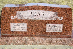
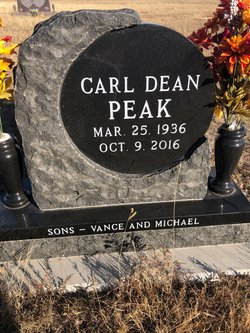
| Description | : | Son of Floyd Edward Peak and Vada Emaline Inman Peak Husband of Grace Lawson Peak buried Jan 18, 2010 Bruce Peak was born on January 18, 1916 on the Peak family farm south of Madrid Nebraska. He was the fourth of seven children born to Floyd and Vada Inman Peak. In 1924, the Peak family moved to a farm in the Blanche area southwest of Elsie. He attended school through the 8th grade at District #36. Bruce helped his father farm and he was married to Grace Lawson on February 6, 1935 at Grant. One son, Carl, and two daughters-Norma and Verna,... Read More |
frequently asked questions (FAQ):
-
Where is Bruce Carl Peak's memorial?
Bruce Carl Peak's memorial is located at: Oakwood Cemetery, Whitesboro, Grayson County, USA.
-
When did Bruce Carl Peak death?
Bruce Carl Peak death on 15 Jan 2010 in Grant, Perkins County, Nebraska, USA
-
Where are the coordinates of the Bruce Carl Peak's memorial?
Latitude: 33.6539001
Longitude: -96.9328003
Family Members:
Parent

Spouse

Siblings
Children
Flowers:


Nearby Cemetories:
1. Oakwood Cemetery
Whitesboro, Grayson County, USA
Coordinate: 33.6539001, -96.9328003
2. Diamond Cemetery
Grayson County, USA
Coordinate: 33.6570700, -96.9280240
3. Akers Cemetery
Callisburg, Cooke County, USA
Coordinate: 33.6800003, -96.9674988
4. Graines Cemetery
Callisburg, Cooke County, USA
Coordinate: 33.6914940, -96.9507446
5. Morris Cemetery
Cooke County, USA
Coordinate: 33.6147003, -96.9488983
6. Boston Farm Cemetery
Whitesboro, Grayson County, USA
Coordinate: 33.6952760, -96.9478720
7. Ben Dye Cemetery
Whitesboro, Grayson County, USA
Coordinate: 33.6053009, -96.9289017
8. Herod-Morris Cemetery
Cooke County, USA
Coordinate: 33.6067009, -96.9546967
9. Tuck Cemetery
Grayson County, USA
Coordinate: 33.6035995, -96.9049988
10. Brooks Family Cemetery
Whitesboro, Grayson County, USA
Coordinate: 33.6074700, -96.8939700
11. Brooks Cemetery
Grayson County, USA
Coordinate: 33.6072006, -96.8933029
12. Finally At Rest Cemetery
Whitesboro, Grayson County, USA
Coordinate: 33.6991789, -96.8876341
13. Eskew Cemetery
Grayson County, USA
Coordinate: 33.7139015, -96.9439011
14. Dixie Cemetery
Whitesboro, Grayson County, USA
Coordinate: 33.7107506, -96.9047318
15. Thompson Cemetery
Dixie, Grayson County, USA
Coordinate: 33.7147200, -96.9205930
16. Brothers Cemetery
Cooke County, USA
Coordinate: 33.6560840, -97.0086140
17. Welch Cemetery #1
Collinsville, Grayson County, USA
Coordinate: 33.5903015, -96.9141998
18. Nelson Grove Cemetery
Oak Ridge, Cooke County, USA
Coordinate: 33.6330986, -97.0093994
19. Sadler Cemetery
Sadler, Grayson County, USA
Coordinate: 33.6678009, -96.8482971
20. Macomb Cemetery
Whitesboro, Grayson County, USA
Coordinate: 33.5965996, -96.8560028
21. Callisburg Cemetery
Callisburg, Cooke County, USA
Coordinate: 33.7019005, -97.0218964
22. Union Hill Cemetery
Cooke County, USA
Coordinate: 33.6822014, -97.0342026
23. Collinsville Cemetery
Collinsville, Grayson County, USA
Coordinate: 33.5649986, -96.9100037
24. Liberty Hill Cemetery
Callisburg, Cooke County, USA
Coordinate: 33.7378006, -96.9772034