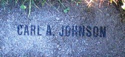
Carl Andrew Johnson
| Birth | : | 22 Mar 1868 |
| Death | : | 22 Sep 1925 |
| Burial | : | Richland Cemetery, Jefferson, Green County, USA |
| Coordinate | : | 42.5907300, -89.5826300 |
| Description | : | Washington Death Certificate Name: Carl A. Johnson Death Date: 22 Sep 1925 Death Place: Wenatchee, Chelan, Washington Gender: Male Age at Death: 57 years 6 months Estimated Birth Year: 1868 Marital Status: Married Spouse's Name: Alta Johnson Father's Name: Johnson Mother's Name: Olia Ranum Film Number: 2022252 Digital GS Number: 4220981 Image Number: 964 Volume/Page/Certificate Number: 2022252 |
frequently asked questions (FAQ):
-
Where is Carl Andrew Johnson's memorial?
Carl Andrew Johnson's memorial is located at: Richland Cemetery, Jefferson, Green County, USA.
-
When did Carl Andrew Johnson death?
Carl Andrew Johnson death on 22 Sep 1925 in
-
Where are the coordinates of the Carl Andrew Johnson's memorial?
Latitude: 42.5907300
Longitude: -89.5826300
Family Members:
Spouse
Children
Flowers:
Nearby Cemetories:
1. Richland Cemetery
Jefferson, Green County, USA
Coordinate: 42.5907300, -89.5826300
2. Calvary Cemetery
Monroe, Green County, USA
Coordinate: 42.5942001, -89.6232986
3. Greenwood Cemetery
Monroe, Green County, USA
Coordinate: 42.5922012, -89.6247025
4. Mount Vernon Cemetery
Juda, Green County, USA
Coordinate: 42.5955570, -89.5038150
5. Twin Grove Cemetery
Twin Grove, Green County, USA
Coordinate: 42.5352170, -89.5429260
6. Green County Farm Cemetery
Monroe, Green County, USA
Coordinate: 42.6243640, -89.6555190
7. Bethel Hawthorne Cemetery
Clarno, Green County, USA
Coordinate: 42.5718994, -89.6750031
8. Old Calvary Cemetery
Monroe, Green County, USA
Coordinate: 42.6021996, -89.6810989
9. East Clarno Cemetery
Clarno, Green County, USA
Coordinate: 42.5190500, -89.6208400
10. Dutch Hollow Cemetery
Sylvester, Green County, USA
Coordinate: 42.6730995, -89.5792007
11. Johnson Cemetery
Twin Grove, Green County, USA
Coordinate: 42.5031013, -89.5783005
12. West Clarno Pioneer Cemetery
Clarno, Green County, USA
Coordinate: 42.5190000, -89.6535400
13. Cold Springs Farm
Monroe, Green County, USA
Coordinate: 42.6758070, -89.6216400
14. Iliff Cemetery
Monroe, Green County, USA
Coordinate: 42.6397018, -89.6853027
15. Moores Cemetery
Juda, Green County, USA
Coordinate: 42.6288986, -89.4649963
16. Benkert Bushnell Cemetery
Stearns, Green County, USA
Coordinate: 42.6699982, -89.6611023
17. Basswood Cemetery
Oakley, Green County, USA
Coordinate: 42.5271988, -89.4785995
18. Oakley Union Cemetery
Oakley, Green County, USA
Coordinate: 42.5238790, -89.4783110
19. Figi Farm Cemetery
Clarno, Green County, USA
Coordinate: 42.5420900, -89.7056700
20. Bowen Family Homestead Cemetery
Clarno, Green County, USA
Coordinate: 42.5081600, -89.6713300
21. Old Pioneer Cemetery
Clarno, Green County, USA
Coordinate: 42.5267500, -89.7003400
22. Franklin Cemetery
Browntown, Green County, USA
Coordinate: 42.5875015, -89.7303009
23. Eldorado Cemetery
Orangeville, Stephenson County, USA
Coordinate: 42.4831009, -89.6136017
24. Truax Burial Grounds
Monticello, Green County, USA
Coordinate: 42.6976600, -89.5454700


