


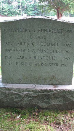
Carl Bertril Rundquist
| Birth | : | 24 Aug 1901 Sweden |
| Death | : | Jun 1982 New Hampshire, USA |
| Burial | : | Saint Patrick's Cemetery, Benton County, USA |
| Coordinate | : | 45.5827900, -94.0119700 |
| Description | : | Most records indicate that Carl was born on August 24, 1900 although the monument says 1901. The Social Security Death Index has him with the 1900 Date of Birth and Death as Jun 1982, last address in Goffstown, NH. Carl Bertril Rundquist became a citizen on April 7, 1941. |
frequently asked questions (FAQ):
-
Where is Carl Bertril Rundquist's memorial?
Carl Bertril Rundquist's memorial is located at: Saint Patrick's Cemetery, Benton County, USA.
-
When did Carl Bertril Rundquist death?
Carl Bertril Rundquist death on Jun 1982 in New Hampshire, USA
-
Where are the coordinates of the Carl Bertril Rundquist's memorial?
Latitude: 45.5827900
Longitude: -94.0119700
Family Members:
Parent

Siblings


Flowers:


Nearby Cemetories:
1. Saint Patrick's Cemetery
Benton County, USA
Coordinate: 45.5827900, -94.0119700
2. Saint Lawrence Cemetery
Duelm, Benton County, USA
Coordinate: 45.5738983, -93.9356003
3. United Church of Christ Cemetery
Sauk Rapids, Benton County, USA
Coordinate: 45.6325710, -94.0490520
4. Reformatory Cemetery
Haven Township, Sherburne County, USA
Coordinate: 45.5412030, -94.1127980
5. Saint Johns Lutheran Cemetery
Popple Creek, Benton County, USA
Coordinate: 45.6656800, -94.0235600
6. Popple Creek Pioneer Cemetery
Foley, Benton County, USA
Coordinate: 45.6763600, -94.0110700
7. Trinity Lutheran Cemetery
Sauk Rapids, Benton County, USA
Coordinate: 45.5867004, -94.1492004
8. Benton County Cemetery
Sauk Rapids, Benton County, USA
Coordinate: 45.5853004, -94.1500015
9. Hilltop Mausoleum
Sauk Rapids, Benton County, USA
Coordinate: 45.5863900, -94.1512400
10. Sacred Heart Cemetery
Sauk Rapids, Benton County, USA
Coordinate: 45.5872002, -94.1513977
11. Pioneer Cemetery
Sauk Rapids, Benton County, USA
Coordinate: 45.5846410, -94.1535190
12. Saint Clares Monastery Mausoleum
Sauk Rapids, Benton County, USA
Coordinate: 45.5878690, -94.1586060
13. Saint Francis River Cemetery
Duelm, Benton County, USA
Coordinate: 45.5671997, -93.8516998
14. Saint Pauls Lutheran Cemetery
Foley, Benton County, USA
Coordinate: 45.6670420, -93.8994690
15. Saint Johns Catholic Cemetery
Foley, Benton County, USA
Coordinate: 45.6666985, -93.8989029
16. Assumption Cemetery
Saint Cloud, Stearns County, USA
Coordinate: 45.5307999, -94.1650009
17. South Santiago Lutheran Cemetery
Clear Lake, Sherburne County, USA
Coordinate: 45.5088997, -93.8722000
18. Calvary Cemetery
Saint Cloud, Stearns County, USA
Coordinate: 45.5349998, -94.1757965
19. North Star Cemetery
Saint Cloud, Stearns County, USA
Coordinate: 45.5386009, -94.1802979
20. Church of the Annunciation Cemetery
Mayhew, Benton County, USA
Coordinate: 45.7012634, -94.1152344
21. Saint Mary Help of Christians Cemetery
Saint Augusta, Stearns County, USA
Coordinate: 45.4791985, -94.1492004
22. Clear Lake Cemetery
Clear Lake, Sherburne County, USA
Coordinate: 45.4424100, -93.9854900
23. Saint Marcus Cemetery
Clear Lake, Sherburne County, USA
Coordinate: 45.4407997, -94.0006027
24. Riverside Lutheran Cemetery
Ronneby, Benton County, USA
Coordinate: 45.6847000, -93.8685989