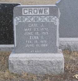
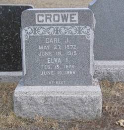
Carl John Crowe
| Birth | : | 27 May 1872 Parker, Linn County, Kansas, USA |
| Death | : | 19 Jun 1915 Great Falls, Cascade County, Montana, USA |
| Burial | : | Baptist Cemetery, Salem, Salem County, USA |
| Coordinate | : | 39.5621681, -75.4611053 |
| Plot | : | Old Highland |
| Description | : | The following provided by Find A Grave contributor "Cara": Great Falls Tribune (MT), 20 June 1915 C. J. Crowe Dead Carl J. Crowe, a rancher 43 years old, whose home was on the Greenfield bench, died last night at the Deaconess hospital. He is survived by his wife and three sons, Vernon, Lester and Clarence. The body was taken to the W. H. George company's chapel. Mr. Crowe formerly resided in Great Falls for a number of years and was engaged in the contracting business. |
frequently asked questions (FAQ):
-
Where is Carl John Crowe's memorial?
Carl John Crowe's memorial is located at: Baptist Cemetery, Salem, Salem County, USA.
-
When did Carl John Crowe death?
Carl John Crowe death on 19 Jun 1915 in Great Falls, Cascade County, Montana, USA
-
Where are the coordinates of the Carl John Crowe's memorial?
Latitude: 39.5621681
Longitude: -75.4611053
Family Members:
Parent
Spouse
Siblings
Children
Flowers:
Nearby Cemetories:
1. Baptist Cemetery
Salem, Salem County, USA
Coordinate: 39.5621681, -75.4611053
2. East View Cemetery
Salem, Salem County, USA
Coordinate: 39.5627480, -75.4561081
3. Mount Hope United Methodist Church Cemetery
Salem, Salem County, USA
Coordinate: 39.5660667, -75.4606781
4. Saint Mary's Roman Catholic Cemetery
Salem, Salem County, USA
Coordinate: 39.5637856, -75.4684753
5. Mount Pisgah AME Cemetery
Salem County, USA
Coordinate: 39.5549700, -75.4663900
6. First United Methodist Church Cemetery
Salem, Salem County, USA
Coordinate: 39.5695496, -75.4670868
7. Evergreen Cemetery
Salem, Salem County, USA
Coordinate: 39.5540000, -75.4652000
8. First Presbyterian Cemetery
Salem, Salem County, USA
Coordinate: 39.5736351, -75.4648819
9. Saint John's Episcopal Churchyard
Salem, Salem County, USA
Coordinate: 39.5744705, -75.4655151
10. Salem Friends Burial Ground
Salem, Salem County, USA
Coordinate: 39.5732307, -75.4705963
11. Mill Hollow Cemetery
Quinton, Salem County, USA
Coordinate: 39.5563120, -75.4305770
12. Alloway Creek Old Quaker Burial Ground
Lower Alloways Creek Township, Salem County, USA
Coordinate: 39.5202900, -75.4597000
13. Hancocks Bridge United Methodist Church Cemetery
Harmersville, Salem County, USA
Coordinate: 39.5023537, -75.4411850
14. Cedar Hill Friends Cemetery
Harmersville, Salem County, USA
Coordinate: 39.5014720, -75.4387800
15. Dunham Family Cemetery
Pennsville, Salem County, USA
Coordinate: 39.6138890, -75.5268330
16. Alloway Baptist Church Cemetery
Alloway, Salem County, USA
Coordinate: 39.5606308, -75.3655090
17. Battle of Quintons Bridge Graveyard
Quinton, Salem County, USA
Coordinate: 39.5130650, -75.3884040
18. Little Bethel A.M.E Church Cemetery
Marshalltown, Salem County, USA
Coordinate: 39.6381190, -75.4537830
19. Mount Zion AUMP Church Cemetery
Marshalltown, Salem County, USA
Coordinate: 39.6410060, -75.4554070
20. Alloway United Methodist Church Cemetery
Alloway, Salem County, USA
Coordinate: 39.5623207, -75.3586273
21. Berrys Chapel Cemetery
Quinton, Salem County, USA
Coordinate: 39.5137900, -75.3779510
22. Old Alloway Cemetery
Alloway, Salem County, USA
Coordinate: 39.5619545, -75.3549957
23. Lower Penns Neck Methodist Episcopal Cemetery
Pennsville, Salem County, USA
Coordinate: 39.6383120, -75.5164490
24. Finn's Point National Cemetery
Pennsville, Salem County, USA
Coordinate: 39.6110992, -75.5552979


