
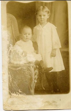

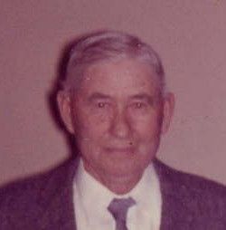
Carl Martin Majeski
| Birth | : | 10 Sep 1918 Flat Rock, Anderson County, South Carolina, USA |
| Death | : | 19 Dec 2006 Anderson, Anderson County, South Carolina, USA |
| Burial | : | Flat Rock Baptist Church Cemetery, Anderson, Anderson County, USA |
| Coordinate | : | 34.4271507, -82.6556931 |
| Description | : | He attended Flat Rock Presbyterian Church as long as he was able. In 1941, Mr. Majeski enlisted in the U.S. Air Force. He was stationed in Japan and Korea and Biloxi, MS. In 1948, he witnessed testing of the atomic bombs at Eniwetok Atoll in the Pacific. In Biloxi, he met Dora Torries Carmichael and they married in 1962. They lived in Anderson and in Elkins, West Virginia after he retired from the Air Force. After Dora's death in 1968, Carl moved back to Anderson to his parent's home on Elrod Road in the Flat Rock Community. He was preceded in... Read More |
frequently asked questions (FAQ):
-
Where is Carl Martin Majeski's memorial?
Carl Martin Majeski's memorial is located at: Flat Rock Baptist Church Cemetery, Anderson, Anderson County, USA.
-
When did Carl Martin Majeski death?
Carl Martin Majeski death on 19 Dec 2006 in Anderson, Anderson County, South Carolina, USA
-
Where are the coordinates of the Carl Martin Majeski's memorial?
Latitude: 34.4271507
Longitude: -82.6556931
Family Members:
Parent
Spouse
Siblings

Flowers:


Nearby Cemetories:
1. Flat Rock Baptist Church Cemetery
Anderson, Anderson County, USA
Coordinate: 34.4271507, -82.6556931
2. Mount Moriah Baptist Church Cemetery
Flat Rock, Anderson County, USA
Coordinate: 34.4331818, -82.6612930
3. South Lawn Memorial Gardens
Anderson, Anderson County, USA
Coordinate: 34.4184120, -82.6492300
4. Davenport Family Cemetery
Anderson, Anderson County, USA
Coordinate: 34.4422890, -82.6479530
5. Jefferson Chapel AME Church Cemetery
Anderson County, USA
Coordinate: 34.4356620, -82.6371100
6. Duncan Cemetery
Anderson County, USA
Coordinate: 34.4211300, -82.6162110
7. Middleton Road Baptist Church Cemetery
Anderson, Anderson County, USA
Coordinate: 34.4157250, -82.6176560
8. Dean Family Cemetery
Anderson County, USA
Coordinate: 34.4110100, -82.6935100
9. Norris Hill Presbyterian Church Cemetery
Anderson County, USA
Coordinate: 34.4577950, -82.6303180
10. Mount Hermon Baptist Church Cemetery
Anderson County, USA
Coordinate: 34.4438060, -82.6992420
11. Smith's Methodist Chapel Cemetery
Anderson, Anderson County, USA
Coordinate: 34.4071020, -82.6131590
12. Bethlehem United Methodist Church Cemetery
Anderson, Anderson County, USA
Coordinate: 34.4266060, -82.6003590
13. Mattison Family Cemetery
Anderson County, USA
Coordinate: 34.4214010, -82.5976770
14. Howard Family Cemetery
Starr, Anderson County, USA
Coordinate: 34.3758210, -82.6781300
15. Mountain Creek Baptist Church Cemetery
Anderson, Anderson County, USA
Coordinate: 34.4443510, -82.7190230
16. Old Mount Tabor Baptist Church Cemetery
Anderson, Anderson County, USA
Coordinate: 34.4826590, -82.6523020
17. Shekinah Glory New Testiment Church Cemetery
Starr, Anderson County, USA
Coordinate: 34.4423060, -82.7214950
18. Starr Baptist Church Cemetery
Starr, Anderson County, USA
Coordinate: 34.3768196, -82.6962128
19. New Silver Brook Cemetery
Anderson, Anderson County, USA
Coordinate: 34.4860992, -82.6331024
20. Shiloh Baptist Church Cemetery
Anderson, Anderson County, USA
Coordinate: 34.4018820, -82.5864280
21. Orr Mill Cemetery
Anderson, Anderson County, USA
Coordinate: 34.4906006, -82.6544037
22. McThursday Baptist Church Cemetery
Anderson County, USA
Coordinate: 34.4000015, -82.7268982
23. Westview Cemetery
Anderson, Anderson County, USA
Coordinate: 34.4921989, -82.6575012
24. Potters Field
Anderson, Anderson County, USA
Coordinate: 34.4908330, -82.6336110