
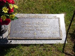
Carl S. Schell
| Birth | : | 12 Oct 1923 Pittsburg, Crawford County, Kansas, USA |
| Death | : | 8 Feb 1991 Joplin, Jasper County, Missouri, USA |
| Burial | : | Bridger Cemetery, Bridger, Carbon County, USA |
| Coordinate | : | 45.2825012, -108.9244003 |
| Plot | : | 7C-01 |
| Inscription | : | US Army Air Corps World War II |
| Description | : | OBITUARY: Carl S. Schell, 67, Joplin route 7, died at 12:25 p.m. Friday at his home after a long illness. Mr. Schell was born Oct. 12, 1923, at Pittsburg, Kan. He lived in Joplin before moving to Lowell, Ark. He returned to Joplin in 1976. He owned Carl Schell Trucking Co. in Joplin. He was a Methodist. He was a member of Joplin Elks Lodge No. 501, the Masonic Lodge of Washburn, the Joplin Scottish Rite and the Abou Ben Adhem Shrine of Springfield. He was an Army Air Corps veteran of World War II. Survivors include his wife; a... Read More |
frequently asked questions (FAQ):
-
Where is Carl S. Schell's memorial?
Carl S. Schell's memorial is located at: Bridger Cemetery, Bridger, Carbon County, USA.
-
When did Carl S. Schell death?
Carl S. Schell death on 8 Feb 1991 in Joplin, Jasper County, Missouri, USA
-
Where are the coordinates of the Carl S. Schell's memorial?
Latitude: 45.2825012
Longitude: -108.9244003
Family Members:
Parent
Spouse
Siblings
Children
Flowers:


Nearby Cemetories:
1. Bridger Cemetery
Bridger, Carbon County, USA
Coordinate: 45.2825012, -108.9244003
2. Mountain View Cemetery
Bridger, Carbon County, USA
Coordinate: 45.2588997, -108.8910980
3. Silver Tip Ranch Cemetery
Bridger, Carbon County, USA
Coordinate: 45.1889340, -108.9850340
4. Teeples Cemetery
Bridger, Carbon County, USA
Coordinate: 45.3248600, -108.7785880
5. Gebo Cemetery
Fromberg, Carbon County, USA
Coordinate: 45.4030000, -108.9242000
6. Beltz Cemetery
Carbon County, USA
Coordinate: 45.4049988, -109.0706024
7. Belfry Cemetery
Belfry, Carbon County, USA
Coordinate: 45.1200570, -109.0106020
8. Roberts Cemetery
Roberts, Carbon County, USA
Coordinate: 45.3605995, -109.1536026
9. Carbonado Cemetery
Joliet, Carbon County, USA
Coordinate: 45.4585991, -109.0139008
10. Clear Creek Cemetery
Roberts, Carbon County, USA
Coordinate: 45.2416992, -109.1931000
11. Bearcreek Cemetery
Bearcreek, Carbon County, USA
Coordinate: 45.1577797, -109.1380615
12. Joliet Cemetery
Joliet, Carbon County, USA
Coordinate: 45.4799995, -108.9985962
13. Bowler Cemetery
Bowler, Carbon County, USA
Coordinate: 45.1492004, -108.7018967
14. Rockvale Cemetery
Rockvale, Carbon County, USA
Coordinate: 45.4888770, -108.8626350
15. Red Lodge Cemetery
Red Lodge, Carbon County, USA
Coordinate: 45.1947200, -109.2605200
16. Sunrise Cemetery
Carbon County, USA
Coordinate: 45.3105450, -109.2888330
17. Chance Mountain View Cemetery
Chance, Carbon County, USA
Coordinate: 45.0447006, -109.0856018
18. John Henry Cemetery
Carbon County, USA
Coordinate: 45.2580986, -109.3031006
19. Tolman Cemetery
Carbon County, USA
Coordinate: 45.0611000, -109.1547012
20. Deuel Castange Cemetery
Red Lodge, Carbon County, USA
Coordinate: 45.3380000, -109.3104370
21. Big Day Cemetery
Pryor, Big Horn County, USA
Coordinate: 45.4169006, -108.5653000
22. Plenty Coups State Park Cemetery
Pryor, Big Horn County, USA
Coordinate: 45.4287870, -108.5491920
23. Sings Good-Stewart Family Cemetery
Pryor, Big Horn County, USA
Coordinate: 45.4076540, -108.5289690
24. Saint Olaf Cemetery
Luther, Carbon County, USA
Coordinate: 45.4064636, -109.3343735