
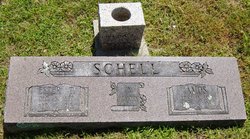
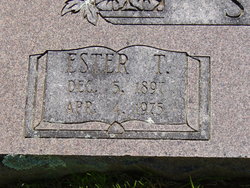
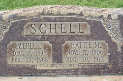
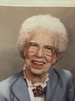
Ester Teresa Laughlin Schell
| Birth | : | 5 Dec 1897 |
| Death | : | 4 Apr 1975 |
| Burial | : | Saint Johns Catholic Cemetery, Independence, Buchanan County, USA |
| Coordinate | : | 42.4822006, -91.8957977 |
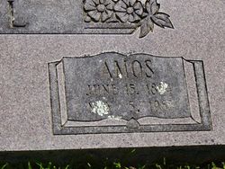
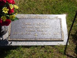
| Description | : | The Joplin Globe, Saturday, April 5, 1975 Mrs. Esther Schell WASHBURN, Mo. --- Mrs. Esther Teresa Schell, 77, Washburn route 1, died at 4:16 a.m. Friday at the Rogers Memorial Hospital, Rogers, Ark., where she had been a patient for one day. She was born December 5, 1897, in Stella, Mo., and was a member of the Methodist Church. On Feb. 2, 1917, she married Amos Schell, who died in 1965. Survivors include two sons, Carl Schell, Lowell, Ark., and Billy Schell, Washburn; a brother; six sisters; 10 grandchildren and nine great-grandchildren. Services will be at 2:00 p.m. Sunday at the Roller Methodist Church with... Read More |
frequently asked questions (FAQ):
-
Where is Ester Teresa Laughlin Schell's memorial?
Ester Teresa Laughlin Schell's memorial is located at: Saint Johns Catholic Cemetery, Independence, Buchanan County, USA.
-
When did Ester Teresa Laughlin Schell death?
Ester Teresa Laughlin Schell death on 4 Apr 1975 in
-
Where are the coordinates of the Ester Teresa Laughlin Schell's memorial?
Latitude: 42.4822006
Longitude: -91.8957977
Family Members:
Parent
Spouse
Siblings
Children
Flowers:


Nearby Cemetories:
1. Saint Johns Catholic Cemetery
Independence, Buchanan County, USA
Coordinate: 42.4822006, -91.8957977
2. Oakwood Cemetery
Independence, Buchanan County, USA
Coordinate: 42.4627991, -91.8927994
3. West Haven Cemetery
Independence, Buchanan County, USA
Coordinate: 42.4588678, -91.8986696
4. Buchanan County Poor Farm Cemetery
Independence, Buchanan County, USA
Coordinate: 42.4871560, -91.8647280
5. Mount Hope Cemetery
Independence, Buchanan County, USA
Coordinate: 42.4571991, -91.8914032
6. Buchanan County Home Cemetery
Independence, Buchanan County, USA
Coordinate: 42.4903050, -91.8596350
7. Wilson Cemetery
Independence, Buchanan County, USA
Coordinate: 42.4658012, -91.8516998
8. State Hospital Cemetery
Independence, Buchanan County, USA
Coordinate: 42.4455986, -91.9253006
9. Otterville Cemetery
Buchanan County, USA
Coordinate: 42.5158005, -91.9392014
10. Pine Creek Cemetery
Quasqueton, Buchanan County, USA
Coordinate: 42.4172400, -91.7867200
11. Littleton Cemetery
Littleton, Buchanan County, USA
Coordinate: 42.5338593, -92.0179520
12. Cedar Crest Cemetery
Jesup, Buchanan County, USA
Coordinate: 42.4782982, -92.0406036
13. Saint Athanasius Cemetery
Jesup, Buchanan County, USA
Coordinate: 42.4761009, -92.0421982
14. Rowley Cemetery
Rowley, Buchanan County, USA
Coordinate: 42.3716621, -91.8530655
15. Fairview Cemetery
Winthrop, Buchanan County, USA
Coordinate: 42.4692001, -91.7407990
16. Payne Cemetery
Winthrop, Buchanan County, USA
Coordinate: 42.5203018, -91.7453003
17. Saint Patricks Cemetery
Winthrop, Buchanan County, USA
Coordinate: 42.4653015, -91.7328033
18. Hickory Grove Cemetery
Quasqueton, Buchanan County, USA
Coordinate: 42.4207598, -91.7534684
19. Fontana Cemetery
Hazleton, Buchanan County, USA
Coordinate: 42.6046982, -91.9052963
20. Fremont Township Cemetery
Winthrop, Buchanan County, USA
Coordinate: 42.5046997, -91.7264023
21. Amish Cemetery
Buchanan County, USA
Coordinate: 42.5689011, -92.0224991
22. Quasqueton Cemetery
Quasqueton, Buchanan County, USA
Coordinate: 42.3994370, -91.7621231
23. Byron Township Cemetery
Buchanan County, USA
Coordinate: 42.5271988, -91.7275009
24. Saint Marys Cemetery
Hazleton, Buchanan County, USA
Coordinate: 42.6164017, -91.8983002