


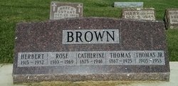
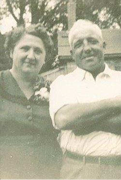
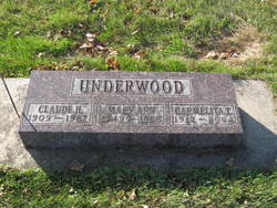
Carmelita Theresa Brown Underwood
| Birth | : | 15 Nov 1912 New Hampton, Chickasaw County, Iowa, USA |
| Death | : | 19 Mar 2004 New Hampton, Chickasaw County, Iowa, USA |
| Burial | : | Saint Marys Cemetery, New Hampton, Chickasaw County, USA |
| Coordinate | : | 43.0536003, -92.3217010 |
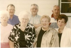
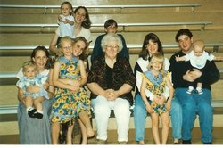
| Description | : | Carmelita Brown was born on November 15, 1912 near New Hampton, Chickasaw County, Iowa. Her parents were Thomas Brown and Catherine Lentz Brown, who resided near North Washington, Iowa. According to the Birth Record, Thomas was non-hispanic origin and 46 years of age at the time of Carmelita's birth. Catherine Lentz Brown was Carmelita Brown's mother. She is listed as non-hispanic and 37 years old in the Birth Record. Her occupation is listed as Farmer. "The Number Present at Birth to this Mother, including Present Birth" 12 "The number of Children to this Mother living" 5 Signed... Read More |
frequently asked questions (FAQ):
-
Where is Carmelita Theresa Brown Underwood's memorial?
Carmelita Theresa Brown Underwood's memorial is located at: Saint Marys Cemetery, New Hampton, Chickasaw County, USA.
-
When did Carmelita Theresa Brown Underwood death?
Carmelita Theresa Brown Underwood death on 19 Mar 2004 in New Hampton, Chickasaw County, Iowa, USA
-
Where are the coordinates of the Carmelita Theresa Brown Underwood's memorial?
Latitude: 43.0536003
Longitude: -92.3217010
Family Members:
Parent

Spouse
Siblings


Children
Flowers:


Nearby Cemetories:
1. Saint Marys Cemetery
New Hampton, Chickasaw County, USA
Coordinate: 43.0536003, -92.3217010
2. New Hampton Cemetery
New Hampton, Chickasaw County, USA
Coordinate: 43.0564003, -92.3210983
3. Children of Israel Cemetery
Chickasaw County, USA
Coordinate: 43.0583305, -92.3249969
4. Calvary Cemetery
New Hampton, Chickasaw County, USA
Coordinate: 43.0694000, -92.3097000
5. Chickasaw County Home Cemetery
Chickasaw County, USA
Coordinate: 43.0258086, -92.3179551
6. Eggleston Farm Cemetery
Chickasaw County, USA
Coordinate: 43.0916710, -92.3499985
7. Boyd Cemetery
Fredericksburg, Chickasaw County, USA
Coordinate: 43.0043983, -92.2285995
8. North East Iowa Garden of Memories
Chickasaw County, USA
Coordinate: 42.9724998, -92.2786026
9. Saint Marys Cemetery
North Washington, Chickasaw County, USA
Coordinate: 43.1128006, -92.4231033
10. Saint Boniface Cemetery
Ionia, Chickasaw County, USA
Coordinate: 43.0438995, -92.4550018
11. Jacksonville Cemetery
Chickasaw County, USA
Coordinate: 43.1122017, -92.2082977
12. Richland Township Cemetery
Chickasaw County, USA
Coordinate: 42.9589005, -92.3771973
13. Yankee Cemetery
Chickasaw County, USA
Coordinate: 43.1556015, -92.2378006
14. North Cemetery
Lawler, Chickasaw County, USA
Coordinate: 43.0835991, -92.1632996
15. Crane Creek Lutheran Cemetery
Jerico, Chickasaw County, USA
Coordinate: 43.1553001, -92.2341995
16. West Cemetery
Fredericksburg, Chickasaw County, USA
Coordinate: 42.9603004, -92.2136002
17. Rose Hill Cemetery
Fredericksburg, Chickasaw County, USA
Coordinate: 42.9743996, -92.1932983
18. Mount Carmel Cemetery
Lawler, Chickasaw County, USA
Coordinate: 43.0661011, -92.1511002
19. Mount Carroll Cemetery
Bassett, Chickasaw County, USA
Coordinate: 43.0602989, -92.4957962
20. Saint Johns German Lutheran Cemetery
Lawler, Chickasaw County, USA
Coordinate: 43.0637440, -92.1460500
21. Saint John Lutheran Cemetery
Dresden, Chickasaw County, USA
Coordinate: 42.9221992, -92.3082962
22. Sargeant Farm Cemetery
Chickasaw County, USA
Coordinate: 43.1777802, -92.2611084
23. Cedar View Cemetery
Chickasaw, Chickasaw County, USA
Coordinate: 43.0393982, -92.5064011
24. Jerico Lutheran Church Cemetery
Jerico, Chickasaw County, USA
Coordinate: 43.1850014, -92.2569427