
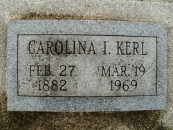
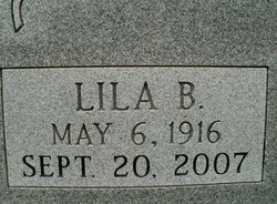
Caroline Isabella “Carrie” Reinhart Kerl
| Birth | : | 27 Feb 1882 Pawnee City, Pawnee County, Nebraska, USA |
| Death | : | 19 Mar 1969 Pawnee City, Pawnee County, Nebraska, USA |
| Burial | : | Elmwood Cemetery, Mexico, Audrain County, USA |
| Coordinate | : | 39.1685982, -91.9039001 |
| Plot | : | N-8-12-8 |
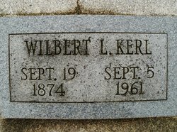
| Description | : | Married to Wilbert Luther Kerl on Oct. 27, 1909 in Pawnee City, NE. (Pawnee Library, book of obits in the Pawnee Republican.) |
frequently asked questions (FAQ):
-
Where is Caroline Isabella “Carrie” Reinhart Kerl's memorial?
Caroline Isabella “Carrie” Reinhart Kerl's memorial is located at: Elmwood Cemetery, Mexico, Audrain County, USA.
-
When did Caroline Isabella “Carrie” Reinhart Kerl death?
Caroline Isabella “Carrie” Reinhart Kerl death on 19 Mar 1969 in Pawnee City, Pawnee County, Nebraska, USA
-
Where are the coordinates of the Caroline Isabella “Carrie” Reinhart Kerl's memorial?
Latitude: 39.1685982
Longitude: -91.9039001
Family Members:
Spouse
Children
Flowers:


Nearby Cemetories:
1. Elmwood Cemetery
Mexico, Audrain County, USA
Coordinate: 39.1685982, -91.9039001
2. Saint Brendans Cemetery
Mexico, Audrain County, USA
Coordinate: 39.1727982, -91.9047012
3. Saint Matthew Columbarium
Mexico, Audrain County, USA
Coordinate: 39.1628400, -91.8906900
4. Saint Johns Lutheran Columbarium
Mexico, Audrain County, USA
Coordinate: 39.1800300, -91.8971600
5. Old Village Cemetery
Mexico, Audrain County, USA
Coordinate: 39.1757545, -91.8867722
6. First Presbyterian Columbarium
Mexico, Audrain County, USA
Coordinate: 39.1555900, -91.8880600
7. Jesse Cemetery
Mexico, Audrain County, USA
Coordinate: 39.1683900, -91.9384800
8. East Lawn Memorial Park
Mexico, Audrain County, USA
Coordinate: 39.1652985, -91.8482971
9. Trinity Cemetery
Audrain County, USA
Coordinate: 39.2392006, -91.9141998
10. Beaver Dam Cemetery
Audrain County, USA
Coordinate: 39.1004600, -91.9480300
11. Sunrise Christian Cemetery
Audrain County, USA
Coordinate: 39.2475320, -91.8926930
12. Lockridge Cemetery
Audrain County, USA
Coordinate: 39.1053009, -91.8403015
13. Willingham Cemetery #1
Mexico, Audrain County, USA
Coordinate: 39.2502100, -91.8405320
14. Bean Creek Cemetery
Audrain County, USA
Coordinate: 39.2505989, -91.8392029
15. Liberty Christian Church Cemetery
Skinner, Audrain County, USA
Coordinate: 39.2193400, -92.0098700
16. Willingham Cemetery #2
Mexico, Audrain County, USA
Coordinate: 39.2569560, -91.8453710
17. New Hope Christian Cemetery
Mexico, Audrain County, USA
Coordinate: 39.0801740, -91.8323560
18. Union Chapel Cemetery
Mexico, Audrain County, USA
Coordinate: 39.0806007, -91.8311005
19. Eubanks Cemetery
Audrain County, USA
Coordinate: 39.2588997, -91.8332977
20. Salt River Christian Church Cemetery
Mexico, Audrain County, USA
Coordinate: 39.1300200, -92.0340400
21. New Hope Cemetery
Mexico, Audrain County, USA
Coordinate: 39.1726420, -92.0498890
22. Littleby Methodist Episcopal Cemetery
Mexico, Audrain County, USA
Coordinate: 39.2223900, -91.7743200
23. Benton City Cemetery
Benton City, Audrain County, USA
Coordinate: 39.1326300, -91.7625500
24. Mount Zion Cemetery
Audrain County, USA
Coordinate: 39.2933006, -91.8933029