
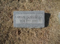
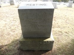
Caroline Ridgeway “Carrie” Iszard Brock
| Birth | : | 8 Jan 1874 Clayton, Gloucester County, New Jersey, USA |
| Death | : | 10 Nov 1930 Philadelphia, Philadelphia County, Pennsylvania, USA |
| Burial | : | Cedar Green Cemetery, Clayton, Gloucester County, USA |
| Coordinate | : | 39.6613998, -75.0852966 |
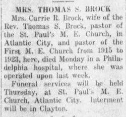
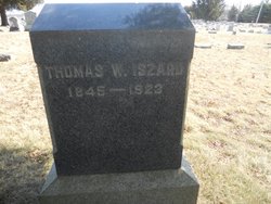
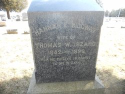
| Description | : | Survivors: Husband, Rev. Thomas S. Brock, pastor of St. Paul's M. E. Church, of Atlantic City. Died at Methodist Hospital. She was a member of the Iszard family and was born in Clayton. Parents: Thomas Whitney Iszard & Hannah E Ridgway |
frequently asked questions (FAQ):
-
Where is Caroline Ridgeway “Carrie” Iszard Brock's memorial?
Caroline Ridgeway “Carrie” Iszard Brock's memorial is located at: Cedar Green Cemetery, Clayton, Gloucester County, USA.
-
When did Caroline Ridgeway “Carrie” Iszard Brock death?
Caroline Ridgeway “Carrie” Iszard Brock death on 10 Nov 1930 in Philadelphia, Philadelphia County, Pennsylvania, USA
-
Where are the coordinates of the Caroline Ridgeway “Carrie” Iszard Brock's memorial?
Latitude: 39.6613998
Longitude: -75.0852966
Family Members:
Parent
Spouse
Siblings

Children
Flowers:


Nearby Cemetories:
1. Cedar Green Cemetery
Clayton, Gloucester County, USA
Coordinate: 39.6613998, -75.0852966
2. Land Of Canaan Cemetery
Glassboro, Gloucester County, USA
Coordinate: 39.6741982, -75.1085968
3. Gloucester County Veterans Memorial Cemetery
Williamstown, Gloucester County, USA
Coordinate: 39.6521279, -75.1163586
4. Downer United Methodist Church Cemetery
Williamstown, Gloucester County, USA
Coordinate: 39.6929700, -75.0523200
5. Aura Methodist Cemetery
Aura, Gloucester County, USA
Coordinate: 39.6725006, -75.1374969
6. Trinity Bible Cemetery
Glassboro, Gloucester County, USA
Coordinate: 39.7003610, -75.1133800
7. Saint Bridgets Cemetery
Glassboro, Gloucester County, USA
Coordinate: 39.7023300, -75.1159000
8. First United Methodist Church Cemetery
Glassboro, Gloucester County, USA
Coordinate: 39.7068900, -75.1081300
9. Franklinville African Methodist Episcopal Cemetery
Gloucester County, USA
Coordinate: 39.6138500, -75.0666600
10. Saint Thomas Episcopal Church Cemetery
Glassboro, Gloucester County, USA
Coordinate: 39.7079200, -75.1101500
11. Chickory Chapel Cemetery
Gloucester County, USA
Coordinate: 39.6244011, -75.1318970
12. Manahath Cemetery
Glassboro, Gloucester County, USA
Coordinate: 39.7154236, -75.1141129
13. Janvier Cemetery
Gloucester County, USA
Coordinate: 39.6194000, -75.0267029
14. Cross Keys Methodist Cemetery
Williamstown, Gloucester County, USA
Coordinate: 39.7124800, -75.0273100
15. Porchtown Zion Methodist Church Cemetery
Franklinville, Gloucester County, USA
Coordinate: 39.5895400, -75.0848000
16. Hardingville Cemetery
Hardingville, Gloucester County, USA
Coordinate: 39.6632100, -75.1790400
17. Williamstown Methodist Cemetery
Williamstown, Gloucester County, USA
Coordinate: 39.6838684, -74.9952698
18. Williamstown Old Methodist Cemetery
Williamstown, Gloucester County, USA
Coordinate: 39.6841812, -74.9935837
19. Williamstown Presbyterian Church Cemetery
Williamstown, Gloucester County, USA
Coordinate: 39.6821938, -74.9890823
20. Cost Family Cemetery
Pitman, Gloucester County, USA
Coordinate: 39.7307100, -75.1332310
21. Bunker Hill Presbyterian Church Cemetery
Gloucester County, USA
Coordinate: 39.7451600, -75.0849200
22. Friendship Methodist Cemetery
Monroeville, Salem County, USA
Coordinate: 39.6219101, -75.1827240
23. Plainville United Methodist Cemetery
Franklinville, Gloucester County, USA
Coordinate: 39.6034400, -75.0047800
24. Brotherhood Cemetery
Williamstown, Gloucester County, USA
Coordinate: 39.6863700, -74.9796200