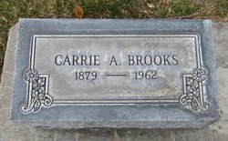
Carrie A. Dymond Brooks
| Birth | : | 5 Apr 1879 Bellwood, Butler County, Nebraska, USA |
| Death | : | Nov 1962 |
| Burial | : | Spring Creek Cemetery, Estill Springs, Franklin County, USA |
| Coordinate | : | 35.3060989, -86.1156006 |
| Plot | : | Lot-558-Section-A-Space-Alleyway |
| Description | : | Buried-Nov 21,1962 Lot-558 Section-A Space-Alleyway |
frequently asked questions (FAQ):
-
Where is Carrie A. Dymond Brooks's memorial?
Carrie A. Dymond Brooks's memorial is located at: Spring Creek Cemetery, Estill Springs, Franklin County, USA.
-
When did Carrie A. Dymond Brooks death?
Carrie A. Dymond Brooks death on Nov 1962 in
-
Where are the coordinates of the Carrie A. Dymond Brooks's memorial?
Latitude: 35.3060989
Longitude: -86.1156006
Family Members:
Flowers:
Nearby Cemetories:
1. Spring Creek Cemetery
Estill Springs, Franklin County, USA
Coordinate: 35.3060989, -86.1156006
2. Spring Creek Cemetery
Estill Springs, Franklin County, USA
Coordinate: 35.3185997, -86.1292038
3. Old Grays Mill Cemetery
Estill Springs, Franklin County, USA
Coordinate: 35.2872009, -86.1057968
4. Old Bethpage Cemetery
Estill Springs, Franklin County, USA
Coordinate: 35.2827988, -86.1132965
5. Bethpage Cemetery
Estill Springs, Franklin County, USA
Coordinate: 35.2775002, -86.1108017
6. Simpson Cemetery
Estill Springs, Franklin County, USA
Coordinate: 35.2821999, -86.1406021
7. Estill Springs Cemetery
Estill Springs, Franklin County, USA
Coordinate: 35.2764015, -86.1299973
8. Gossage Cemetery
Estill Springs, Franklin County, USA
Coordinate: 35.2742004, -86.1042023
9. Elder Cemetery
Franklin County, USA
Coordinate: 35.3088989, -86.0697021
10. Paynes Cemetery
Estill Springs, Franklin County, USA
Coordinate: 35.2778015, -86.0742035
11. Duncans Stagecoach Cemetery
Franklin County, USA
Coordinate: 35.2757988, -86.0730972
12. Mount Olivet Cemetery
Estill Springs, Franklin County, USA
Coordinate: 35.2797012, -86.1639023
13. Duncan Cemetery
Franklin County, USA
Coordinate: 35.2621994, -86.1393967
14. Corn Cemetery
Franklin County, USA
Coordinate: 35.2564011, -86.1074982
15. Elk River Primitive Baptist Church Cemetery
Capitol Hill, Franklin County, USA
Coordinate: 35.2928589, -86.0541508
16. Clemmons Cemetery
Franklin County, USA
Coordinate: 35.2566986, -86.1386032
17. Duncan Cemetery
Franklin County, USA
Coordinate: 35.2818985, -86.0563965
18. Fletcher Cemetery
Franklin County, USA
Coordinate: 35.2757988, -86.1727982
19. Hunt Cemetery
Estill Springs, Franklin County, USA
Coordinate: 35.2531013, -86.1616974
20. New Awalt Cemetery
Estill Springs, Franklin County, USA
Coordinate: 35.2694000, -86.1841700
21. Finney Cemetery
Franklin County, USA
Coordinate: 35.2703018, -86.0428009
22. Asia Cemetery
Estill Springs, Franklin County, USA
Coordinate: 35.2392006, -86.0864029
23. Featherston Cemetery
Franklin County, USA
Coordinate: 35.2766991, -86.0355988
24. Buckner Cemetery
Franklin County, USA
Coordinate: 35.2700005, -86.0397034


