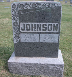
| Birth | : | 17 Apr 1823 Ostnor, Mora kommun, Dalarnas län, Sweden |
| Death | : | 1906 Dodge County, Nebraska, USA |
| Burial | : | Hillcrest Park Cemetery, Springfield, Hampden County, USA |
| Coordinate | : | 42.1274986, -72.4933014 |
| Description | : | Mini Biography By Harry H. Wagner Karin Carrie Frost was born on April 17, 1823 at Ostnar, Mora, Kopparberg, Sweden. She married Eric Johnson on February 14, 1856 at Gävle, Gävleborg, Sweden. She is the mother of Ephriam E. Johnson. The family emigrated from Sweden to Chicago about 1861. Her son, Ephriam came to Burt County, Nebraska about 1876 and to Dodge County about 1878. She and her son, Joe, came to Dodge County about 1878. According to the 1900 US Census she was then widowed and living with her son, Ephriam and his family in Logan... Read More |
frequently asked questions (FAQ):
-
Where is Carrie Karin Frost Johnson's memorial?
Carrie Karin Frost Johnson's memorial is located at: Hillcrest Park Cemetery, Springfield, Hampden County, USA.
-
When did Carrie Karin Frost Johnson death?
Carrie Karin Frost Johnson death on 1906 in Dodge County, Nebraska, USA
-
Where are the coordinates of the Carrie Karin Frost Johnson's memorial?
Latitude: 42.1274986
Longitude: -72.4933014
Family Members:
Spouse
Children
Flowers:
Nearby Cemetories:
1. Hillcrest Park Cemetery
Springfield, Hampden County, USA
Coordinate: 42.1274986, -72.4933014
2. Maplewood Cemetery
Springfield, Hampden County, USA
Coordinate: 42.1307983, -72.4957962
3. Gate of Heaven Cemetery
Springfield, Hampden County, USA
Coordinate: 42.1048370, -72.4778450
4. Saint Aloysius Cemetery
Springfield, Hampden County, USA
Coordinate: 42.1514015, -72.5139008
5. Kesser Israel Cemetery
Springfield, Hampden County, USA
Coordinate: 42.1145610, -72.5304670
6. Sinai Memorial Park
Springfield, Hampden County, USA
Coordinate: 42.1427994, -72.5291977
7. Sons of Israel Cemetery
Springfield, Hampden County, USA
Coordinate: 42.1143000, -72.5316000
8. City of Homes Cemetery
Springfield, Hampden County, USA
Coordinate: 42.1142980, -72.5316060
9. Saint Michael's Cemetery
Springfield, Hampden County, USA
Coordinate: 42.1240997, -72.5392914
10. Wachogue Cemetery
Springfield, Hampden County, USA
Coordinate: 42.0950860, -72.5109030
11. Polish National Cemetery
Springfield, Hampden County, USA
Coordinate: 42.1441870, -72.5417380
12. Bay Path Cemetery
Springfield, Hampden County, USA
Coordinate: 42.1231003, -72.5519028
13. Brookside Cemetery
East Longmeadow, Hampden County, USA
Coordinate: 42.0842819, -72.4809036
14. Adams Cemetery
Wilbraham, Hampden County, USA
Coordinate: 42.1082993, -72.4389038
15. Island Pond Cemetery
Ludlow, Hampden County, USA
Coordinate: 42.1749992, -72.4792023
16. Woodland Dell Cemetery
Wilbraham, Hampden County, USA
Coordinate: 42.1211014, -72.4263992
17. Oak Grove Cemetery
Springfield, Hampden County, USA
Coordinate: 42.1264000, -72.5625000
18. Saint Marks Memorial Garden
East Longmeadow, Hampden County, USA
Coordinate: 42.0725600, -72.5007430
19. Cherry Lane Cemetery
Springfield, Hampden County, USA
Coordinate: 42.0971985, -72.5689011
20. Green Lawn Cemetery
East Longmeadow, Hampden County, USA
Coordinate: 42.0645561, -72.5079727
21. Ludlow Center Cemetery
Ludlow, Hampden County, USA
Coordinate: 42.1893997, -72.4610977
22. Springfield Cemetery
Springfield, Hampden County, USA
Coordinate: 42.1015180, -72.5764990
23. Saint Benedict's Cemetery
Springfield, Hampden County, USA
Coordinate: 42.1194000, -72.5841980
24. Fuller Cemetery
Ludlow Center, Hampden County, USA
Coordinate: 42.1913350, -72.4602310


