
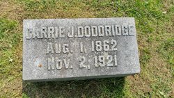
Carrie Robbins Doddridge
| Birth | : | 1 Aug 1862 USA |
| Death | : | 2 Nov 1921 Wayne County, Indiana, USA |
| Burial | : | Immanuel Lutheran Cemetery, Saint Ansgar, Mitchell County, USA |
| Coordinate | : | 43.3717003, -92.9257965 |
| Plot | : | 1-116-2 |
| Description | : | Info from Cemetery Records Married 24 December 1879 |
frequently asked questions (FAQ):
-
Where is Carrie Robbins Doddridge's memorial?
Carrie Robbins Doddridge's memorial is located at: Immanuel Lutheran Cemetery, Saint Ansgar, Mitchell County, USA.
-
When did Carrie Robbins Doddridge death?
Carrie Robbins Doddridge death on 2 Nov 1921 in Wayne County, Indiana, USA
-
Where are the coordinates of the Carrie Robbins Doddridge's memorial?
Latitude: 43.3717003
Longitude: -92.9257965
Family Members:
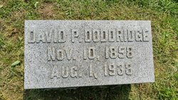
Spouse
Flowers:


Nearby Cemetories:
1. Immanuel Lutheran Cemetery
Saint Ansgar, Mitchell County, USA
Coordinate: 43.3717003, -92.9257965
2. Blakestad Cemetery
Saint Ansgar, Mitchell County, USA
Coordinate: 43.3711014, -92.9400024
3. First Lutheran Cemetery
Saint Ansgar, Mitchell County, USA
Coordinate: 43.3841705, -92.9194412
4. Saint Ansgar Cemetery
Saint Ansgar, Mitchell County, USA
Coordinate: 43.3777809, -92.9094391
5. McKinley Cemetery
Saint Ansgar, Mitchell County, USA
Coordinate: 43.3906400, -92.9368300
6. Riverview Cemetery
Saint Ansgar, Mitchell County, USA
Coordinate: 43.3430328, -92.9220200
7. Priem Cemetery
Carpenter, Mitchell County, USA
Coordinate: 43.3869019, -92.9747009
8. Saint Johns Lutheran Cemetery
Rock Creek, Mitchell County, USA
Coordinate: 43.3295560, -92.9849770
9. Saint Johns Lutheran Old Cemetery
Rock Creek, Mitchell County, USA
Coordinate: 43.3313904, -92.9897232
10. Oak Grove Cemetery
Mitchell, Mitchell County, USA
Coordinate: 43.3156013, -92.8707962
11. Newburg Cemetery
Carpenter, Mitchell County, USA
Coordinate: 43.4143982, -93.0049973
12. Ogden Cemetery
Otranto, Mitchell County, USA
Coordinate: 43.4366989, -92.9681015
13. Saint Peter Cemetery
Toeterville, Mitchell County, USA
Coordinate: 43.4402809, -92.8897171
14. Rustad Cemetery
Otranto, Mitchell County, USA
Coordinate: 43.4585991, -92.9400024
15. Deer Creek Lutheran Church Cemetery
Carpenter, Mitchell County, USA
Coordinate: 43.4297218, -93.0236130
16. Union Township Cemetery
Toeterville, Mitchell County, USA
Coordinate: 43.4578018, -92.8491974
17. Pleasant Hill Cemetery
Mona, Mitchell County, USA
Coordinate: 43.4768982, -92.9467010
18. Grafton Cemetery
Grafton, Worth County, USA
Coordinate: 43.3252983, -93.0631027
19. Osage Cemetery
Osage, Mitchell County, USA
Coordinate: 43.2916700, -92.8201700
20. Mona Cemetery
Mona, Mitchell County, USA
Coordinate: 43.4824982, -92.9402771
21. Emmanuel Lutheran Cemetery
Grafton, Worth County, USA
Coordinate: 43.3300018, -93.0691681
22. Stacyville Cemetery
Stacyville, Mitchell County, USA
Coordinate: 43.4294014, -92.7908020
23. Visitation Catholic Cemetery
Stacyville, Mitchell County, USA
Coordinate: 43.4430618, -92.7813873
24. Rock Creek Cemetery
Meroa, Mitchell County, USA
Coordinate: 43.2352791, -92.9225006