
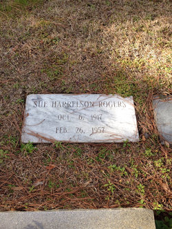
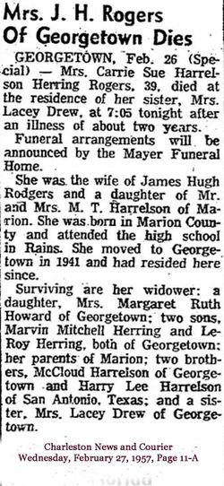
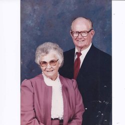
Carrie Sue Harrelson Rogers
| Birth | : | 6 Oct 1917 |
| Death | : | 26 Feb 1957 |
| Burial | : | Cracroft Cemetery, Ruapuna, Ashburton District, New Zealand |
| Coordinate | : | -43.9341900, 171.2989500 |
| Inscription | : | Sue Harrelson Rogers Oct 6 1917 Feb 26 1957 |
frequently asked questions (FAQ):
-
Where is Carrie Sue Harrelson Rogers's memorial?
Carrie Sue Harrelson Rogers's memorial is located at: Cracroft Cemetery, Ruapuna, Ashburton District, New Zealand.
-
When did Carrie Sue Harrelson Rogers death?
Carrie Sue Harrelson Rogers death on 26 Feb 1957 in
-
Where are the coordinates of the Carrie Sue Harrelson Rogers's memorial?
Latitude: -43.9341900
Longitude: 171.2989500
Family Members:
Parent
Spouse

Siblings
Children
Flowers:


Nearby Cemetories:
1. Cracroft Cemetery
Ruapuna, Ashburton District, New Zealand
Coordinate: -43.9341900, 171.2989500
2. Arundel Cemetery
Arundel, Timaru District, New Zealand
Coordinate: -43.9785690, 171.2838900
3. Church of the Holy Innocents Churchyard
Peel Forest, Timaru District, New Zealand
Coordinate: -43.8398520, 171.2471820
4. Ruapuna Cemetery
Ruapuna, Ashburton District, New Zealand
Coordinate: -43.8436110, 171.3680400
5. Woodbury Cemetery
Woodbury, Timaru District, New Zealand
Coordinate: -44.0360900, 171.2127000
6. St. Anne's Churchyard
Geraldine, Timaru District, New Zealand
Coordinate: -44.0836111, 171.1994444
7. Geraldine Cemetery
Geraldine, Timaru District, New Zealand
Coordinate: -44.0982600, 171.2407000
8. Hinds Cemetery
Hinds, Ashburton District, New Zealand
Coordinate: -44.0075580, 171.5735400
9. Westerfield Cemetery
Westerfield, Ashburton District, New Zealand
Coordinate: -43.8324380, 171.5806230
10. Upper Rangitata Cemetery
Rangitata, Timaru District, New Zealand
Coordinate: -43.7575112, 171.0907394
11. Mount Somers Cemetery
Mount Somers, Ashburton District, New Zealand
Coordinate: -43.7093900, 171.3962830
12. Windermere Cemetery
Windermere, Ashburton District, New Zealand
Coordinate: -43.9874945, 171.6232358
13. Mt Somers Old Cemetery
Mount Somers, Ashburton District, New Zealand
Coordinate: -43.7050700, 171.3969000
14. Winslow Cemetery
Winslow, Ashburton District, New Zealand
Coordinate: -43.9576290, 171.6522810
15. Saint Aidan's Churchyard
Geraldine, Timaru District, New Zealand
Coordinate: -44.1544420, 171.0980340
16. Temuka Cemetery
Temuka, Timaru District, New Zealand
Coordinate: -44.2499010, 171.3014390
17. Whareki Cemetery
Temuka, Timaru District, New Zealand
Coordinate: -44.2558600, 171.2734500
18. Longbeach Estate Chapel
Longbeach, Ashburton District, New Zealand
Coordinate: -44.0941090, 171.6884504
19. Alford Forest Cemetery
Alford Forest, Ashburton District, New Zealand
Coordinate: -43.6428200, 171.4933300
20. Pioneer Park Memorial
Ashburton, Ashburton District, New Zealand
Coordinate: -43.9106400, 171.7485300
21. St David’s Anglican Churchyard
Mackenzie District, New Zealand
Coordinate: -44.1706380, 170.9887810
22. Waterton Cemetery
Eiffelton, Ashburton District, New Zealand
Coordinate: -44.0640000, 171.7260000
23. Ashburton Public Cemetery
Ashburton, Ashburton District, New Zealand
Coordinate: -43.8903240, 171.7702810
24. Pleasant Point Cemetery
Pleasant Point, Timaru District, New Zealand
Coordinate: -44.2615490, 171.1237320