

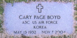
Cary Page Boyd
| Birth | : | 13 May 1932 Henderson, Vance County, North Carolina, USA |
| Death | : | 7 Nov 2004 Henderson, Vance County, North Carolina, USA |
| Burial | : | Mount Hope Cemetery, Independence, Montgomery County, USA |
| Coordinate | : | 37.2413300, -95.7060050 |
| Description | : | Cary Page Boyd (May 13, 1932 – Nov. 7, 2004) Age 72 of Henderson, passed away at his home on Oxford Road to be with the Lord Sunday November 7, 2004. Born at Maria Parham Hospital, Henderson NC on May 13, 1932, Cary attended Henderson High School. At age 18 he enlisted to serve his country in the U.S. Air Force, completed basic training in 1950 at Lackland AFB, San Antonio TX, then was stationed at Keesler AFB, Biloxi MS for radar operator training, and on to Norton AFB, San Bernadino CA and Edwards AFB, Mojave Desert... Read More |
frequently asked questions (FAQ):
-
Where is Cary Page Boyd's memorial?
Cary Page Boyd's memorial is located at: Mount Hope Cemetery, Independence, Montgomery County, USA.
-
When did Cary Page Boyd death?
Cary Page Boyd death on 7 Nov 2004 in Henderson, Vance County, North Carolina, USA
-
Where are the coordinates of the Cary Page Boyd's memorial?
Latitude: 37.2413300
Longitude: -95.7060050
Family Members:
Parent
Flowers:


Nearby Cemetories:
1. Mount Hope Cemetery
Independence, Montgomery County, USA
Coordinate: 37.2413300, -95.7060050
2. Calvary Cemetery
Independence, Montgomery County, USA
Coordinate: 37.2486000, -95.7043991
3. Saint Andrews Cemetery
Independence, Montgomery County, USA
Coordinate: 37.2566986, -95.6658020
4. Pratt Cemetery
Montgomery County, USA
Coordinate: 37.2324982, -95.6557999
5. Le Hunt Cemetery
Montgomery County, USA
Coordinate: 37.2744300, -95.7586200
6. Radical Cemetery
Montgomery County, USA
Coordinate: 37.2882996, -95.7416992
7. Bethel Cemetery
Independence, Montgomery County, USA
Coordinate: 37.2761002, -95.6457977
8. Montgomery County Poor Farm Cemetery
Liberty, Montgomery County, USA
Coordinate: 37.1888590, -95.6493690
9. Choteau Cemetery
Independence, Montgomery County, USA
Coordinate: 37.3194700, -95.6746700
10. Harmony Cemetery
Cherryvale, Montgomery County, USA
Coordinate: 37.2324982, -95.5950012
11. Quaker Cemetery
Elk City, Montgomery County, USA
Coordinate: 37.2395900, -95.8243400
12. Thompson Homestead Cemetery
Liberty, Montgomery County, USA
Coordinate: 37.1767000, -95.6183100
13. Krone Cemetery
Montgomery County, USA
Coordinate: 37.3302400, -95.7494600
14. Highland Cemetery
Montgomery County, USA
Coordinate: 37.2092018, -95.8283005
15. Saint Francis Xavier Cemetery
Cherryvale, Montgomery County, USA
Coordinate: 37.2633018, -95.5753021
16. Liberty Cemetery
Liberty, Montgomery County, USA
Coordinate: 37.1581890, -95.6001580
17. Pleasant Dale Cemetery
Cherryvale, Montgomery County, USA
Coordinate: 37.3139700, -95.5860700
18. Parker Cemetery
Montgomery County, USA
Coordinate: 37.2630997, -95.8572006
19. Spring Hill Cemetery
Montgomery County, USA
Coordinate: 37.1235600, -95.6595500
20. Simpson Cemetery
Elk City, Montgomery County, USA
Coordinate: 37.3269005, -95.8186035
21. Centennial Cemetery
Cherryvale, Montgomery County, USA
Coordinate: 37.2296982, -95.5466995
22. Hinton Cemetery
Liberty, Montgomery County, USA
Coordinate: 37.1384900, -95.6101000
23. Spindletop Cemetery
Cherryvale, Montgomery County, USA
Coordinate: 37.2958400, -95.5570700
24. All Saints Cemetery
Liberty, Montgomery County, USA
Coordinate: 37.1542015, -95.5757980