
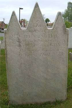
Catharine Tingley Hall
| Birth | : | 1758 |
| Death | : | 10 Nov 1810 |
| Burial | : | Calvary Cemetery, Omaha, Douglas County, USA |
| Coordinate | : | 41.2364006, -96.0294037 |
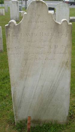
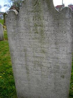
| Description | : | Wife of Col. David Hall died aged 32 years. She was married by her brother, The Rev. Samuel Tingley, the Rector of St. Peters Episcopal Church in Lewes, Delaware to David Hall the son of David Hall and Mary Magdalene Kollock. Catharine's parents were Samuel Tingley and Agnus Blanck. Agnus was the daughter of Casparas and Agnietje Blanck. Her parents names were Dutch for Casper and Agnes Blank. |
frequently asked questions (FAQ):
-
Where is Catharine Tingley Hall's memorial?
Catharine Tingley Hall's memorial is located at: Calvary Cemetery, Omaha, Douglas County, USA.
-
When did Catharine Tingley Hall death?
Catharine Tingley Hall death on 10 Nov 1810 in
-
Where are the coordinates of the Catharine Tingley Hall's memorial?
Latitude: 41.2364006
Longitude: -96.0294037
Family Members:
Spouse
Children
Flowers:


Nearby Cemetories:
1. Calvary Cemetery
Omaha, Douglas County, USA
Coordinate: 41.2364006, -96.0294037
2. Evergreen Memorial Park Cemetery
Omaha, Douglas County, USA
Coordinate: 41.2393990, -96.0355988
3. Resurrection Cemetery
Omaha, Douglas County, USA
Coordinate: 41.2344208, -96.0365448
4. Ak-Sar-Ben Racetrack Grounds
Omaha, Douglas County, USA
Coordinate: 41.2414703, -96.0159607
5. Saint Andrews Episcopal Church Columbarium
Omaha, Douglas County, USA
Coordinate: 41.2492500, -96.0427500
6. Countryside Community Church Columbarium
Omaha, Douglas County, USA
Coordinate: 41.2483660, -96.0500270
7. Westlawn-Hillcrest Memorial Park
Omaha, Douglas County, USA
Coordinate: 41.2346992, -95.9966965
8. Bohemian Cemetery
Omaha, Douglas County, USA
Coordinate: 41.2388992, -95.9955978
9. Beth El Cemetery
Ralston, Douglas County, USA
Coordinate: 41.2117004, -96.0428009
10. Holy Sepulchre Cemetery
Omaha, Douglas County, USA
Coordinate: 41.2543983, -95.9875031
11. Douglas County Poor Farm Cemetery
Omaha, Douglas County, USA
Coordinate: 41.2437240, -95.9723480
12. Graceland Park Cemetery
Omaha, Douglas County, USA
Coordinate: 41.2113991, -95.9785995
13. Saint Mary Magdalene Cemetery
Omaha, Douglas County, USA
Coordinate: 41.2039420, -95.9850610
14. All Saints Episcopal Church Columbarium
Omaha, Douglas County, USA
Coordinate: 41.2785000, -96.0579000
15. First Central Congregational Columbarium
Omaha, Douglas County, USA
Coordinate: 41.2563456, -95.9658365
16. Nash Chapel Crypt
Omaha, Douglas County, USA
Coordinate: 41.2665090, -95.9721790
17. Saint Mary's Cemetery
Omaha, Douglas County, USA
Coordinate: 41.2042007, -95.9646988
18. Papillion Cemetery
Papillion, Sarpy County, USA
Coordinate: 41.1758003, -96.0410995
19. Portal Cemetery
Sarpy County, USA
Coordinate: 41.1838989, -96.0802994
20. Servants of Mary Cemetery
Omaha, Douglas County, USA
Coordinate: 41.3017170, -96.0258260
21. Prospect Hill Cemetery
Omaha, Douglas County, USA
Coordinate: 41.2780991, -95.9593964
22. Mount Hope Cemetery
Omaha, Douglas County, USA
Coordinate: 41.3041992, -96.0310974
23. Saint Johns Cemetery
Bellevue, Sarpy County, USA
Coordinate: 41.1864014, -95.9682999
24. Pleasant Hill Cemetery
Omaha, Douglas County, USA
Coordinate: 41.2558975, -96.1194687