
| Birth | : | 1927 South Dakota, USA |
| Death | : | 1927 South Dakota, USA |
| Burial | : | Rose Hill Cemetery, McCook County, USA |
| Coordinate | : | 43.5119019, -97.3478012 |
| Plot | : | Lot 2, Site 5 |
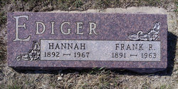
| Description | : | Catherin was the infant daughter of Frank and Hannah Wibben Ediger, and the granddaughter of Henry Ediger and Maria Tiahrt Ediger. Information was prepared by Ken Tiahrt with the generous assistance of the cemetery sexton. Rose Hill Cemetery was a formal part of the Bethel Mennonite Church, which was relocated to the Historical Museum at Freeman College in Freeman, South Dakota. The Tiahrts were originally from Trzpiola, near Wola Wodzynska, Poland (formerly Prussia). http://www.rootsweb.ancestry.com/~sdmccook/rosehillcemetery.html This Rose Hill Cemetery is located in rural McCook County. Section 32 - Grant Township - McCook County - SD |
frequently asked questions (FAQ):
-
Where is Catherin D. Ediger's memorial?
Catherin D. Ediger's memorial is located at: Rose Hill Cemetery, McCook County, USA.
-
When did Catherin D. Ediger death?
Catherin D. Ediger death on 1927 in South Dakota, USA
-
Where are the coordinates of the Catherin D. Ediger's memorial?
Latitude: 43.5119019
Longitude: -97.3478012
Family Members:
Parent
Siblings

Flowers:


Nearby Cemetories:
1. Rose Hill Cemetery
McCook County, USA
Coordinate: 43.5119019, -97.3478012
2. Riverside Cemetery
Canistota, McCook County, USA
Coordinate: 43.5360985, -97.3283005
3. Our Lady of Lourdes Catholic Cemetery
Dolton, Turner County, USA
Coordinate: 43.4871320, -97.3732960
4. West Vermillion Cemetery
Marion, Turner County, USA
Coordinate: 43.4706001, -97.3189011
5. Dick Cemetery
Turner County, USA
Coordinate: 43.4528008, -97.3319016
6. Adrian Cemetery
Freeman, Hutchinson County, USA
Coordinate: 43.4730320, -97.4196550
7. Mennonite Cemetery
Dolton, Turner County, USA
Coordinate: 43.4472008, -97.3788986
8. Pleasant Prairie Cemetery
Bridgewater, McCook County, USA
Coordinate: 43.5430984, -97.4496994
9. Monroe Reformed Church Cemetery
McCook County, USA
Coordinate: 43.5004100, -97.2358170
10. First Church of God Cemetery
Marion, Turner County, USA
Coordinate: 43.4447000, -97.2727000
11. Spring Valley Baptist Cemetery
Spring Valley Township, McCook County, USA
Coordinate: 43.5325920, -97.2290730
12. Tieszen Cemetery
Marion, Turner County, USA
Coordinate: 43.4219017, -97.3388977
13. Anna Koerner Burial Site
Hutchinson County, USA
Coordinate: 43.4290258, -97.4196065
14. Saint Marys Catholic Cemetery
Marion, Turner County, USA
Coordinate: 43.4371986, -97.2596970
15. Saint Stephens Cemetery
Bridgewater, McCook County, USA
Coordinate: 43.5574989, -97.4766998
16. Buller-Ensz Cemetery
Turner County, USA
Coordinate: 43.4186000, -97.2828500
17. Canistota Cemetery
Canistota, McCook County, USA
Coordinate: 43.6035995, -97.2671967
18. Greenwood Cemetery
Marion, Turner County, USA
Coordinate: 43.4150009, -97.2493973
19. Bridgewater Cemetery
Bridgewater, McCook County, USA
Coordinate: 43.5541600, -97.5059400
20. Kleinkassel Cemetery
Hutchinson County, USA
Coordinate: 43.4369011, -97.4997025
21. Hutterthal Mennonite Church Cemetery
Freeman, Hutchinson County, USA
Coordinate: 43.4041400, -97.4605000
22. Tschetter Cemetery
Freeman, Hutchinson County, USA
Coordinate: 43.3866997, -97.4197006
23. Hofer Cemetery
Freeman, Hutchinson County, USA
Coordinate: 43.4726830, -97.5299150
24. Rasmussen Cemetery
Bridgewater, McCook County, USA
Coordinate: 43.5283012, -97.5567017