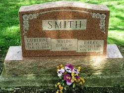
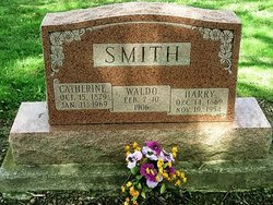
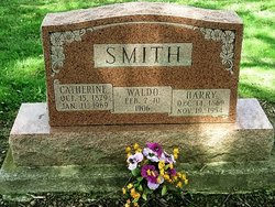
Catherine Daily Smith
| Birth | : | 15 Oct 1879 Huntington County, Indiana, USA |
| Death | : | 11 Jan 1969 Allen County, Indiana, USA |
| Burial | : | Laurelwood Cemetery, Stroudsburg, Monroe County, USA |
| Coordinate | : | 40.9757996, -75.1992035 |
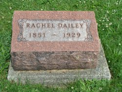
| Description | : | Daughter of Samuel Dailey and Rachel Jones (d/c shows Rachel Brister?) Wife of Harry. Catherine lived to be 89 years of age. |
frequently asked questions (FAQ):
-
Where is Catherine Daily Smith's memorial?
Catherine Daily Smith's memorial is located at: Laurelwood Cemetery, Stroudsburg, Monroe County, USA.
-
When did Catherine Daily Smith death?
Catherine Daily Smith death on 11 Jan 1969 in Allen County, Indiana, USA
-
Where are the coordinates of the Catherine Daily Smith's memorial?
Latitude: 40.9757996
Longitude: -75.1992035
Family Members:
Parent
Spouse
Siblings
Children
Flowers:
Nearby Cemetories:
1. Laurelwood Cemetery
Stroudsburg, Monroe County, USA
Coordinate: 40.9757996, -75.1992035
2. Stroudsburg Cemetery
Stroudsburg, Monroe County, USA
Coordinate: 40.9817000, -75.2030000
3. Hollinshead Cemetery
Stroudsburg, Monroe County, USA
Coordinate: 40.9799054, -75.2077550
4. Burial Ground of Friends
Stroudsburg, Monroe County, USA
Coordinate: 40.9835108, -75.1956191
5. Friends Burial Ground
Stroudsburg, Monroe County, USA
Coordinate: 40.9835892, -75.1956482
6. Christ Episcopal Church Columbarium
Stroudsburg, Monroe County, USA
Coordinate: 40.9876010, -75.1955630
7. Dansbury Cemetery
Stroudsburg, Monroe County, USA
Coordinate: 40.9896000, -75.1876000
8. Kellers Cherry Valley Cemetery
Monroe County, USA
Coordinate: 40.9601000, -75.2104000
9. Saint Matthews Catholic Church Cemetery
East Stroudsburg, Monroe County, USA
Coordinate: 40.9872040, -75.1768990
10. Prospect Cemetery
East Stroudsburg, Monroe County, USA
Coordinate: 40.9892280, -75.1752110
11. Saint Matthew's Cemetery #1
East Stroudsburg, Monroe County, USA
Coordinate: 40.9946990, -75.1825850
12. Poplar Valley United Methodist Church Cemetery
Stroudsburg, Monroe County, USA
Coordinate: 40.9500000, -75.1954000
13. Shafer Schoolhouse Cemetery
Monroe County, USA
Coordinate: 40.9751000, -75.2451000
14. Delaware Water Gap Cemetery
Delaware Water Gap, Monroe County, USA
Coordinate: 40.9882000, -75.1488000
15. Beakleyville Baptist Church Cemetery
Monroe County, USA
Coordinate: 41.0207000, -75.1850000
16. Saint Marks Church Cemetery
Delaware Water Gap, Monroe County, USA
Coordinate: 40.9979000, -75.1371000
17. Storm Family Burial Ground
Snydersville, Monroe County, USA
Coordinate: 40.9665985, -75.2689209
18. Cherry Valley United Methodist Church Cemetery
Monroe County, USA
Coordinate: 40.9375000, -75.2543000
19. Franklin Hill Cemetery
Monroe County, USA
Coordinate: 41.0194016, -75.1433029
20. Miller Family Burial Ground
Stroudsburg, Monroe County, USA
Coordinate: 40.9499891, -75.2797181
21. Saint Johns Cemetery
Bartonsville, Monroe County, USA
Coordinate: 40.9924190, -75.2848860
22. Custards Cemetery
Bartonsville, Monroe County, USA
Coordinate: 40.9925480, -75.2854500
23. North Bangor Cemetery
Upper Mount Bethel Township, Northampton County, USA
Coordinate: 40.9011000, -75.2121000
24. Saint Pauls Lutheran Cemetery
Marshalls Creek, Monroe County, USA
Coordinate: 41.0382000, -75.1405000

