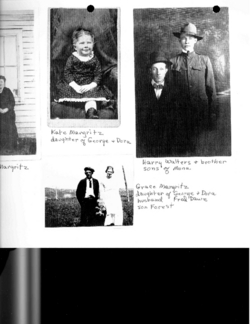
| Birth | : | 29 Nov 1875 Freeport, Stephenson County, Illinois, USA |
| Death | : | 27 Mar 1953 USA |
| Burial | : | El Camino Memorial Park, San Diego, San Diego County, USA |
| Coordinate | : | 32.8955994, -117.1793976 |
| Description | : | Maiden name Catherine V. Margritz "Kate", she was the wife of Rupert S. Honey. Kate was one of eight children of George Oliver Margritz & Dorothy Elizabeth (dahl) Margritz. Catherine and Rupert had two kids: Hazel Rupert Honey, who married Axel Sorenson and Roy Rupert Honey, who married Hazel Cantlin. |
frequently asked questions (FAQ):
-
Where is Catherine V. Margritz Honey's memorial?
Catherine V. Margritz Honey's memorial is located at: El Camino Memorial Park, San Diego, San Diego County, USA.
-
When did Catherine V. Margritz Honey death?
Catherine V. Margritz Honey death on 27 Mar 1953 in USA
-
Where are the coordinates of the Catherine V. Margritz Honey's memorial?
Latitude: 32.8955994
Longitude: -117.1793976
Family Members:
Parent
Spouse
Siblings
Flowers:
Nearby Cemetories:
1. El Camino Memorial Park
San Diego, San Diego County, USA
Coordinate: 32.8955994, -117.1793976
2. San Diego Pet Memorial Park
Miramar, San Diego County, USA
Coordinate: 32.8905940, -117.1698280
3. Miramar National Cemetery
San Diego, San Diego County, USA
Coordinate: 32.8715740, -117.1920030
4. Good Samaritan Episcopal Church Memorial Garden
San Diego, San Diego County, USA
Coordinate: 32.8771300, -117.2133400
5. Sorrento Valley Pet Cemetery
Sorrento Mesa, San Diego County, USA
Coordinate: 32.9002230, -117.2210230
6. Anton Knechtel Gravesite
San Diego, San Diego County, USA
Coordinate: 32.9371300, -117.2144300
7. Carmel Valley Cemetery
San Diego, San Diego County, USA
Coordinate: 32.9412003, -117.2191010
8. John Joseph Eichar Burial Site
San Diego County, USA
Coordinate: 32.9394820, -117.1293430
9. Linda Vista Cemetery
Miramar, San Diego County, USA
Coordinate: 32.8800670, -117.0918130
10. Mount Soledad National Veterans Memorial
La Jolla, San Diego County, USA
Coordinate: 32.8398800, -117.2446900
11. Saint James By-The-Sea Episcopal Church Cemetery
La Jolla, San Diego County, USA
Coordinate: 32.8448240, -117.2767710
12. Tierrasanta Lutheran Church Memorial Garden
San Diego, San Diego County, USA
Coordinate: 32.8303840, -117.0866840
13. Church of The Nativity Columbarium
Rancho Santa Fe, San Diego County, USA
Coordinate: 32.9971120, -117.1978040
14. Saint Andrews by the Sea Church Columbarium
Pacific Beach, San Diego County, USA
Coordinate: 32.7950430, -117.2496340
15. Mission San Diego de Alcala Cemetery
San Diego, San Diego County, USA
Coordinate: 32.7858009, -117.1103973
16. First United Methodist Church Memorial Garden
San Diego, San Diego County, USA
Coordinate: 32.7674040, -117.1425440
17. Presidio Hill Cemetery
Old Town San Diego, San Diego County, USA
Coordinate: 32.7592960, -117.1949920
18. Beth Sarim House
San Diego, San Diego County, USA
Coordinate: 32.7712330, -117.0992590
19. First Unitarian Universalist Church of San Diego
San Diego, San Diego County, USA
Coordinate: 32.7535730, -117.1664870
20. Normal Heights United Methodist Church Columbarium
San Diego, San Diego County, USA
Coordinate: 32.7625900, -117.1186200
21. El Campo Santo Cemetery
San Diego, San Diego County, USA
Coordinate: 32.7514000, -117.1922989
22. Olivenhain Cemetery
Encinitas, San Diego County, USA
Coordinate: 33.0325510, -117.2420400
23. Calvary Cemetery
San Diego, San Diego County, USA
Coordinate: 32.7489014, -117.1766968
24. Saint Dunstans Episcopal Church Columbarium
San Diego, San Diego County, USA
Coordinate: 32.7963070, -117.0498750


