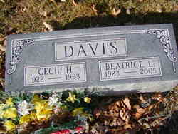
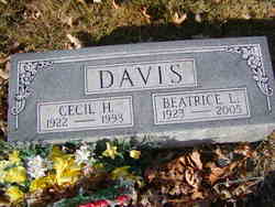
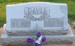
Cecil Hammett Davis
| Birth | : | 21 Jan 1922 Moberly, Randolph County, Missouri, USA |
| Death | : | 8 Jun 1993 Saint Charles, St. Charles County, Missouri, USA |
| Burial | : | Chalmers Cemetery, Chalmers, White County, USA |
| Coordinate | : | 40.6481018, -86.8683014 |
| Plot | : | Block 11, Lot 40, Grave 1NW |
| Description | : | Age 71. Survived by a son, Ronald C. Davis. |
frequently asked questions (FAQ):
-
Where is Cecil Hammett Davis's memorial?
Cecil Hammett Davis's memorial is located at: Chalmers Cemetery, Chalmers, White County, USA.
-
When did Cecil Hammett Davis death?
Cecil Hammett Davis death on 8 Jun 1993 in Saint Charles, St. Charles County, Missouri, USA
-
Where are the coordinates of the Cecil Hammett Davis's memorial?
Latitude: 40.6481018
Longitude: -86.8683014
Family Members:
Parent
Spouse
Siblings
Flowers:
Nearby Cemetories:
1. Chalmers Cemetery
Chalmers, White County, USA
Coordinate: 40.6481018, -86.8683014
2. Carr Cemetery
Chalmers, White County, USA
Coordinate: 40.6418991, -86.8649979
3. High Cemetery
Chalmers, White County, USA
Coordinate: 40.6851350, -86.8636210
4. IOOF Brookston Cemetery
Brookston, White County, USA
Coordinate: 40.6046982, -86.8741989
5. Alkire Cemetery
Brookston, White County, USA
Coordinate: 40.6191940, -86.8220139
6. Spring Creek Cemetery
Brookston, White County, USA
Coordinate: 40.6208000, -86.8022003
7. Smelcer Cemetery
Brookston, White County, USA
Coordinate: 40.5908012, -86.8414001
8. Harvey and Phebus Cemetery
White County, USA
Coordinate: 40.6474991, -86.7853012
9. Wolverton Cemetery
Monticello, White County, USA
Coordinate: 40.6742930, -86.7846320
10. Blizzard Cemetery
Pittsburg, Carroll County, USA
Coordinate: 40.6320600, -86.7723400
11. Kenton Cemetery
Monticello, White County, USA
Coordinate: 40.7160380, -86.8097300
12. Lane Cemetery
Reynolds, White County, USA
Coordinate: 40.7200012, -86.9180984
13. Barr Cemetery
Brookston, White County, USA
Coordinate: 40.5727196, -86.8278503
14. Dyer Family Cemetery
Delphi, Carroll County, USA
Coordinate: 40.6560200, -86.7581600
15. Dilling Cemetery
White County, USA
Coordinate: 40.6807518, -86.7662201
16. Bunnell Cemetery
Reynolds, White County, USA
Coordinate: 40.7378006, -86.8606033
17. Saint James Lutheran Cemetery
Reynolds, White County, USA
Coordinate: 40.7362251, -86.8994293
18. Yeoman Cemetery
Yeoman, Carroll County, USA
Coordinate: 40.6721344, -86.7451324
19. Smith-Misner Cemetery
Tippecanoe Township, Carroll County, USA
Coordinate: 40.6360800, -86.7411700
20. Saint Joseph Cemetery (Old)
Reynolds, White County, USA
Coordinate: 40.7465439, -86.8740921
21. Harvey Cemetery
Ash Grove, Tippecanoe County, USA
Coordinate: 40.5475006, -86.8585968
22. Liberty Chapel Cemetery
Cairo, Tippecanoe County, USA
Coordinate: 40.5477982, -86.8833008
23. Old Radical Cemetery
Cairo, Tippecanoe County, USA
Coordinate: 40.5450150, -86.8835310
24. West Point Cemetery
Wolcott, White County, USA
Coordinate: 40.7050018, -86.9843979

