
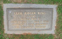
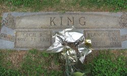
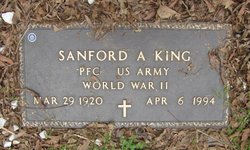
Cecil Roger King
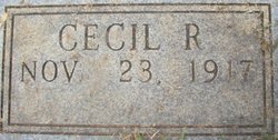
| Birth | : | 23 Nov 1917 Union County, South Carolina, USA |
| Death | : | 7 Aug 1999 Indian Land, Lancaster County, South Carolina, USA |
| Burial | : | Riceford Norwegian Cemetery, Riceford, Houston County, USA |
| Coordinate | : | 43.5755005, -91.7298965 |
| Inscription | : | US ARMY WORLD WAR II COMPANY I 23RD INFANTRY 2ND INFANTRY DIVISION |
| Description | : | ..News Article:::: The Charlotte Observer - Wednesday, August 11, 1999. Author: MELISSA MANWARE, Staff Writer * Contributor(s): Staff Writer MICHELE D. SNIPE contributed to this article. --CLUES MUDDLE PICTURE IN DEATH OF MAN, 81-- Why did someone fatally shoot an 81-year-old man who was dying of cancer? Why would robbers target his single-wide mobile home, then take some valuables and leave others? Lancaster County sheriff's deputies on Tuesday still were trying to answer those questions and others that might lead to whomever killed Cecil R. King. His son and daughter-in-law found his body early Sunday in the Henry Harris Road home they... Read More |
frequently asked questions (FAQ):
-
Where is Cecil Roger King's memorial?
Cecil Roger King's memorial is located at: Riceford Norwegian Cemetery, Riceford, Houston County, USA.
-
When did Cecil Roger King death?
Cecil Roger King death on 7 Aug 1999 in Indian Land, Lancaster County, South Carolina, USA
-
Where are the coordinates of the Cecil Roger King's memorial?
Latitude: 43.5755005
Longitude: -91.7298965
Family Members:
Parent

Spouse
Siblings

Flowers:


Nearby Cemetories:
1. Riceford Norwegian Cemetery
Riceford, Houston County, USA
Coordinate: 43.5755005, -91.7298965
2. Olde English Cemetery
Spring Grove, Houston County, USA
Coordinate: 43.5751600, -91.7294900
3. Scheie North Cemetery
Mabel, Fillmore County, USA
Coordinate: 43.6016998, -91.7797012
4. Scheie Lutheran Cemetery
Mabel, Fillmore County, USA
Coordinate: 43.5877040, -91.7894730
5. Saint Marys Cemetery
Fillmore County, USA
Coordinate: 43.6227989, -91.7407990
6. Mabel Cemetery
Mabel, Fillmore County, USA
Coordinate: 43.5292015, -91.7743988
7. Trinity Cemetery
Spring Grove, Houston County, USA
Coordinate: 43.5588740, -91.6497520
8. Newburg Methodist Church Cemetery
Newburg, Fillmore County, USA
Coordinate: 43.5686111, -91.8147202
9. Faith Lutheran Church Cemetery
Black Hammer, Houston County, USA
Coordinate: 43.6161118, -91.6597214
10. Garness Lutheran Church Cemetery
Mabel, Fillmore County, USA
Coordinate: 43.5444412, -91.8099976
11. Norwegian Ridge Cemetery
Spring Grove, Houston County, USA
Coordinate: 43.5619680, -91.6338300
12. South Fork Cemetery
Choice, Fillmore County, USA
Coordinate: 43.6522217, -91.7486115
13. Choice Community Cemetery
Choice, Fillmore County, USA
Coordinate: 43.6449370, -91.7883620
14. Hesper Public Cemetery
Winneshiek County, USA
Coordinate: 43.4840000, -91.7710000
15. Hesper Lutheran Cemetery
Hesper, Winneshiek County, USA
Coordinate: 43.4829250, -91.7673250
16. Highland Cemetery
Decorah, Winneshiek County, USA
Coordinate: 43.4892006, -91.6703033
17. Wisel Cemetery
Tawney, Fillmore County, USA
Coordinate: 43.6360817, -91.8432159
18. Swenson Farm Cemetery
Highland Township, Winneshiek County, USA
Coordinate: 43.4916368, -91.6223674
19. Hesper Pioneer Cemetery
Hesper, Winneshiek County, USA
Coordinate: 43.4610100, -91.7531000
20. Lenora Cemetery
Lenora, Fillmore County, USA
Coordinate: 43.5758018, -91.8899994
21. Prosper Cemetery
Canton, Fillmore County, USA
Coordinate: 43.5153008, -91.8675003
22. Egge Cemetery
Winneshiek County, USA
Coordinate: 43.4682999, -91.6600037
23. West Waterloo Ridge Cemetery
Quandahl, Allamakee County, USA
Coordinate: 43.4916371, -91.6001443
24. Yucatan Cemetery
Houston County, USA
Coordinate: 43.6946983, -91.6703033