

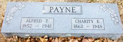
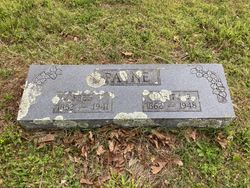
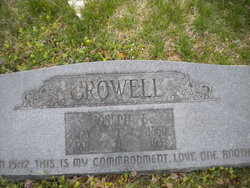
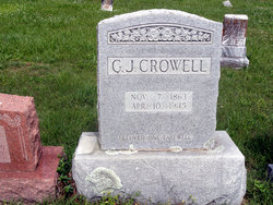
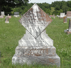
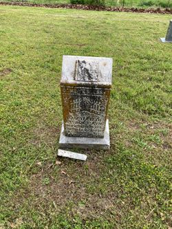
Charity Elizabeth Crowell Payne
| Birth | : | 18 Feb 1862 Tennessee, USA |
| Death | : | 2 Nov 1948 Koshkonong, Oregon County, Missouri, USA |
| Burial | : | Graceland Cemetery, Rowan, Wright County, USA |
| Coordinate | : | 42.7453003, -93.5714035 |
| Description | : | Daughter of Wiley Crowell and Sarah (Turner) Crowell. Married Alfred Pinkney Payne 04/Jun/1882 at Oregon Co., MO. |
frequently asked questions (FAQ):
-
Where is Charity Elizabeth Crowell Payne's memorial?
Charity Elizabeth Crowell Payne's memorial is located at: Graceland Cemetery, Rowan, Wright County, USA.
-
When did Charity Elizabeth Crowell Payne death?
Charity Elizabeth Crowell Payne death on 2 Nov 1948 in Koshkonong, Oregon County, Missouri, USA
-
Where are the coordinates of the Charity Elizabeth Crowell Payne's memorial?
Latitude: 42.7453003
Longitude: -93.5714035
Family Members:
Parent
Spouse
Siblings
Children
Flowers:


Nearby Cemetories:
1. Graceland Cemetery
Rowan, Wright County, USA
Coordinate: 42.7453003, -93.5714035
2. Galt Cemetery
Wright County, USA
Coordinate: 42.7030983, -93.5960999
3. Saint Francis Cemetery
Belmond, Wright County, USA
Coordinate: 42.8297005, -93.5905991
4. Belmond Cemetery
Belmond, Wright County, USA
Coordinate: 42.8360000, -93.6020000
5. Mount Hope Cemetery
Morgan Township, Franklin County, USA
Coordinate: 42.6777992, -93.4792023
6. Saint Johns Cemetery
Clarion, Wright County, USA
Coordinate: 42.7324982, -93.7039032
7. Evergreen Cemetery
Clarion, Wright County, USA
Coordinate: 42.7313995, -93.7069016
8. Alexander Cemetery
Alexander, Franklin County, USA
Coordinate: 42.8041687, -93.4591675
9. Fairview Cemetery
Dows, Wright County, USA
Coordinate: 42.6511002, -93.5044022
10. Immanuel Reformed Cemetery
Belmond, Wright County, USA
Coordinate: 42.8635000, -93.5484000
11. Holland Cemetery
Wisner Township, Franklin County, USA
Coordinate: 42.8638916, -93.4791718
12. Morgan Cemetery
Morgan Township, Franklin County, USA
Coordinate: 42.6741982, -93.4100037
13. Otis Grove Cemetery
Franklin County, USA
Coordinate: 42.6164017, -93.4880981
14. Saint Peter's Lutheran Church Cemetery
Coulter, Franklin County, USA
Coordinate: 42.7167015, -93.3803024
15. Olson Cemetery
Popejoy, Franklin County, USA
Coordinate: 42.6383018, -93.4403000
16. Coulter Cemetery
Coulter, Franklin County, USA
Coordinate: 42.7388916, -93.3716736
17. Saint Pauls Evangelical Lutheran Cemetery
Latimer, Franklin County, USA
Coordinate: 42.7652817, -93.3719406
18. Hickory Grove Cemetery
Wright County, USA
Coordinate: 42.8958015, -93.6421967
19. Vernon Township Lutheran Cemetery
Dows, Wright County, USA
Coordinate: 42.5864000, -93.5994000
20. Ringsaker Cemetery
Wright County, USA
Coordinate: 42.8636017, -93.7244034
21. Saint Olaf Lutheran Cemetery
Belmond, Wright County, USA
Coordinate: 42.8634000, -93.7317000
22. Saint Johns Lutheran Cemetery
Hampton, Franklin County, USA
Coordinate: 42.7197189, -93.3397217
23. Richard Cemetery
Meservey, Cerro Gordo County, USA
Coordinate: 42.9089012, -93.4925003
24. Simonson Family Cemetery
Belmond Township, Wright County, USA
Coordinate: 42.8999672, -93.6835466