


Charlene Pearl Jones Montgomery
| Birth | : | 21 Sep 1943 Neal, Greenwood County, Kansas, USA |
| Death | : | 26 Apr 1991 Greenwich Heights, Sedgwick County, Kansas, USA |
| Burial | : | Midway Church of Christ Cemetery, Bell, Gilchrist County, USA |
| Coordinate | : | 29.6938500, -82.9026200 |
| Plot | : | Block 2, Lot 2, Space 6 |
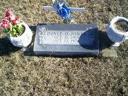
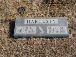
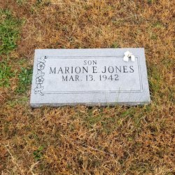
| Description | : | Charlene P. Montgomery, 47, died Friday April 26, 1991 as the result of a tornado. She was born September 21, 1948 at Neal to Doyle Jones and Olive Hamilton Jones. She was a group leader at Beech Aircraft in Wichita and had worked there for over 25 years. Survivors include two daughters, Terri Montgomery Kastner of Columbus, Ga., and Keri Lynn Montgomery of Wichita; two brothers, Marion Jones of Topeka and Herrold Jones of Toronto; mother and stepfather Olive and Glen Hardesty of Neal. Funeral services will be 10 a.m. Thursday, May 2, 1991 at the Downing & Lahey Mortuary in Wichita.... Read More |
frequently asked questions (FAQ):
-
Where is Charlene Pearl Jones Montgomery's memorial?
Charlene Pearl Jones Montgomery's memorial is located at: Midway Church of Christ Cemetery, Bell, Gilchrist County, USA.
-
When did Charlene Pearl Jones Montgomery death?
Charlene Pearl Jones Montgomery death on 26 Apr 1991 in Greenwich Heights, Sedgwick County, Kansas, USA
-
Where are the coordinates of the Charlene Pearl Jones Montgomery's memorial?
Latitude: 29.6938500
Longitude: -82.9026200
Family Members:
Parent
Spouse

Siblings

Flowers:


Nearby Cemetories:
1. Midway Church of Christ Cemetery
Bell, Gilchrist County, USA
Coordinate: 29.6938500, -82.9026200
2. Priscilla Baptist Church Cemetery
Bell, Gilchrist County, USA
Coordinate: 29.6927300, -82.8984600
3. Bethel Church of Christ Cemetery
Bell, Gilchrist County, USA
Coordinate: 29.7448100, -82.8915000
4. Log Landing Cemetery
Bell, Gilchrist County, USA
Coordinate: 29.7372500, -82.9392481
5. White Family Cemetery
Bell, Gilchrist County, USA
Coordinate: 29.7438430, -82.9307091
6. Fayetteville Cemetery
Old Town, Dixie County, USA
Coordinate: 29.7175007, -82.9617004
7. Jennings Lake Cemetery
Bell, Gilchrist County, USA
Coordinate: 29.6685150, -82.8427610
8. Pleasant Hill Baptist Church Cemetery
Bell, Gilchrist County, USA
Coordinate: 29.7232900, -82.8426200
9. Old McCrabb Cemetery
Old Town, Dixie County, USA
Coordinate: 29.6769009, -82.9721985
10. Bethel Cemetery
Trenton, Gilchrist County, USA
Coordinate: 29.6311700, -82.8985600
11. Bell Cemetery
Bell, Gilchrist County, USA
Coordinate: 29.7486170, -82.8660530
12. Sonshine Memorial Garden
Bell, Gilchrist County, USA
Coordinate: 29.7577410, -82.9030870
13. McCrabb Baptist Church and Cemetery
Old Town, Dixie County, USA
Coordinate: 29.7089996, -82.9850006
14. New Hope Family Church Cemetery
Bell, Gilchrist County, USA
Coordinate: 29.7671800, -82.8826200
15. Trenton Cemetery
Trenton, Gilchrist County, USA
Coordinate: 29.6281600, -82.8408620
16. Fowler Cemetery
Old Town, Dixie County, USA
Coordinate: 29.7483050, -82.9857110
17. Rock Sink Baptist Church Cemetery
Old Town, Dixie County, USA
Coordinate: 29.7813644, -82.9677658
18. Trenton Community Cemetery
Trenton, Gilchrist County, USA
Coordinate: 29.6303005, -82.8019028
19. Wayfair Cemetery
Bell, Gilchrist County, USA
Coordinate: 29.8069000, -82.8834600
20. Old Town Memorial Cemetery
Old Town, Dixie County, USA
Coordinate: 29.5893993, -82.9661026
21. Bard Property Cemetery
Bell, Gilchrist County, USA
Coordinate: 29.8188050, -82.9078195
22. Joppa Baptist Church Cemetery
Levy County, USA
Coordinate: 29.5687630, -82.8978220
23. Townsend Cemetery
Bell, Gilchrist County, USA
Coordinate: 29.8192005, -82.9013977
24. Shady Grove Cemetery
Dixie County, USA
Coordinate: 29.5802994, -82.9768982