


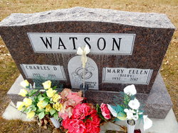
Charles Duane Watson
| Birth | : | 19 Jan 1933 Myers, Treasure County, Montana, USA |
| Death | : | 22 Apr 2011 Forsyth, Rosebud County, Montana, USA |
| Burial | : | Forsyth Cemetery, Forsyth, Rosebud County, USA |
| Coordinate | : | 46.2689018, -106.6528015 |
| Description | : | SOURCE: Death Certificate: ''''''''''''''''''''''''' The Billings Gazette, MT. 4/24/2011 Sunday Page 33 Charles D. Watson, age 78, passed away on April 22, 2011, at the Rosebud Healthcare Center in Forsyth, Montana. Charles was born on January 19, 1933, to Cleo and Anna Ludwig Watson in Meyers, Montana. Charles attended country school at Meyer West in Treasure Co, Montana. Charles married Mary Ellen Biery on April 8, 1953, in Miles City, Custer Co, Montana. Charles worked on the John Grierson Ranch, and later moved to the Forsyth and Colstrip areas. He worked for... Read More |
frequently asked questions (FAQ):
-
Where is Charles Duane Watson's memorial?
Charles Duane Watson's memorial is located at: Forsyth Cemetery, Forsyth, Rosebud County, USA.
-
When did Charles Duane Watson death?
Charles Duane Watson death on 22 Apr 2011 in Forsyth, Rosebud County, Montana, USA
-
Where are the coordinates of the Charles Duane Watson's memorial?
Latitude: 46.2689018
Longitude: -106.6528015
Family Members:
Parent

Spouse
Siblings

Flowers:


Nearby Cemetories:
1. Forsyth Cemetery
Forsyth, Rosebud County, USA
Coordinate: 46.2689018, -106.6528015
2. Rosebud Cemetery
Rosebud, Rosebud County, USA
Coordinate: 46.2689018, -106.4381027
3. Howard Cemetery
Rosebud County, USA
Coordinate: 46.2621994, -106.9222031
4. Hathaway Cemetery
Rosebud County, USA
Coordinate: 46.2616997, -106.2185974
5. Colstrip Cemetery
Colstrip, Rosebud County, USA
Coordinate: 45.9096985, -106.6194000
6. Memorial Vale Cemetery
Hysham, Treasure County, USA
Coordinate: 46.2552986, -107.2307968
7. Bean Cemetery
Rosebud County, USA
Coordinate: 45.8535995, -106.4011002
8. Brown Cemetery
Colstrip, Rosebud County, USA
Coordinate: 45.8321991, -106.4180984
9. Lee Cemetery
Rosebud County, USA
Coordinate: 45.7792015, -106.5413971
10. Rancher Cemetery
Myers, Treasure County, USA
Coordinate: 46.2580986, -107.4197006
11. Fort Keogh Cemetery
Custer County, USA
Coordinate: 46.3800011, -105.8874969
12. Vanstel Cemetery
Rosebud County, USA
Coordinate: 46.7872009, -106.8942032
13. Calvary Cemetery
Miles City, Custer County, USA
Coordinate: 46.3816986, -105.8249969
14. Eastern Montana State Veterans Cemetery
Miles City, Custer County, USA
Coordinate: 46.3807564, -105.8246536
15. Old Calvary Cemetery
Miles City, Custer County, USA
Coordinate: 46.3807600, -105.8246500
16. Custer County Cemetery
Miles City, Custer County, USA
Coordinate: 46.3891983, -105.8264008
17. Pine Hills School Cemetery
Miles City, Custer County, USA
Coordinate: 46.4077988, -105.8167038
18. Rock Springs Cemetery
Rock Springs, Rosebud County, USA
Coordinate: 46.7847800, -106.1411500
19. Pine Crest Cemetery
Custer County, USA
Coordinate: 46.4564018, -105.7789001
20. Junction City Cemetery
Yellowstone County, USA
Coordinate: 46.1437320, -107.5493300
21. Lame Deer Cemetery
Lame Deer, Rosebud County, USA
Coordinate: 45.6264000, -106.6619034
22. Custer Cemetery
Custer, Yellowstone County, USA
Coordinate: 46.1270690, -107.5700030
23. Muddy Creek Cemetery
Muddy, Big Horn County, USA
Coordinate: 45.5741997, -106.7406006
24. Saint Labre Cemetery
Ashland, Rosebud County, USA
Coordinate: 45.6070930, -106.2836910