
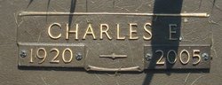
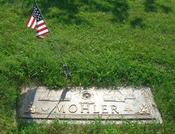
Charles E. Mohler
| Birth | : | 23 Mar 1920 USA |
| Death | : | 28 Feb 2005 Lancaster, Fairfield County, Ohio, USA |
| Burial | : | Schurz Paiute Indian Cemetery, Schurz, Mineral County, USA |
| Coordinate | : | 38.9740982, -118.8443985 |
| Description | : | Charles E. Mohler, 84, of Lancaster, Ohio, passed away Monday, February 28, 2005, at Fairfield Medical Center. Charles was a member of Grace United Church of Christ, Olivedale Senior Golf League, Lancaster High School Class of 1938 and School Colors were Purple and Gold, US Navy Veteran and was retired after 42 years from Anchor Hocking plant 2 Lancaster, Ohio. He is survived by his wife, Anna M. "Peggy" (Mallory) Mohler, of Lancaster, Ohio; daughters, Jacquelyn M. (Reginald) Warner of Lancaster, Ohio, Bonnie J. (Rick) Mazza, Clarksburg, Virginia; grandchildren,, Eric W. (Lee Anne) Neal, Burlington, North Carolina, Angela Dosler, Gibsonville, North Carolina,... Read More |
frequently asked questions (FAQ):
-
Where is Charles E. Mohler's memorial?
Charles E. Mohler's memorial is located at: Schurz Paiute Indian Cemetery, Schurz, Mineral County, USA.
-
When did Charles E. Mohler death?
Charles E. Mohler death on 28 Feb 2005 in Lancaster, Fairfield County, Ohio, USA
-
Where are the coordinates of the Charles E. Mohler's memorial?
Latitude: 38.9740982
Longitude: -118.8443985
Family Members:
Parent

Siblings

Flowers:


Nearby Cemetories:
1. Schurz Paiute Indian Cemetery
Schurz, Mineral County, USA
Coordinate: 38.9740982, -118.8443985
2. Valley View Cemetery
Yerington, Lyon County, USA
Coordinate: 38.9643593, -119.1384888
3. Yerington Paiute Memorial Cemetery
Yerington, Lyon County, USA
Coordinate: 38.9367900, -119.1924100
4. Elm Tree Cemetery
Yerington, Lyon County, USA
Coordinate: 38.8274994, -119.1682968
5. Virginia Mahon Gravesite
Walker Lake, Mineral County, USA
Coordinate: 38.6531300, -118.7615500
6. Rawhide Cemetery
Mineral County, USA
Coordinate: 39.0424995, -118.4019012
7. Pine Grove Cemetery
Pine Grove, Lyon County, USA
Coordinate: 38.6825000, -119.1255000
8. Wrightman Ranch Cemetery
Fallon, Churchill County, USA
Coordinate: 39.2026000, -118.4540000
9. Valley Grove Cemetery
Smith, Lyon County, USA
Coordinate: 38.8020510, -119.3383030
10. Saint Marys Episcopal Church Cemetery
Nixon, Washoe County, USA
Coordinate: 38.8329910, -119.3573040
11. Hillcrest Cemetery
Smith, Lyon County, USA
Coordinate: 38.7867012, -119.3343964
12. Turner Grave Site
Churchill County, USA
Coordinate: 39.2915479, -118.4477394
13. Saint Clair Cemetery
Fallon, Churchill County, USA
Coordinate: 39.4150009, -118.7782974
14. Allen Road Cemetery
Fallon, Churchill County, USA
Coordinate: 39.4275000, -118.8000000
15. Fort Churchill Cemetery
Lyon County, USA
Coordinate: 39.2956009, -119.2667007
16. Everett Family Cemetery
Wellington, Lyon County, USA
Coordinate: 38.7844880, -119.3903490
17. Hawthorne Cemetery
Hawthorne, Mineral County, USA
Coordinate: 38.5340004, -118.6253967
18. Chinese Cemetery
Hawthorne, Mineral County, USA
Coordinate: 38.5334300, -118.6144800
19. Poinsettia Burial Ground
Hawthorne, Mineral County, USA
Coordinate: 38.7787400, -118.2624100
20. Holy Trinity Episcopal Church Columbarium
Fallon, Churchill County, USA
Coordinate: 39.4701760, -118.7755950
21. Rosewood Drive Cemetery
Fallon, Churchill County, USA
Coordinate: 39.4731400, -118.8431100
22. Gardens Cemetery
Fallon, Churchill County, USA
Coordinate: 39.4751000, -118.7234000
23. Churchill County Cemetery
Fallon, Churchill County, USA
Coordinate: 39.4812900, -118.7518500
24. McMichael Family Cemetery
Douglas County, USA
Coordinate: 38.7380900, -119.4315700