

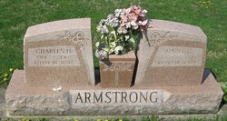
Charles H Armstrong
| Birth | : | 1901 Indiana, USA |
| Death | : | 27 Dec 1968 Sullivan, Sullivan County, Indiana, USA |
| Burial | : | St. Mary's Churchyard, Tickhill, Metropolitan Borough of Doncaster, England |
| Coordinate | : | 53.4309200, -1.1112200 |
| Plot | : | Section 11 |
| Inscription | : | Asleep in Jesus |
| Description | : | Terre Haute Tribune, Terre Haute, IN, Saturday, 28 Dec 1968, Page 2 CHARLES H. ARMSTRONG / SULLIVAN, Ind. (Special) - Charles H. Armstrong, 67, RR 3, died at 12:45 p.m. Friday at the Mary Sherman Hospital. He is survived by a son, Paul, Sullivan; two brothers, Fred and Harry, both of Terre Haute; a sister, Mrs. Jane Crume, Terre Haute; a step-sister, Mrs. Vera Ray, Indianapolis, and four grandchildren. Services will be at 2 p.m. Sunday at the Alexander Funeral Home, with the Rev. Claude Walters officiating. Burial will be in the Center Ridge Cemetery.... Read More |
frequently asked questions (FAQ):
-
Where is Charles H Armstrong's memorial?
Charles H Armstrong's memorial is located at: St. Mary's Churchyard, Tickhill, Metropolitan Borough of Doncaster, England.
-
When did Charles H Armstrong death?
Charles H Armstrong death on 27 Dec 1968 in Sullivan, Sullivan County, Indiana, USA
-
Where are the coordinates of the Charles H Armstrong's memorial?
Latitude: 53.4309200
Longitude: -1.1112200
Family Members:
Parent
Spouse
Siblings
Children
Flowers:


Nearby Cemetories:
1. St. Mary's Churchyard
Tickhill, Metropolitan Borough of Doncaster, England
Coordinate: 53.4309200, -1.1112200
2. Saint Mary's Cemetery
Tickhill, Metropolitan Borough of Doncaster, England
Coordinate: 53.4315867, -1.1108661
3. Austin Friars Churchyard
Tickhill, Metropolitan Borough of Doncaster, England
Coordinate: 53.4283270, -1.1194740
4. Tickhill Friary
Tickhill, Metropolitan Borough of Doncaster, England
Coordinate: 53.4283330, -1.1195830
5. Styrrup Road Cemetery
Harworth, Bassetlaw District, England
Coordinate: 53.4160400, -1.0816770
6. All Saints Churchyard
Harworth, Bassetlaw District, England
Coordinate: 53.4187800, -1.0781900
7. Harworth Cemetery
Harworth, Bassetlaw District, England
Coordinate: 53.4185060, -1.0733460
8. Sandbeck Park
Maltby, Metropolitan Borough of Rotherham, England
Coordinate: 53.4061450, -1.1460050
9. St Winifred Churchyard
Stainton, Metropolitan Borough of Doncaster, England
Coordinate: 53.4367385, -1.1657988
10. St Helen's Roman Catholic Churchyard
Nottingham, Nottingham Unitary Authority, England
Coordinate: 53.3903220, -1.1131860
11. St. John the Baptist Churchyard
Wadworth, Metropolitan Borough of Doncaster, England
Coordinate: 53.4673170, -1.1447000
12. Rossington Cemetery
Rossington, Metropolitan Borough of Doncaster, England
Coordinate: 53.4704340, -1.0896950
13. Rossington Grange Lane Cemetery
New Rossington, Metropolitan Borough of Doncaster, England
Coordinate: 53.4705000, -1.0897200
14. St. Martin Churchyard
Firbeck, Metropolitan Borough of Rotherham, England
Coordinate: 53.3900080, -1.1561770
15. Maltby Cemetery
Maltby, Metropolitan Borough of Rotherham, England
Coordinate: 53.4255480, -1.1960280
16. Roche Abbey
Maltby, Metropolitan Borough of Rotherham, England
Coordinate: 53.4025000, -1.1834000
17. Respect Green Burial Park
Bawtry, Metropolitan Borough of Doncaster, England
Coordinate: 53.4200210, -1.0250520
18. St. Katherine Churchyard
Loversall, Metropolitan Borough of Doncaster, England
Coordinate: 53.4821700, -1.1333650
19. Langold Cemetery
Worksop, Bassetlaw District, England
Coordinate: 53.3777600, -1.1170100
20. St Nicholas Chapel of All Souls Ancillary Cemetery
Bawtry, Metropolitan Borough of Doncaster, England
Coordinate: 53.4344798, -1.0211632
21. Bawtry Cemetery
Bawtry, Metropolitan Borough of Doncaster, England
Coordinate: 53.4341255, -1.0192066
22. St. Nicholas' Churchyard
Bawtry, Metropolitan Borough of Doncaster, England
Coordinate: 53.4297900, -1.0183400
23. St. Michael's Churchyard
Rossington, Metropolitan Borough of Doncaster, England
Coordinate: 53.4782772, -1.0596305
24. St. James' Churchyard
Braithwell, Metropolitan Borough of Doncaster, England
Coordinate: 53.4465700, -1.2035400