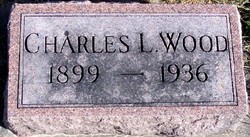
Charles L. Wood
| Birth | : | 1899 Bloomfield, Knox County, Nebraska, USA |
| Death | : | 8 May 1936 Cherokee County, Iowa, USA |
| Burial | : | Fork Ridge Universalist Cemetery, Glen Easton, Marshall County, USA |
| Coordinate | : | 39.8689003, -80.6408005 |
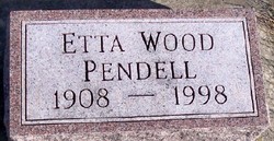
| Description | : | Married Etta M. Dawson in 1927. Obit: Spring Township Man Found Dead Near Residence. Was Either Kicked or Caught Under Animal. World War Vet. Funeral Services Will Be Held Sunday Afternoon. Charles Wood, tenant farmer on the Mrs. Mae Clark farm in Spring Township, was instantly killed Friday when his heart was crushed by one horse of a team he was leading to water. Whether the horse kicked him in the face and chest or whether the animal fell on him is not known. According to Mrs. Clark, Mrs. Wood saw her husband lying on... Read More |
frequently asked questions (FAQ):
-
Where is Charles L. Wood's memorial?
Charles L. Wood's memorial is located at: Fork Ridge Universalist Cemetery, Glen Easton, Marshall County, USA.
-
When did Charles L. Wood death?
Charles L. Wood death on 8 May 1936 in Cherokee County, Iowa, USA
-
Where are the coordinates of the Charles L. Wood's memorial?
Latitude: 39.8689003
Longitude: -80.6408005
Family Members:
Parent
Spouse
Siblings
Flowers:
Nearby Cemetories:
1. Fork Ridge Universalist Cemetery
Glen Easton, Marshall County, USA
Coordinate: 39.8689003, -80.6408005
2. Fork Ridge Christian Cemetery
Marshall County, USA
Coordinate: 39.8686690, -80.6405370
3. Fork Ridge Cemetery
Moundsville, Marshall County, USA
Coordinate: 39.8675003, -80.6331024
4. Brushy Ridge Cemetery
Marshall County, USA
Coordinate: 39.8602982, -80.6472015
5. Harris Cemetery
Marshall County, USA
Coordinate: 39.8703003, -80.6616974
6. Rulong-Bartlett Cemetery
Marshall County, USA
Coordinate: 39.8678017, -80.6781006
7. Hubbs Cemetery
Marshall County, USA
Coordinate: 39.8502998, -80.6093979
8. Davis Cemetery
Marshall County, USA
Coordinate: 39.8558006, -80.6778030
9. Easton Cemetery
Glen Easton, Marshall County, USA
Coordinate: 39.8354250, -80.6470380
10. Blairs Ridge Cemetery
Moundsville, Marshall County, USA
Coordinate: 39.9033012, -80.6477966
11. Fork Ridge Baptist Cemetery
Glen Easton, Marshall County, USA
Coordinate: 39.8717003, -80.5907974
12. Beeler Station Cemetery
Moundsville, Marshall County, USA
Coordinate: 39.8838997, -80.5911026
13. New Bethel Church Cemetery
Marshall County, USA
Coordinate: 39.8246994, -80.6624985
14. Pleasant Valley Cemetery
Limestone, Marshall County, USA
Coordinate: 39.9178009, -80.6292038
15. Salem Cemetery
Glen Easton, Marshall County, USA
Coordinate: 39.8217010, -80.6688995
16. Oak Grove Cemetery
Moundsville, Marshall County, USA
Coordinate: 39.8774986, -80.7078018
17. Bowman Cemetery
Glen Easton, Marshall County, USA
Coordinate: 39.8272018, -80.6883011
18. Martin Family Cemetery
Pleasant Valley, Marshall County, USA
Coordinate: 39.9167000, -80.6030000
19. Buchanan Hill Cemetery
Marshall County, USA
Coordinate: 39.9258003, -80.6427994
20. Bane Cemetery
Marshall County, USA
Coordinate: 39.8731003, -80.5639038
21. Crow Family Cemetery
Marshall County, USA
Coordinate: 39.9289000, -80.6263500
22. White Gate Cemetery
Moundsville, Marshall County, USA
Coordinate: 39.9091988, -80.7016983
23. Wolf Run Cemetery
Pleasant Valley, Marshall County, USA
Coordinate: 39.9141998, -80.5843964
24. Wolf Run Presbyterian Cemetery
Pleasant Valley, Marshall County, USA
Coordinate: 39.9140630, -80.5840340


