
| Birth | : | 8 Mar 1901 Rooks County, Kansas, USA |
| Death | : | 6 May 1988 San Joaquin County, California, USA |
| Burial | : | Burwood Cemetery, Escalon, San Joaquin County, USA |
| Coordinate | : | 37.7616997, -120.9593964 |
| Plot | : | Garden of Memories . Blk 1326 . Sp 6 |
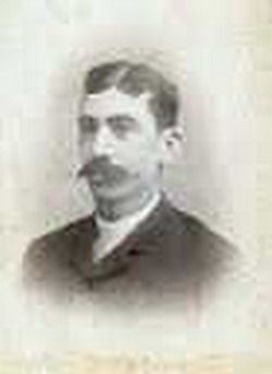
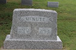
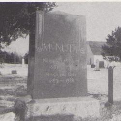
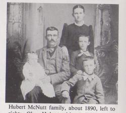
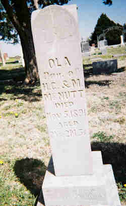
| Description | : | Charles McNutt was born to Huber C and Mary McNutt in Woodston Ks. He married Edna Davis and they moved to Chalifornia. She died in 1971 and Charlie married Edna Rose Leahy Hamilton McNutt. She passed away in 1981. The children of Charlie and Edna Davis were Marceline, Barbara Jean, Charlene. Hubert his father was living with the family in 1940. Burwood cemetery is an assumption as his 2nd wife is here. |
frequently asked questions (FAQ):
-
Where is Charles Lester “Charlie” McNutt's memorial?
Charles Lester “Charlie” McNutt's memorial is located at: Burwood Cemetery, Escalon, San Joaquin County, USA.
-
When did Charles Lester “Charlie” McNutt death?
Charles Lester “Charlie” McNutt death on 6 May 1988 in San Joaquin County, California, USA
-
Where are the coordinates of the Charles Lester “Charlie” McNutt's memorial?
Latitude: 37.7616997
Longitude: -120.9593964
Family Members:
Parent
Spouse

Siblings
Children
Flowers:


Nearby Cemetories:
1. Burwood Cemetery
Escalon, San Joaquin County, USA
Coordinate: 37.7616997, -120.9593964
2. Langworth Cemetery
Oakdale, Stanislaus County, USA
Coordinate: 37.7580986, -120.8957977
3. Valley Home Memorial Park
Oakdale, Stanislaus County, USA
Coordinate: 37.8275528, -120.9333267
4. Oaklawn Memorial Park
Oakdale, Stanislaus County, USA
Coordinate: 37.7711945, -120.8486862
5. Oakdale Citizens Cemetery
Oakdale, Stanislaus County, USA
Coordinate: 37.7624600, -120.8388800
6. Saint John's Catholic Cemetery
Escalon, San Joaquin County, USA
Coordinate: 37.7994537, -121.0705185
7. Wood Colony Cemetery
Salida, Stanislaus County, USA
Coordinate: 37.6893730, -121.0682144
8. Modesto County Cemetery
Modesto, Stanislaus County, USA
Coordinate: 37.6492400, -120.9813800
9. Good Shepherd Catholic Cemetery
Modesto, Stanislaus County, USA
Coordinate: 37.6853130, -121.0672890
10. Acacia Memorial Park
Modesto, Stanislaus County, USA
Coordinate: 37.6481080, -120.9836610
11. Saint Stanislaus Catholic Cemetery
Modesto, Stanislaus County, USA
Coordinate: 37.6473610, -120.9808440
12. Modesto Pioneer Cemetery
Modesto, Stanislaus County, USA
Coordinate: 37.6473350, -120.9829040
13. Modesto Citizens Cemetery
Modesto, Stanislaus County, USA
Coordinate: 37.6472930, -120.9845570
14. Ripon Cemetery
Ripon, San Joaquin County, USA
Coordinate: 37.7420311, -121.1238708
15. Lakewood Memorial Park
Hughson, Stanislaus County, USA
Coordinate: 37.6199760, -120.8975983
16. Saint Joseph Cemetery
Eugene, Stanislaus County, USA
Coordinate: 37.8941994, -120.8696976
17. Old Brooks Farm Cemetery
Farmington, San Joaquin County, USA
Coordinate: 37.9175800, -120.9440300
18. Atlanta Cemetery
Five Corners, San Joaquin County, USA
Coordinate: 37.8270035, -121.1420135
19. Highland View Memorial Gardens
Farmington, San Joaquin County, USA
Coordinate: 37.9242935, -121.0008621
20. Ceres Memorial Park
Ceres, Stanislaus County, USA
Coordinate: 37.5958214, -120.9634399
21. Martin Cemetery
Waterford, Stanislaus County, USA
Coordinate: 37.6684360, -120.7582160
22. Collegeville Cemetery
Collegeville, San Joaquin County, USA
Coordinate: 37.9044800, -121.1466141
23. East Union Cemetery
Manteca, San Joaquin County, USA
Coordinate: 37.8114014, -121.2350006
24. Knights Ferry Cemetery
Stanislaus County, USA
Coordinate: 37.8224907, -120.6830750