
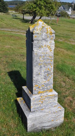
Charles McLellan
| Birth | : | 1816 |
| Death | : | 1892 |
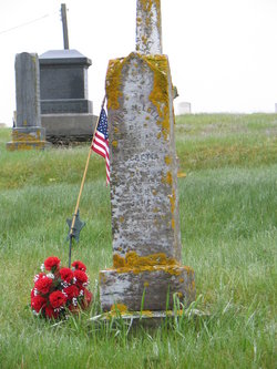
| Burial | : | Castle Hill Cemetery, Castle Hill, Aroostook County, USA |
| Coordinate | : | 46.7346840, -68.1792210 |
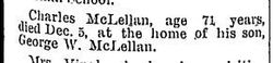
| Description | : | Name: Charles McLellan Gender: Male Death Date: 5 Dec 1892 Death Place: Castle Hill, Aroostook, Maine, USA Father: James McLellan Mother: Lucretia McLellan Charles is the first identified child of James and Lucretia We do see in the 1840 census they had 14 children and there is a note in Mclellan family logs that it may have been 20-22 |
frequently asked questions (FAQ):
-
Where is Charles McLellan's memorial?
Charles McLellan's memorial is located at: Castle Hill Cemetery, Castle Hill, Aroostook County, USA.
-
When did Charles McLellan death?
Charles McLellan death on 1892 in
-
Where are the coordinates of the Charles McLellan's memorial?
Latitude: 46.7346840
Longitude: -68.1792210
Family Members:
Parent

Siblings


Flowers:


Nearby Cemetories:
1. Castle Hill Cemetery
Castle Hill, Aroostook County, USA
Coordinate: 46.7346840, -68.1792210
2. Washburn Riverside Extension Cemetery
Washburn, Aroostook County, USA
Coordinate: 46.7750816, -68.1517105
3. Riverside Cemetery
Washburn, Aroostook County, USA
Coordinate: 46.7785492, -68.1552277
4. Old Mill Town Cemetery
Mapleton, Aroostook County, USA
Coordinate: 46.6815700, -68.1609100
5. Southside Cemetery
Mapleton, Aroostook County, USA
Coordinate: 46.6622050, -68.1633620
6. Hillside Grove Cemetery
Crouseville, Aroostook County, USA
Coordinate: 46.7566760, -68.0765500
7. Crouseville Cemetery
Crouseville, Aroostook County, USA
Coordinate: 46.7574997, -68.0768967
8. Tarr Cemetery
Castle Hill, Aroostook County, USA
Coordinate: 46.6664200, -68.2203800
9. Alley Cemetery
Ashland, Aroostook County, USA
Coordinate: 46.7014730, -68.3049090
10. Grendell Cemetery
Chapman, Aroostook County, USA
Coordinate: 46.6364010, -68.1318340
11. Johnson Cemetery
Presque Isle, Aroostook County, USA
Coordinate: 46.7078209, -68.0069733
12. Saint Marys Cemetery
Presque Isle, Aroostook County, USA
Coordinate: 46.6930930, -68.0104730
13. Saint Marys Chapman Street Cemetery
Presque Isle, Aroostook County, USA
Coordinate: 46.6754150, -68.0215990
14. Frenchville Catholic Cemetery
Ashland, Aroostook County, USA
Coordinate: 46.6779740, -68.3398050
15. Fairview Cemetery
Perham, Aroostook County, USA
Coordinate: 46.8666992, -68.2086029
16. Fairmount Cemetery
Presque Isle, Aroostook County, USA
Coordinate: 46.6628075, -68.0077744
17. Lyndon Center Cemetery
Caribou, Aroostook County, USA
Coordinate: 46.8022240, -67.9921920
18. Gardner Memorial Cemetery
Ashland, Aroostook County, USA
Coordinate: 46.6566300, -68.3577430
19. Bartlett Cemetery
Presque Isle, Aroostook County, USA
Coordinate: 46.6765327, -67.9827118
20. Northern Maine Veterans Cemetery
Caribou, Aroostook County, USA
Coordinate: 46.8512400, -68.0428500
21. Bean Family Cemetery
Aroostook County, USA
Coordinate: 46.7396440, -67.9542600
22. Thompson Burial Ground
Caribou, Aroostook County, USA
Coordinate: 46.8143280, -67.9821140
23. Reuben Bean Family Cemetery
Aroostook County, USA
Coordinate: 46.7141610, -67.9514610
24. Evergreen Cemetery
Caribou, Aroostook County, USA
Coordinate: 46.8524500, -68.0112700