

Charles O Taylor
| Birth | : | 5 Mar 1885 Oregon County, Missouri, USA |
| Death | : | 13 Sep 1885 Oregon County, Missouri, USA |
| Burial | : | St. Mary and St. Cuthbert Priory Churchyard, Bolton Abbey, Craven District, England |
| Coordinate | : | 53.9825000, -1.8872220 |
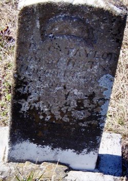
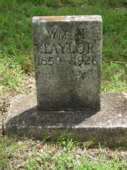
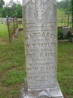
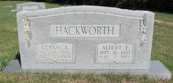
| Description | : | Son of William T Taylor & Margaret Taylor∼This is where Charles is buried in Myrtle Cemetery, Myrtle, Oregon County, Missouri. The tombstone listing C O, |
frequently asked questions (FAQ):
-
Where is Charles O Taylor's memorial?
Charles O Taylor's memorial is located at: St. Mary and St. Cuthbert Priory Churchyard, Bolton Abbey, Craven District, England.
-
When did Charles O Taylor death?
Charles O Taylor death on 13 Sep 1885 in Oregon County, Missouri, USA
-
Where are the coordinates of the Charles O Taylor's memorial?
Latitude: 53.9825000
Longitude: -1.8872220
Family Members:
Parent
Siblings


Nearby Cemetories:
1. St. Mary and St. Cuthbert Priory Churchyard
Bolton Abbey, Craven District, England
Coordinate: 53.9825000, -1.8872220
2. St Peter Churchyard
Addingham, Metropolitan Borough of Bradford, England
Coordinate: 53.9433200, -1.8720200
3. St Mary Churchyard
Embsay, Craven District, England
Coordinate: 53.9829390, -1.9834030
4. All Saints Churchyard
Ilkley, Metropolitan Borough of Bradford, England
Coordinate: 53.9267050, -1.8241970
5. Ilkley War Memorial
Ilkley, Metropolitan Borough of Bradford, England
Coordinate: 53.9246070, -1.8288130
6. Ilkley Cemetery
Ilkley, Metropolitan Borough of Bradford, England
Coordinate: 53.9304820, -1.8133870
7. St Margaret Churchyard
Ilkley, Metropolitan Borough of Bradford, England
Coordinate: 53.9209950, -1.8269930
8. St James Churchyard
Silsden, Metropolitan Borough of Bradford, England
Coordinate: 53.9139070, -1.9390650
9. Silsden Cemetery
Silsden, Metropolitan Borough of Bradford, England
Coordinate: 53.9106500, -1.9267000
10. St Wilfrid Churchyard
Burnsall, Craven District, England
Coordinate: 54.0495000, -1.9520690
11. St. Andrew's Churchyard
Skipton, Craven District, England
Coordinate: 53.9609959, -2.0140994
12. St Helen Churchyard
Denton, Harrogate Borough, England
Coordinate: 53.9360940, -1.7808630
13. Holy Trinity Churchyard
Skipton, Craven District, England
Coordinate: 53.9633250, -2.0161180
14. Skipton War Memorial
Skipton, Craven District, England
Coordinate: 53.9627100, -2.0161680
15. Friends Burial Ground at Skipton
Skipton, Craven District, England
Coordinate: 53.9599220, -2.0148630
16. Bradley Cemetery
Bradleys Both, Craven District, England
Coordinate: 53.9306747, -1.9907120
17. Raikes Road Burial Ground
Skipton, Craven District, England
Coordinate: 53.9643822, -2.0196819
18. St Stephen Roman Catholic Churchyard
Skipton, Craven District, England
Coordinate: 53.9631760, -2.0210240
19. Christ Churchyard
Skipton, Craven District, England
Coordinate: 53.9581200, -2.0188910
20. Tarn Moor Memorial Woodland Burial Ground
Skipton, Craven District, England
Coordinate: 53.9759590, -2.0254260
21. St Andrew Churchyard
Blubberhouses, Harrogate Borough, England
Coordinate: 53.9932200, -1.7455200
22. Holy Trinity Cemetery
Thruscross, Harrogate Borough, England
Coordinate: 54.0259440, -1.7646110
23. Waltonwrays Cemetery and Skipton Crematorium
Skipton, Craven District, England
Coordinate: 53.9505500, -2.0272300
24. St Peter Churchyard
Hebden, Craven District, England
Coordinate: 54.0626500, -1.9618960