
| Birth | : | 10 Feb 1873 |
| Death | : | 19 Jun 1955 Colville, Stevens County, Washington, USA |
| Burial | : | Forest Home Cemetery, Northport, Stevens County, USA |
| Coordinate | : | 48.8955994, -117.7388992 |
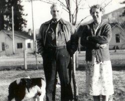
| Description | : | Charles was the first child of Susan Evaline Agnew and Jacob Sell. Charles married Mary Angeline Anders in Indiana. Mary is buried here in Forest Home Cemetery as "Mrs. Chas. SEll". Mary's and Charles' children, George Eldred Sell, Leonard Lawrence Sell, Mary Faye Sell and Charles' father, Jacob Sell too are all buried here in Forest Home Cemetery. |
frequently asked questions (FAQ):
-
Where is Charles Sell's memorial?
Charles Sell's memorial is located at: Forest Home Cemetery, Northport, Stevens County, USA.
-
When did Charles Sell death?
Charles Sell death on 19 Jun 1955 in Colville, Stevens County, Washington, USA
-
Where are the coordinates of the Charles Sell's memorial?
Latitude: 48.8955994
Longitude: -117.7388992
Family Members:
Parent

Spouse
Siblings
Children
Flowers:


Nearby Cemetories:
1. Forest Home Cemetery
Northport, Stevens County, USA
Coordinate: 48.8955994, -117.7388992
2. Riverview Cemetery
Northport, Stevens County, USA
Coordinate: 48.8958015, -117.8031006
3. Boundary Cemetery
Northport, Stevens County, USA
Coordinate: 48.9974900, -117.6293200
4. Pend'Oreille Cemetery
Trail, Kootenay Boundary Regional District, Canada
Coordinate: 49.0064500, -117.6037500
5. Calvary Catholic Cemetery
Rossland, Kootenay Boundary Regional District, Canada
Coordinate: 49.0715700, -117.7931900
6. Mountain View Cemetery
Trail, Kootenay Boundary Regional District, Canada
Coordinate: 49.0756500, -117.7818900
7. Old Trail Cemetery
Trail, Kootenay Boundary Regional District, Canada
Coordinate: 49.0773200, -117.7761000
8. Columbia Cemetery
Rossland, Kootenay Boundary Regional District, Canada
Coordinate: 49.0798540, -117.7841230
9. Columbia Riverview Cemetery
Trail, Kootenay Boundary Regional District, Canada
Coordinate: 49.0976200, -117.6678700
10. Metaline Cemetery
Metaline, Pend Oreille County, USA
Coordinate: 48.8546295, -117.3930435
11. Perkins Family Cemetery
Metaline, Pend Oreille County, USA
Coordinate: 48.8418999, -117.3835983
12. Fruitvale Memorial Cemetery
Fruitvale, Kootenay Boundary Regional District, Canada
Coordinate: 49.1063200, -117.5487500
13. Bossburg Cemetery
Stevens County, USA
Coordinate: 48.7435989, -118.0485992
14. Pia Mission Cemetery
Stevens County, USA
Coordinate: 48.7960700, -118.1097300
15. Kelly Hill Cemetery
Stevens County, USA
Coordinate: 48.8130989, -118.1268997
16. Riverside Cemetery
Ione, Pend Oreille County, USA
Coordinate: 48.7213593, -117.4130096
17. Harvey Gravesite
Pend Oreille County, USA
Coordinate: 48.9555100, -117.3152300
18. River View Cemetery
Marcus, Stevens County, USA
Coordinate: 48.6690300, -118.0404400
19. Green Mountain Cemetery
Stevens County, USA
Coordinate: 48.7200180, -118.1178760
20. Orient Cemetery
Orient, Ferry County, USA
Coordinate: 48.8578987, -118.2032013
21. Meredith Homestead Cemetery
Tiger, Pend Oreille County, USA
Coordinate: 48.6319440, -117.4952780
22. Laurier Cemetery
Ferry County, USA
Coordinate: 48.9855500, -118.2189000
23. Fort Colville Post Cemetery
Stevens County, USA
Coordinate: 48.5722270, -117.8789230
24. Cascade Cemetery
Cascade, Kootenay Boundary Regional District, Canada
Coordinate: 49.0188990, -118.2247300