

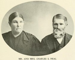
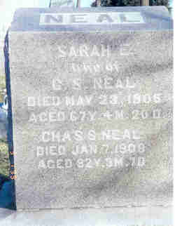
Charles Smith Neal
| Birth | : | 1 Oct 1825 Gallipolis, Gallia County, Ohio, USA |
| Death | : | 7 Jan 1908 Maryville, Nodaway County, Missouri, USA |
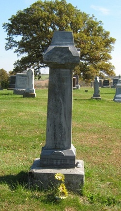
| Burial | : | Union Cemetery, Leesburg, Loudoun County, USA |
| Coordinate | : | 39.1204600, -77.5623700 |
| Plot | : | Northwest (5) Row 24 |
| Description | : | Son of Henry Neal and Sarah Maddy Neal. Republican - Thursday, January 9, 1908 Charles S. Neal, 82 years old one of the earliest settlers in Nodaway county died at six o'clock Tuesday morning at his home on South Vine street after a short illness with pneumonia. Mr. Neal came to Nodaway county in 1854 and until 3 years ago lived on a farm near this city. About the only persons who were living at Maryville at the time of his coming to this county and who still survive are Geo. Baker, Andy Stinson, and James Saunders. When the Civil War... Read More |
frequently asked questions (FAQ):
-
Where is Charles Smith Neal's memorial?
Charles Smith Neal's memorial is located at: Union Cemetery, Leesburg, Loudoun County, USA.
-
When did Charles Smith Neal death?
Charles Smith Neal death on 7 Jan 1908 in Maryville, Nodaway County, Missouri, USA
-
Where are the coordinates of the Charles Smith Neal's memorial?
Latitude: 39.1204600
Longitude: -77.5623700
Family Members:
Parent
Spouse
Siblings

Children
Flowers:


Nearby Cemetories:
1. Union Cemetery
Leesburg, Loudoun County, USA
Coordinate: 39.1204600, -77.5623700
2. Saint John the Apostle Catholic Cemetery
Leesburg, Loudoun County, USA
Coordinate: 39.1183319, -77.5605545
3. Mount Zion Community Cemetery
Leesburg, Loudoun County, USA
Coordinate: 39.1180573, -77.5658340
4. Old Stone Church Cemetery
Leesburg, Loudoun County, USA
Coordinate: 39.1172500, -77.5660900
5. Saint James Episcopal Cemetery
Leesburg, Loudoun County, USA
Coordinate: 39.1155548, -77.5625000
6. Leesburg Presbyterian Church Cemetery
Leesburg, Loudoun County, USA
Coordinate: 39.1161118, -77.5672226
7. Ball Burial Ground
Leesburg, Loudoun County, USA
Coordinate: 39.1440400, -77.5464900
8. Balls Bluff National Cemetery
Leesburg, Loudoun County, USA
Coordinate: 39.1318900, -77.5275300
9. Newman Family Cemetery
Loudoun County, USA
Coordinate: 39.1062930, -77.5010800
10. Nixon Family Cemetery
Woodburn, Loudoun County, USA
Coordinate: 39.0899700, -77.6184400
11. Belmont Enslaved Cemetery
Ashburn, Loudoun County, USA
Coordinate: 39.0792000, -77.4994000
12. Shreve Cemetery
Sycolin, Loudoun County, USA
Coordinate: 39.0531000, -77.5756000
13. Hickman Family Cemetery
Poolesville, Montgomery County, USA
Coordinate: 39.1104630, -77.4750000
14. Pleasant Valley Cemetery
Hamilton, Loudoun County, USA
Coordinate: 39.1315200, -77.6545900
15. Chilton - Dyer Family Cemetery
Dickerson, Montgomery County, USA
Coordinate: 39.1653300, -77.4883400
16. Harmony United Methodist Church Cemetery
Hamilton, Loudoun County, USA
Coordinate: 39.1333313, -77.6552811
17. Gleedsville Cemetery
Gleedsville, Loudoun County, USA
Coordinate: 39.0530560, -77.5994440
18. Fairfax Friends Cemetery
Waterford, Loudoun County, USA
Coordinate: 39.1855698, -77.6058884
19. Belmont Plantation Cemetery
Ashburn, Loudoun County, USA
Coordinate: 39.0700800, -77.4933400
20. Black Waterford Union of Churches Cemetery
Waterford, Loudoun County, USA
Coordinate: 39.1854744, -77.6074524
21. Waterford Union of Churches Cemetery
Waterford, Loudoun County, USA
Coordinate: 39.1855698, -77.6080170
22. Catoctin Free Church Cemetery
Paeonian Springs, Loudoun County, USA
Coordinate: 39.1627426, -77.6452713
23. Etcher Family Cemetery
Leesburg, Loudoun County, USA
Coordinate: 39.0441450, -77.5449160
24. Belmont Chapel Cemetery
Ashburn, Loudoun County, USA
Coordinate: 39.0689200, -77.4846000