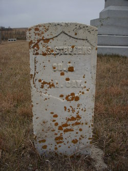
Charles Stephens
| Birth | : | 1822 England |
| Death | : | 6 Sep 1863 Dickey County, North Dakota, USA |
| Burial | : | Whitestone Hill State Historic Site, Merricourt, Dickey County, USA |
| Coordinate | : | 46.1689090, -98.8568200 |
| Description | : | Stephens, Charles. Age 40. Residence Earlville, nativity England. Enlisted Oct. 20, 1862. Sixth Iowa Cavalry. Mustered Dec. 6, 1862. Wounded fatally Sept. 3, 1863, White Stone Hill, Dak. Died of wounds Sept. 6, 1863, White Stone Hill, Dak. |
frequently asked questions (FAQ):
-
Where is Charles Stephens's memorial?
Charles Stephens's memorial is located at: Whitestone Hill State Historic Site, Merricourt, Dickey County, USA.
-
When did Charles Stephens death?
Charles Stephens death on 6 Sep 1863 in Dickey County, North Dakota, USA
-
Where are the coordinates of the Charles Stephens's memorial?
Latitude: 46.1689090
Longitude: -98.8568200
Family Members:
Spouse
Children
Flowers:
Nearby Cemetories:
1. Whitestone Hill State Historic Site
Merricourt, Dickey County, USA
Coordinate: 46.1689090, -98.8568200
2. Hoffnungsfeld Cemetery
Dickey County, USA
Coordinate: 46.1674995, -98.9002991
3. Spring Valley Cemetery
Merricourt, Dickey County, USA
Coordinate: 46.1062812, -98.9007168
4. Haffner Family Farm Cemetery
Merricourt, Dickey County, USA
Coordinate: 46.2055650, -98.7628900
5. Merricourt Cemetery
Merricourt, Dickey County, USA
Coordinate: 46.1999140, -98.7555030
6. Seventh-Day Adventist Cemetery
Dickey County, USA
Coordinate: 46.1422550, -98.9704330
7. Roloff Cemetery
Dickey County, USA
Coordinate: 46.2296982, -98.9439011
8. Zion United Methodist Cemetery
Dickey County, USA
Coordinate: 46.2731018, -98.9421997
9. Saint Pauls Lutheran Cemetery
Dickey County, USA
Coordinate: 46.2803001, -98.9210968
10. New Beresena Cemetery
LaMoure County, USA
Coordinate: 46.2977982, -98.8602982
11. Wirch Cemetery
Dickey County, USA
Coordinate: 46.0558014, -98.9533005
12. Peace Cemetery
Dickey County, USA
Coordinate: 46.2280998, -98.6821976
13. Unnamed Pioneer Cemetery
McIntosh County, USA
Coordinate: 46.0947200, -99.0252100
14. Gnadenfeld Congregational Cemetery
McIntosh County, USA
Coordinate: 46.2282982, -99.0441971
15. Saint Pauls Cemetery
Monango, Dickey County, USA
Coordinate: 46.1693993, -98.6508026
16. Pomona Valley Lutheran Cemetery
Kulm, LaMoure County, USA
Coordinate: 46.3064003, -98.9443970
17. Hillside Cemetery
Kulm, LaMoure County, USA
Coordinate: 46.3116600, -98.9744100
18. Kulm Congregational Cemetery
Kulm, LaMoure County, USA
Coordinate: 46.3114014, -98.9756012
19. Assembly of God Cemetery
Kulm, LaMoure County, USA
Coordinate: 46.3117190, -98.9766830
20. Monango City Cemetery
Monango, Dickey County, USA
Coordinate: 46.1764430, -98.6075310
21. Zion Lutheran Cemetery #2
Ashley, McIntosh County, USA
Coordinate: 46.0994600, -99.0879300
22. Salem Congregational Cemetery
McIntosh County, USA
Coordinate: 46.0269012, -99.0046997
23. Christ Lutheran Cemetery
Ellendale, Dickey County, USA
Coordinate: 46.0539090, -98.6497540
24. Saint Pauls Evangelical Lutheran Cemetery
Ashley, McIntosh County, USA
Coordinate: 46.0119300, -99.0151220


