

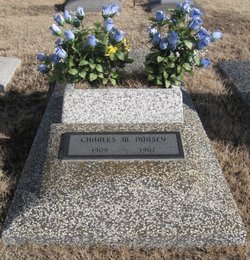
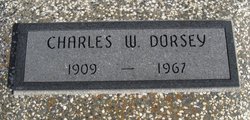
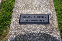
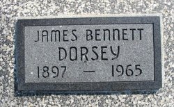
Charles Wesley “Charlie” Dorsey
| Birth | : | 27 Dec 1909 Huntsville, Madison County, Arkansas, USA |
| Death | : | 27 Jul 1967 Mulvane, Sumner County, Kansas, USA |
| Burial | : | Grant Evergreen Cemetery, Nemaha County, USA |
| Coordinate | : | 40.5065430, -96.0472250 |
| Description | : | Winfield Daily Courier, Winfield, Cowley County, KS - Friday, July 28, 1967 Charles W. Dorsey Grenola - Funeral services for Charles Wesley Dorsey, 57, Route 1, Grenola, who died Wednesday, will be Saturday at 2 p.m. at the Grenola Christian Church. Dorsey suffered a heart attack while driving on Highway K15 south of Mulvane. It was believed earlier that he had gone to sleep while driving, but an autopsy reported a heart attack was the cause of death. The pickup truck he was driving hit a bridge abuttment crossing a creek and skidded across the highway and struck... Read More |
frequently asked questions (FAQ):
-
Where is Charles Wesley “Charlie” Dorsey's memorial?
Charles Wesley “Charlie” Dorsey's memorial is located at: Grant Evergreen Cemetery, Nemaha County, USA.
-
When did Charles Wesley “Charlie” Dorsey death?
Charles Wesley “Charlie” Dorsey death on 27 Jul 1967 in Mulvane, Sumner County, Kansas, USA
-
Where are the coordinates of the Charles Wesley “Charlie” Dorsey's memorial?
Latitude: 40.5065430
Longitude: -96.0472250
Family Members:
Parent

Spouse
Siblings

Children
Flowers:


Nearby Cemetories:
1. Grant Evergreen Cemetery
Nemaha County, USA
Coordinate: 40.5065430, -96.0472250
2. Fairview Cemetery
Talmage, Otoe County, USA
Coordinate: 40.5525017, -96.0102997
3. Saint Pauls Cemetery
Talmage, Otoe County, USA
Coordinate: 40.5448810, -95.9919480
4. Livingston Cemetery
Cook, Johnson County, USA
Coordinate: 40.5080986, -96.1235962
5. Mount Hope Church Cemetery
Cook, Johnson County, USA
Coordinate: 40.4775000, -96.1233000
6. Lafayette Cemetery
Brock, Nemaha County, USA
Coordinate: 40.5127983, -95.9543991
7. Schacht Cemetery
Otoe County, USA
Coordinate: 40.5447006, -96.1271973
8. Saint Johns Cemetery
Talmage, Otoe County, USA
Coordinate: 40.5820847, -96.0474625
9. Zion Lutheran Church Cemetery
Johnson, Nemaha County, USA
Coordinate: 40.4287000, -96.0099000
10. Saint Pauls Cemetery
Otoe County, USA
Coordinate: 40.5372330, -96.1524720
11. Johnson Cemetery
Johnson, Nemaha County, USA
Coordinate: 40.4142000, -96.0052300
12. Coryell Park Mausoleum
Johnson, Nemaha County, USA
Coordinate: 40.4371150, -95.9548690
13. Biggs Cemetery
Lorton, Otoe County, USA
Coordinate: 40.6025009, -96.0105972
14. Clifton Cemetery
Johnson, Nemaha County, USA
Coordinate: 40.4333000, -95.9563980
15. Cook Cemetery
Cook, Johnson County, USA
Coordinate: 40.5168991, -96.1797028
16. Grace Lutheran Church Cemetery
Cook, Johnson County, USA
Coordinate: 40.5178000, -96.1799500
17. Saint Matthews Lutheran Cemetery
Johnson, Nemaha County, USA
Coordinate: 40.4073060, -96.0086500
18. Saint Joseph Catholic Cemetery
Paul, Otoe County, USA
Coordinate: 40.5806530, -95.9339190
19. Spring Creek Cemetery
Johnson County, USA
Coordinate: 40.3992004, -96.1222000
20. Delaware Lutheran Cemetery
Otoe County, USA
Coordinate: 40.6244087, -96.0870438
21. Glenrock Cemetery
Glenrock, Nemaha County, USA
Coordinate: 40.4644012, -95.8764038
22. Linden Cemetery
Nemaha County, USA
Coordinate: 40.4216995, -95.9032974
23. Saint Frederick Cemetery
Johnson, Nemaha County, USA
Coordinate: 40.3671989, -96.0475006
24. Bloomingdale Cemetery
Otoe County, USA
Coordinate: 40.5685997, -95.8783035