
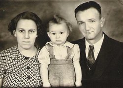
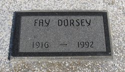
Faye Hawkins Dorsey
| Birth | : | 30 Nov 1916 Busby, Elk County, Kansas, USA |
| Death | : | 7 Feb 1992 Winfield, Cowley County, Kansas, USA |
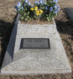
| Burial | : | Grant Evergreen Cemetery, Nemaha County, USA |
| Coordinate | : | 40.5065430, -96.0472250 |
| Description | : | Winfield Daily Courier, Winfield, Cowley County, KS - Monday, February 10, 1992 (page 10) Fay Dorsey Moline - Fay Dorsey, 75, of Moline, died Feb. 7, 1992, at William Newton Memorial Hospital. Born Nov. 30, 1916, in Busby, Kan., she was the daughter of George and Stacy (Spann) Hawkins. On April 8, 1937, she married Charles Wesley Dorsey in Howard, and he preceded her in death in 1967. Dorsey was a certified nurse's aide at Elk Manor Nursing Home in Moline before her retirement. She was a member of Royal Neighbors and the Moline Christian Church. Survivors... Read More |
frequently asked questions (FAQ):
-
Where is Faye Hawkins Dorsey's memorial?
Faye Hawkins Dorsey's memorial is located at: Grant Evergreen Cemetery, Nemaha County, USA.
-
When did Faye Hawkins Dorsey death?
Faye Hawkins Dorsey death on 7 Feb 1992 in Winfield, Cowley County, Kansas, USA
-
Where are the coordinates of the Faye Hawkins Dorsey's memorial?
Latitude: 40.5065430
Longitude: -96.0472250
Family Members:
Parent

Spouse

Siblings
Children
Flowers:


Nearby Cemetories:
1. Grant Evergreen Cemetery
Nemaha County, USA
Coordinate: 40.5065430, -96.0472250
2. Fairview Cemetery
Talmage, Otoe County, USA
Coordinate: 40.5525017, -96.0102997
3. Saint Pauls Cemetery
Talmage, Otoe County, USA
Coordinate: 40.5448810, -95.9919480
4. Livingston Cemetery
Cook, Johnson County, USA
Coordinate: 40.5080986, -96.1235962
5. Mount Hope Church Cemetery
Cook, Johnson County, USA
Coordinate: 40.4775000, -96.1233000
6. Lafayette Cemetery
Brock, Nemaha County, USA
Coordinate: 40.5127983, -95.9543991
7. Schacht Cemetery
Otoe County, USA
Coordinate: 40.5447006, -96.1271973
8. Saint Johns Cemetery
Talmage, Otoe County, USA
Coordinate: 40.5820847, -96.0474625
9. Zion Lutheran Church Cemetery
Johnson, Nemaha County, USA
Coordinate: 40.4287000, -96.0099000
10. Saint Pauls Cemetery
Otoe County, USA
Coordinate: 40.5372330, -96.1524720
11. Johnson Cemetery
Johnson, Nemaha County, USA
Coordinate: 40.4142000, -96.0052300
12. Coryell Park Mausoleum
Johnson, Nemaha County, USA
Coordinate: 40.4371150, -95.9548690
13. Biggs Cemetery
Lorton, Otoe County, USA
Coordinate: 40.6025009, -96.0105972
14. Clifton Cemetery
Johnson, Nemaha County, USA
Coordinate: 40.4333000, -95.9563980
15. Cook Cemetery
Cook, Johnson County, USA
Coordinate: 40.5168991, -96.1797028
16. Grace Lutheran Church Cemetery
Cook, Johnson County, USA
Coordinate: 40.5178000, -96.1799500
17. Saint Matthews Lutheran Cemetery
Johnson, Nemaha County, USA
Coordinate: 40.4073060, -96.0086500
18. Saint Joseph Catholic Cemetery
Paul, Otoe County, USA
Coordinate: 40.5806530, -95.9339190
19. Spring Creek Cemetery
Johnson County, USA
Coordinate: 40.3992004, -96.1222000
20. Delaware Lutheran Cemetery
Otoe County, USA
Coordinate: 40.6244087, -96.0870438
21. Glenrock Cemetery
Glenrock, Nemaha County, USA
Coordinate: 40.4644012, -95.8764038
22. Linden Cemetery
Nemaha County, USA
Coordinate: 40.4216995, -95.9032974
23. Saint Frederick Cemetery
Johnson, Nemaha County, USA
Coordinate: 40.3671989, -96.0475006
24. Bloomingdale Cemetery
Otoe County, USA
Coordinate: 40.5685997, -95.8783035