
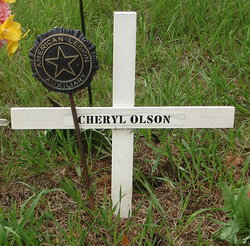
Cheryl Lynn Green Olson
| Birth | : | 26 Feb 1949 Yankton, Yankton County, South Dakota, USA |
| Death | : | 27 Jan 2012 North Bend, Dodge County, Nebraska, USA |
| Burial | : | L'Eau Qui Court Cemetery, Niobrara, Knox County, USA |
| Coordinate | : | 42.7458000, -98.0231018 |
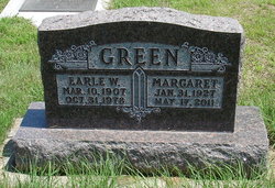
| Description | : | Cheryl Lynn Olson's life began on February 26, 1949, when she was born with her twin brother, Ronald, in Yankton, South Dakota, to Earle and Margaret (Fritz) Green. Cheryl was later joined by a little sister, Vicki. Cheryl was raised in Niobrara, Nebraska, where she attended elementary and high school, graduating in 1967. Following graduation, Cheryl attended Norfolk Junior College for two years. On August 24, 1979, at the Niobrara Presbyterian Church, Cheryl was married to Dallas Olson, whom she loved until her last breath. Together, Cheryl and Dallas raised three children: Alicia, Chad, and Tonya. Cheryl's love for the restaurant... Read More |
frequently asked questions (FAQ):
-
Where is Cheryl Lynn Green Olson's memorial?
Cheryl Lynn Green Olson's memorial is located at: L'Eau Qui Court Cemetery, Niobrara, Knox County, USA.
-
When did Cheryl Lynn Green Olson death?
Cheryl Lynn Green Olson death on 27 Jan 2012 in North Bend, Dodge County, Nebraska, USA
-
Where are the coordinates of the Cheryl Lynn Green Olson's memorial?
Latitude: 42.7458000
Longitude: -98.0231018
Family Members:
Parent

Spouse
Siblings

Flowers:


Nearby Cemetories:
1. L'Eau Qui Court Cemetery
Niobrara, Knox County, USA
Coordinate: 42.7458000, -98.0231018
2. Mormon Monument
Ponca, Knox County, USA
Coordinate: 42.7443000, -98.0632500
3. Ponka Tribal Cemetery
Knox County, USA
Coordinate: 42.7122700, -98.0830000
4. Bazile Creek Cemetery
Bazile Mills, Knox County, USA
Coordinate: 42.7377500, -97.9311500
5. Emanuel Cemetery
Springfield, Bon Homme County, USA
Coordinate: 42.8400002, -97.9903030
6. Kurka Family Cemetery
Dukesville, Knox County, USA
Coordinate: 42.6918000, -98.1374000
7. Ponca Evangelical Lutheran Cemetery
Niobrara, Knox County, USA
Coordinate: 42.7428000, -98.1621000
8. Riverview Cemetery
Knox County, USA
Coordinate: 42.7322006, -98.1619034
9. Pioneer Cemetery
Springfield, Bon Homme County, USA
Coordinate: 42.8513985, -98.0500031
10. Hillcrest Cemetery
Verdigre, Knox County, USA
Coordinate: 42.6356010, -98.0378036
11. Pleasant Hill Cemetery
Verdigre, Knox County, USA
Coordinate: 42.6837500, -98.1619500
12. Bethlehem Lutheran Cemetery
Springfield, Bon Homme County, USA
Coordinate: 42.8727989, -98.0494003
13. Saint Wenceslaus Cemetery
Verdigre, Knox County, USA
Coordinate: 42.6039009, -98.0428009
14. Riverside Cemetery
Verdigre, Knox County, USA
Coordinate: 42.6011009, -98.0286026
15. Ponca Valley Cemetery
Verdel, Knox County, USA
Coordinate: 42.8135000, -98.1990000
16. Springfield Cemetery
Springfield, Bon Homme County, USA
Coordinate: 42.8732986, -97.9132996
17. Saint Vincents Cemetery
Springfield, Bon Homme County, USA
Coordinate: 42.8744011, -97.9132996
18. Congregational Cemetery
Santee, Knox County, USA
Coordinate: 42.8330000, -97.8523000
19. Friedensberg Mennonite Cemetery
Avon, Bon Homme County, USA
Coordinate: 42.8958015, -98.0667038
20. Bohemian National Cemetery
Knox County, USA
Coordinate: 42.6178017, -98.1483002
21. Santee Mission Cemetery
Knox County, USA
Coordinate: 42.8408000, -97.8378200
22. Howe Creek Cemetery
Lindy, Knox County, USA
Coordinate: 42.6810000, -97.8127000
23. National Cemetery
Pishelville, Knox County, USA
Coordinate: 42.7190000, -98.2500000
24. Santee Catholic Cemetery
Santee, Knox County, USA
Coordinate: 42.8373000, -97.8287400