
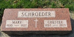
Chester Otto “Chet” Schroeder
| Birth | : | 25 Nov 1893 Des Moines, Polk County, Iowa, USA |
| Death | : | 18 Jan 1929 Detroit, Wayne County, Michigan, USA |
| Burial | : | Mount Olivet Cemetery, Carroll, Carroll County, USA |
| Coordinate | : | 42.0536340, -94.8595510 |
| Description | : | Chester was the son of Isaac Graff Schroeder and Barbara Schroeder. He married Mary Fritz on Feb 14, 1914 at Carroll, Iowa. They were the parents of Franklin Henry, Rose, and Robert. Jan 23, 1929 - Carroll Times - Mr. and Mrs. R.G. Billmire returned from Detroit, Mich., Tuesday night, where they had been called by the death of C.O. Schroeder, a brother-in-law of Mrs. Billmire. Mr. Schroeder died in a Detroit hospital Friday, January 18, after a short illness with flu and complications. He had not been well for two years. He entered the hospital January 11, 1929. A... Read More |
frequently asked questions (FAQ):
-
Where is Chester Otto “Chet” Schroeder's memorial?
Chester Otto “Chet” Schroeder's memorial is located at: Mount Olivet Cemetery, Carroll, Carroll County, USA.
-
When did Chester Otto “Chet” Schroeder death?
Chester Otto “Chet” Schroeder death on 18 Jan 1929 in Detroit, Wayne County, Michigan, USA
-
Where are the coordinates of the Chester Otto “Chet” Schroeder's memorial?
Latitude: 42.0536340
Longitude: -94.8595510
Family Members:
Spouse

Flowers:


Nearby Cemetories:
1. Mount Olivet Cemetery
Carroll, Carroll County, USA
Coordinate: 42.0536340, -94.8595510
2. Carroll City Cemetery
Carroll, Carroll County, USA
Coordinate: 42.0560963, -94.8599856
3. Holy Angels Cemetery
Carroll County, USA
Coordinate: 42.0014000, -94.9141998
4. Saint Francis Cemetery
Maple River, Carroll County, USA
Coordinate: 42.0969009, -94.9372025
5. Saint Marys Catholic Cemetery
Willey, Carroll County, USA
Coordinate: 41.9783363, -94.8212204
6. Holy Family Cemetery
Lidderdale, Carroll County, USA
Coordinate: 42.1178017, -94.7839966
7. West Lawn Cemetery
Glidden, Carroll County, USA
Coordinate: 42.0649986, -94.7406006
8. Immanuel Cemetery
Lidderdale, Carroll County, USA
Coordinate: 42.1389008, -94.8022003
9. Saint Augustine Cemetery
Halbur, Carroll County, USA
Coordinate: 42.0066986, -94.9744034
10. Our Lady Of Mount Carmel Cemetery
Mount Carmel, Carroll County, USA
Coordinate: 42.1547012, -94.9088974
11. Arcadia Cemetery
Arcadia Township, Carroll County, USA
Coordinate: 42.1000680, -95.0130550
12. East Liberty Cemetery
Lidderdale, Carroll County, USA
Coordinate: 42.1591988, -94.7636032
13. McCurdy Cemetery
Carroll County, USA
Coordinate: 41.9403000, -94.7649994
14. Saint Johns Catholic Cemetery
Arcadia, Carroll County, USA
Coordinate: 42.0855406, -95.0341577
15. Dickson Cemetery
Glidden Township, Carroll County, USA
Coordinate: 42.1074982, -94.6939011
16. Saint Bernards Cemetery
Breda, Carroll County, USA
Coordinate: 42.1786003, -94.9732971
17. Elba Cemetery
Templeton, Carroll County, USA
Coordinate: 41.9068985, -94.9131012
18. Sacred Heart Cemetery
Templeton, Carroll County, USA
Coordinate: 41.9138746, -94.9460994
19. Dedham Cemetery
Dedham, Carroll County, USA
Coordinate: 41.8993988, -94.8225021
20. Saint Josephs Cemetery
Dedham, Carroll County, USA
Coordinate: 41.8993988, -94.8210983
21. North Coon Cemetery
Carroll County, USA
Coordinate: 42.1260986, -94.6716995
22. Old Carrollton Cemetery
Carrollton, Carroll County, USA
Coordinate: 41.9233017, -94.7403030
23. Lanesboro Cemetery
Lanesboro, Carroll County, USA
Coordinate: 42.1810989, -94.7230988
24. Luckow Cemetery
Auburn, Sac County, USA
Coordinate: 42.2168999, -94.9266968