
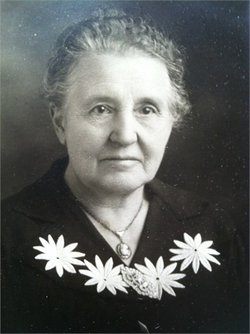
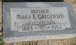
| Birth | : | 4 Feb 1848 |
| Death | : | 23 Feb 1923 |
| Burial | : | All Saints Churchyard, Salhouse, Broadland District, England |
| Coordinate | : | 52.6833600, 1.4063280 |
frequently asked questions (FAQ):
-
Where is Christina Kliver Mortensen's memorial?
Christina Kliver Mortensen's memorial is located at: All Saints Churchyard, Salhouse, Broadland District, England.
-
When did Christina Kliver Mortensen death?
Christina Kliver Mortensen death on 23 Feb 1923 in
-
Where are the coordinates of the Christina Kliver Mortensen's memorial?
Latitude: 52.6833600
Longitude: 1.4063280
Family Members:
Spouse

Children
Flowers:


Nearby Cemetories:
1. All Saints Churchyard
Salhouse, Broadland District, England
Coordinate: 52.6833600, 1.4063280
2. Salhouse Baptist Church
Salhouse, Broadland District, England
Coordinate: 52.6807500, 1.4223800
3. St. Mary the Virgin Churchyard
Wroxham, Broadland District, England
Coordinate: 52.7067470, 1.3984620
4. Wroxham Parish Council Cemetery
Wroxham, Broadland District, England
Coordinate: 52.7079631, 1.3994432
5. St. Fabian & St. Sebastian Churchyard
Woodbastwick, Broadland District, England
Coordinate: 52.6841900, 1.4492890
6. St John's Churchyard
Hoveton, North Norfolk District, England
Coordinate: 52.7120040, 1.4174270
7. All Saints Churchyard
Rackheath, Broadland District, England
Coordinate: 52.6846160, 1.3573490
8. St. Peter's Churchyard
Belaugh, Broadland District, England
Coordinate: 52.7153080, 1.3867600
9. St Gervase and St Protase Churchyard
Little Plumstead, Broadland District, England
Coordinate: 52.6468000, 1.4093000
10. All Saints Churchyard
Panxworth, Broadland District, England
Coordinate: 52.6688790, 1.4703430
11. St. Peter Crostwick Church Cemetery
Crostwick, Broadland District, England
Coordinate: 52.6934480, 1.3395750
12. St. Peter's Churchyard
Hoveton, North Norfolk District, England
Coordinate: 52.7239790, 1.4256250
13. St. Mary the Virgin Churchyard
Great Plumstead, North Norfolk District, England
Coordinate: 52.6385560, 1.4007180
14. St. Mary the Virgin Churchyard
Great Plumstead, Broadland District, England
Coordinate: 52.6384790, 1.4008340
15. St. Helen's Churchyard
Ranworth, Broadland District, England
Coordinate: 52.6792260, 1.4836790
16. St. Benedict's Church Cemetery
Horning, North Norfolk District, England
Coordinate: 52.6955690, 1.4836570
17. St. John the Baptist Churchyard
Coltishall, Broadland District, England
Coordinate: 52.7278530, 1.3626450
18. Sprowston Cemetery
Sprowston, Broadland District, England
Coordinate: 52.6644440, 1.3249400
19. St. Mary and St. Margaret Churchyard
Sprowston, Broadland District, England
Coordinate: 52.6635430, 1.3248800
20. Neatishead Baptist Churchyard
Neatishead, North Norfolk District, England
Coordinate: 52.7240100, 1.4633560
21. All Saints Churchyard
Hemblington, Broadland District, England
Coordinate: 52.6505100, 1.4769600
22. Cucumber Lane Cemetery
Brundall, Broadland District, England
Coordinate: 52.6304330, 1.4259830
23. St. Peter Churchyard
Neatishead, North Norfolk District, England
Coordinate: 52.7244260, 1.4703220
24. St. Swithin's Churchyard
Ashmanhaugh, North Norfolk District, England
Coordinate: 52.7384470, 1.4271260