
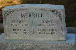
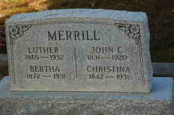
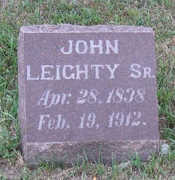
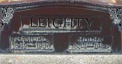
Christina Leighty Merrill
| Birth | : | Mar 1842 Holmes County, Ohio, USA |
| Death | : | 29 Jan 1931 Alameda County, California, USA |
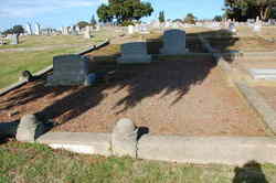
| Burial | : | Gardnerville Cemetery, Gardnerville, Douglas County, USA |
| Coordinate | : | 38.9463997, -119.7592010 |
| Plot | : | Plot 10, Section 9 |
frequently asked questions (FAQ):
-
Where is Christina Leighty Merrill's memorial?
Christina Leighty Merrill's memorial is located at: Gardnerville Cemetery, Gardnerville, Douglas County, USA.
-
When did Christina Leighty Merrill death?
Christina Leighty Merrill death on 29 Jan 1931 in Alameda County, California, USA
-
Where are the coordinates of the Christina Leighty Merrill's memorial?
Latitude: 38.9463997
Longitude: -119.7592010
Family Members:
Parent
Spouse
Siblings

Flowers:


Nearby Cemetories:
1. Gardnerville Cemetery
Gardnerville, Douglas County, USA
Coordinate: 38.9463997, -119.7592010
2. Eastside Memorial Park
Minden, Douglas County, USA
Coordinate: 38.9623985, -119.7320023
3. Captain George Donner Cemetery
Kingsbury, Douglas County, USA
Coordinate: 38.9542007, -119.8394012
4. Mottsville Cemetery
Douglas County, USA
Coordinate: 38.9319000, -119.8383026
5. Clara Holbrook Frank Family Cemetery
Gardnerville, Douglas County, USA
Coordinate: 38.8904900, -119.6936600
6. Washoe Cemetery
Gardnerville, Douglas County, USA
Coordinate: 38.8699900, -119.7455400
7. Knott Family Graveyard
Genoa, Douglas County, USA
Coordinate: 39.0069900, -119.8452400
8. Genoa Cemetery
Genoa, Douglas County, USA
Coordinate: 39.0116997, -119.8431015
9. Happy Hunting Grounds Cemetery
Gardnerville, Douglas County, USA
Coordinate: 38.8657000, -119.6524000
10. Fredericksburg Cemetery
Frederickburg, Alpine County, USA
Coordinate: 38.8275986, -119.7866974
11. Jacks Valley Cemetery
Douglas County, USA
Coordinate: 39.0840751, -119.8468480
12. Happy Homestead Cemetery
South Lake Tahoe, El Dorado County, USA
Coordinate: 38.9371986, -119.9681015
13. Johnson-Springmeyer Cemetery
South Lake Tahoe, El Dorado County, USA
Coordinate: 38.9376580, -119.9681600
14. Ormsby Poor Farm Cemetery
Carson City, Carson City, USA
Coordinate: 39.1172066, -119.7700043
15. Stewart Cemetery
Carson City, Carson City, USA
Coordinate: 39.1175800, -119.7701000
16. Old Stewart Indian Cemetery
Stewart, Carson City, USA
Coordinate: 39.1178900, -119.7546700
17. Al Tahoe Cemetery
South Lake Tahoe, El Dorado County, USA
Coordinate: 38.9411011, -119.9875565
18. Old Woodfords Cemetery
Alpine County, USA
Coordinate: 38.7762710, -119.8255320
19. Woodfords Washoe Indian Cemetery
Woodfords, Alpine County, USA
Coordinate: 38.7688570, -119.8190720
20. Saint Johns in the Wilderness Episcopal Columbariu
Glenbrook, Douglas County, USA
Coordinate: 39.0722520, -119.9422930
21. Glenbrook Cemetery
Glenbrook, Douglas County, USA
Coordinate: 39.0891100, -119.9352500
22. Dixon Family Cemetery
Carson City, USA
Coordinate: 39.1483269, -119.7432404
23. Nevada State Prison Burial Ground
Carson City, Carson City, USA
Coordinate: 39.1581900, -119.7378200
24. Carson Pioneer Cemetery
Carson City, Carson City, USA
Coordinate: 39.1612396, -119.7792969