
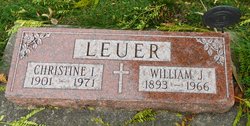
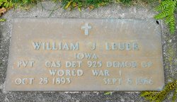
Christine I Grobmeier Leuer
| Birth | : | 15 Jul 1901 Harlan, Shelby County, Iowa, USA |
| Death | : | 5 Feb 1971 Carroll, Carroll County, Iowa, USA |
| Burial | : | Mount Olivet Cemetery, Carroll, Carroll County, USA |
| Coordinate | : | 42.0536340, -94.8595510 |
| Description | : | Christine was the daughter of Joseph and Christine Grobmeier. She married William Leuer in Oct 1944 in Carroll, Iowa. Feb 9, 1971 - Carroll Daily Times - Requiem mass for Mrs. Christine Leuer, 69, of Carroll, was celebrated at 1 p.m. Monday in St. Lawrence Church. She died Feb. 5 at the Carroll Health Center following a long illness. The Rt. Rev. Msgr. Henry B. Karhoff officiated. Pallbearers were Elmer Friedman, Dr. Donald J. Casey, Lambert Thelen, James Kratoska, William Lux, and Mike Wittrock. Burial was in Mt. Olivet Cemetery. Arrangements were in charge of the Sharp Funeral Home. Mrs. Leuer... Read More |
frequently asked questions (FAQ):
-
Where is Christine I Grobmeier Leuer's memorial?
Christine I Grobmeier Leuer's memorial is located at: Mount Olivet Cemetery, Carroll, Carroll County, USA.
-
When did Christine I Grobmeier Leuer death?
Christine I Grobmeier Leuer death on 5 Feb 1971 in Carroll, Carroll County, Iowa, USA
-
Where are the coordinates of the Christine I Grobmeier Leuer's memorial?
Latitude: 42.0536340
Longitude: -94.8595510
Family Members:

Flowers:


Nearby Cemetories:
1. Mount Olivet Cemetery
Carroll, Carroll County, USA
Coordinate: 42.0536340, -94.8595510
2. Carroll City Cemetery
Carroll, Carroll County, USA
Coordinate: 42.0560963, -94.8599856
3. Holy Angels Cemetery
Carroll County, USA
Coordinate: 42.0014000, -94.9141998
4. Saint Francis Cemetery
Maple River, Carroll County, USA
Coordinate: 42.0969009, -94.9372025
5. Saint Marys Catholic Cemetery
Willey, Carroll County, USA
Coordinate: 41.9783363, -94.8212204
6. Holy Family Cemetery
Lidderdale, Carroll County, USA
Coordinate: 42.1178017, -94.7839966
7. West Lawn Cemetery
Glidden, Carroll County, USA
Coordinate: 42.0649986, -94.7406006
8. Immanuel Cemetery
Lidderdale, Carroll County, USA
Coordinate: 42.1389008, -94.8022003
9. Saint Augustine Cemetery
Halbur, Carroll County, USA
Coordinate: 42.0066986, -94.9744034
10. Our Lady Of Mount Carmel Cemetery
Mount Carmel, Carroll County, USA
Coordinate: 42.1547012, -94.9088974
11. Arcadia Cemetery
Arcadia Township, Carroll County, USA
Coordinate: 42.1000680, -95.0130550
12. East Liberty Cemetery
Lidderdale, Carroll County, USA
Coordinate: 42.1591988, -94.7636032
13. McCurdy Cemetery
Carroll County, USA
Coordinate: 41.9403000, -94.7649994
14. Saint Johns Catholic Cemetery
Arcadia, Carroll County, USA
Coordinate: 42.0855406, -95.0341577
15. Dickson Cemetery
Glidden Township, Carroll County, USA
Coordinate: 42.1074982, -94.6939011
16. Saint Bernards Cemetery
Breda, Carroll County, USA
Coordinate: 42.1786003, -94.9732971
17. Elba Cemetery
Templeton, Carroll County, USA
Coordinate: 41.9068985, -94.9131012
18. Sacred Heart Cemetery
Templeton, Carroll County, USA
Coordinate: 41.9138746, -94.9460994
19. Dedham Cemetery
Dedham, Carroll County, USA
Coordinate: 41.8993988, -94.8225021
20. Saint Josephs Cemetery
Dedham, Carroll County, USA
Coordinate: 41.8993988, -94.8210983
21. North Coon Cemetery
Carroll County, USA
Coordinate: 42.1260986, -94.6716995
22. Old Carrollton Cemetery
Carrollton, Carroll County, USA
Coordinate: 41.9233017, -94.7403030
23. Lanesboro Cemetery
Lanesboro, Carroll County, USA
Coordinate: 42.1810989, -94.7230988
24. Luckow Cemetery
Auburn, Sac County, USA
Coordinate: 42.2168999, -94.9266968