
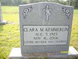
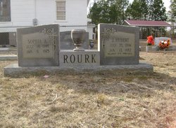
Clara Mae Rourk Kemmerlin
| Birth | : | 5 Aug 1923 |
| Death | : | 16 Nov 2006 |
| Burial | : | Trinity Lutheran Church Cemetery, Elloree, Orangeburg County, USA |
| Coordinate | : | 33.5603720, -80.5659850 |
| Description | : | Ms. Clara Rourk Kemmerlin -- Santee Saturday, November 18, 2006 Funeral services for Ms. Clara Rourk Kemmerlin, 83, of 1740 Bonner Ave., Santee, will be held at 2 p.m. Saturday, Nov. 18, 2006 at Fogle-Hungerpiller Funeral Home, with the Rev. John Hucks officiating. Burial will be in Trinity Lutheran Church Cemetery. The casket will be open for viewing one hour prior to the service. Pallbearers will be James Simpkins (grandson), Jesse Griffis (great-grandson), Sonny Rourk (grandson), Ray Zeigler (nephew), Walter ?Bubba? Zeigler (nephew) and Christopher Peagler (friend of the family). Ms. Kemmerlin left this world Thursday, Nov. 16, 2006 to be with God and her... Read More |
frequently asked questions (FAQ):
-
Where is Clara Mae Rourk Kemmerlin's memorial?
Clara Mae Rourk Kemmerlin's memorial is located at: Trinity Lutheran Church Cemetery, Elloree, Orangeburg County, USA.
-
When did Clara Mae Rourk Kemmerlin death?
Clara Mae Rourk Kemmerlin death on 16 Nov 2006 in
-
Where are the coordinates of the Clara Mae Rourk Kemmerlin's memorial?
Latitude: 33.5603720
Longitude: -80.5659850
Family Members:
Parent

Spouse

Siblings
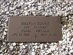
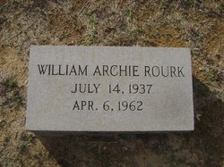
Children
Flowers:


Nearby Cemetories:
1. Union AME Church Cemetery
Calhoun County, USA
Coordinate: 33.5840910, -80.5575110
2. Bookhart Cemetery
Elloree, Orangeburg County, USA
Coordinate: 33.5485992, -80.5924988
3. Magrill Family Cemetery
Calhoun County, USA
Coordinate: 33.5601790, -80.5354270
4. Santee First Baptist Cemetery
Elloree, Orangeburg County, USA
Coordinate: 33.5553700, -80.6018080
5. Elloree Hillcrest Cemetery
Elloree, Orangeburg County, USA
Coordinate: 33.5608720, -80.6099720
6. Browning Branch Cemetery
Elloree, Orangeburg County, USA
Coordinate: 33.5231820, -80.5632140
7. New Faith Community Church Cemetery
Elloree, Orangeburg County, USA
Coordinate: 33.5229150, -80.5477570
8. Mount Zion AME Church Cemetery
Creston, Calhoun County, USA
Coordinate: 33.5689940, -80.6151050
9. Jerusalem Cemetery
Elloree, Orangeburg County, USA
Coordinate: 33.5102340, -80.5447570
10. Haynes Chapel AME Church Cemetery
Cameron, Calhoun County, USA
Coordinate: 33.6130110, -80.5751970
11. Mount Hebron Baptist Church Cemetery
Santee, Orangeburg County, USA
Coordinate: 33.5028570, -80.5381980
12. Parlerville A.M.E. Church Cemetery
Santee, Orangeburg County, USA
Coordinate: 33.5208030, -80.5039540
13. Bodrick Cemetery
Lone Star, Calhoun County, USA
Coordinate: 33.6245880, -80.5891440
14. Mount Pisgah Church Cemetery
Santee, Orangeburg County, USA
Coordinate: 33.5182200, -80.5027480
15. Hungerpiller Family Cemetery
Elloree, Orangeburg County, USA
Coordinate: 33.5049010, -80.6123380
16. Cedar Grove Baptist Church Cemetery
Lone Star, Calhoun County, USA
Coordinate: 33.6259320, -80.5947950
17. Hart Graveyard
Holly Hill, Orangeburg County, USA
Coordinate: 33.4918320, -80.5470820
18. Irick Cemetery
Lone Star, Calhoun County, USA
Coordinate: 33.6283580, -80.5924100
19. Smith-Dantzler Cemetery
Elloree, Orangeburg County, USA
Coordinate: 33.4941130, -80.6052520
20. Whitmore, Avinger, Norris, Felder Cemetery
Elloree, Orangeburg County, USA
Coordinate: 33.4870530, -80.5532600
21. Granger Baptist Church Cemetery
Elloree, Orangeburg County, USA
Coordinate: 33.4909840, -80.6030410
22. Gresham Cemetery
Orangeburg County, USA
Coordinate: 33.4906006, -80.6031036
23. Pine Grove Lutheran Church Cemetery
Lone Star, Calhoun County, USA
Coordinate: 33.6349610, -80.6016470
24. McGrew Cemetery
Elloree, Orangeburg County, USA
Coordinate: 33.4859880, -80.6027150