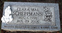
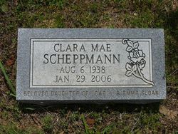
Clara Mae Sloan Scheppmann
| Birth | : | 6 Aug 1938 Arkansas, USA |
| Death | : | 29 Jan 2006 Russellville, Pope County, Arkansas, USA |
| Burial | : | St. Leonard Old Churchyard, Langho, Ribble Valley Borough, England |
| Coordinate | : | 53.8178590, -2.4552870 |
| Description | : | Parents: Lowell Mason and Emma Jewell McElroy Sloan Spouse: Larry Scheppmann∼Clara Mae Scheppmann, 66, of Russellville, died Sunday, Jan. 29, 2006, at Saint Mary's Regional Medical Center. She was born Aug. 6, 1938, to Lowell Mason and Emma Jewell McElroy Sloan. She was a homemaker, enjoyed fishing and was associated with the New Beginnings Church of God. She was preceded in death by her mother and her husband, Larry Scheppmann. Survivors include her father, Lowell M. Sloan of Russellville; two sisters, Bonnie Laseter of Russellville and Connie Willis of Cleveland, Tenn.; four nephews; and four nieces. |
frequently asked questions (FAQ):
-
Where is Clara Mae Sloan Scheppmann's memorial?
Clara Mae Sloan Scheppmann's memorial is located at: St. Leonard Old Churchyard, Langho, Ribble Valley Borough, England.
-
When did Clara Mae Sloan Scheppmann death?
Clara Mae Sloan Scheppmann death on 29 Jan 2006 in Russellville, Pope County, Arkansas, USA
-
Where are the coordinates of the Clara Mae Sloan Scheppmann's memorial?
Latitude: 53.8178590
Longitude: -2.4552870
Family Members:
Parent
Flowers:
Nearby Cemetories:
1. St. Leonard Old Churchyard
Langho, Ribble Valley Borough, England
Coordinate: 53.8178590, -2.4552870
2. Brockhall Hospital Cemetery
Brockhall Village, Ribble Valley Borough, England
Coordinate: 53.8186850, -2.4560220
3. St John the Evangelist Churchyard
Hurst Green, Ribble Valley Borough, England
Coordinate: 53.8358000, -2.4852530
4. St. Joseph Roman Catholic Churchyard
Hurst Green, Ribble Valley Borough, England
Coordinate: 53.8409900, -2.4820600
5. Stonyhurst College Burial Ground
Hurst Green, Ribble Valley Borough, England
Coordinate: 53.8403420, -2.4840310
6. Saint Mary and All Saints Churchyard
Whalley, Ribble Valley Borough, England
Coordinate: 53.8211890, -2.4078080
7. Calderstones Hospital Cemetery
Whalley, Ribble Valley Borough, England
Coordinate: 53.8338710, -2.4147160
8. Queen Mary's Military Hospital Cemetery
Whalley, Ribble Valley Borough, England
Coordinate: 53.8337490, -2.4127930
9. All Hallows Churchyard
Great Mitton, Ribble Valley Borough, England
Coordinate: 53.8461500, -2.4339000
10. St Peter Churchyard
Salesbury, Ribble Valley Borough, England
Coordinate: 53.7915000, -2.4859100
11. Whalley, Wiswell and Barrow Cemetery
Whalley, Ribble Valley Borough, England
Coordinate: 53.8308490, -2.4057280
12. St. Bartholomew's Churchyard
Great Harwood, Hyndburn Borough, England
Coordinate: 53.7900670, -2.4055460
13. The Church of St. Saviour The Holy House of Stydd
Ribchester, Ribble Valley Borough, England
Coordinate: 53.8188690, -2.5272770
14. Our Lady and Saint Hubert
Great Harwood, Hyndburn Borough, England
Coordinate: 53.7851070, -2.4009760
15. St Wilfrid Churchyard
Ribchester, Ribble Valley Borough, England
Coordinate: 53.8102780, -2.5332650
16. Great Harwood Cemetery
Great Harwood, Hyndburn Borough, England
Coordinate: 53.7796190, -2.4091680
17. Blackburn Cemetery
Blackburn, Blackburn with Darwen Unitary Authority, England
Coordinate: 53.7662430, -2.4726050
18. St. John's Churchyard
Read, Ribble Valley Borough, England
Coordinate: 53.8088800, -2.3585600
19. All Saints Churchyard
Clayton-le-Moors, Hyndburn Borough, England
Coordinate: 53.7738520, -2.3881690
20. St Mary's R.C. Church Cemetery
Osbaldeston, Ribble Valley Borough, England
Coordinate: 53.7816970, -2.5350240
21. Knowle Green Congregational Graveyard
Knowle Green, Ribble Valley Borough, England
Coordinate: 53.8380170, -2.5507210
22. Barnes Square Weslyan Methodist Churchyard
Clayton-le-Moors, Hyndburn Borough, England
Coordinate: 53.7744350, -2.3853800
23. Mellor Methodist Churchyard
Blackburn, Blackburn with Darwen Unitary Authority, England
Coordinate: 53.7742950, -2.5255060
24. St James Churchyard
Clitheroe, Ribble Valley Borough, England
Coordinate: 53.8659600, -2.3922700


