
| Birth | : | 18 Dec 1815 Lower Saxony (Niedersachsen), Germany |
| Death | : | 5 Aug 1854 St. Charles County, Missouri, USA |
| Burial | : | Sanford Cemetery, Sanford, Conejos County, USA |
| Coordinate | : | 37.2374992, -105.9103012 |
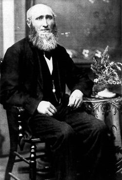
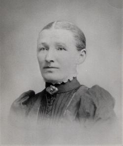
| Description | : | First wife of Johann Friedrich Benne. Along with several other Benne family members, Clara died in the summer of 1854. Her death was recorded by Immanuel Evangelical Lutheran Church and she is likely buried in the old section of the cemetery where few markers remain. |
frequently asked questions (FAQ):
-
Where is Clara Maria Langenheder Benne's memorial?
Clara Maria Langenheder Benne's memorial is located at: Sanford Cemetery, Sanford, Conejos County, USA.
-
When did Clara Maria Langenheder Benne death?
Clara Maria Langenheder Benne death on 5 Aug 1854 in St. Charles County, Missouri, USA
-
Where are the coordinates of the Clara Maria Langenheder Benne's memorial?
Latitude: 37.2374992
Longitude: -105.9103012
Family Members:
Spouse
Children

Flowers:


Nearby Cemetories:
1. Sanford Cemetery
Sanford, Conejos County, USA
Coordinate: 37.2374992, -105.9103012
2. La Jara Cemetery
La Jara, Conejos County, USA
Coordinate: 37.2977982, -105.9610977
3. Old Manassa Cemetery
Manassa, Conejos County, USA
Coordinate: 37.1575012, -105.9366989
4. Sowards Cemetery
Manassa, Conejos County, USA
Coordinate: 37.1577988, -105.9381027
5. Nance Family Cemetery
Manassa, Conejos County, USA
Coordinate: 37.1569020, -105.9380870
6. Flower Family Graves
Manassa, Conejos County, USA
Coordinate: 37.1519000, -105.8915000
7. Los Cerritos Cemetery
Los Cerritos, Conejos County, USA
Coordinate: 37.1494000, -105.9127000
8. New Manassa Cemetery
Manassa, Conejos County, USA
Coordinate: 37.1486015, -105.9203033
9. Gate to Heaven Cemetery
Los Sauces, Conejos County, USA
Coordinate: 37.2375000, -105.7560000
10. Los Lasauses Pentecostal Cemetery
Los Sauces, Conejos County, USA
Coordinate: 37.2362520, -105.7557920
11. Los Sauces Church Yard Cemetery
Los Sauces, Conejos County, USA
Coordinate: 37.2658620, -105.7464570
12. La Isla Cemetery
Manassa, Conejos County, USA
Coordinate: 37.0864860, -105.9555750
13. Saint Joseph Cemetery
Conejos County, USA
Coordinate: 37.2841988, -106.0980988
14. Saint Joseph Church Old Cemetery
Capulin, Conejos County, USA
Coordinate: 37.2814000, -106.1118000
15. Old Capulin Cemetery
Capulin, Conejos County, USA
Coordinate: 37.2980995, -106.1097031
16. Lobatos Cemetery
Conejos County, USA
Coordinate: 37.0630989, -105.9116974
17. Conejos Cemetery
Antonito, Conejos County, USA
Coordinate: 37.0842018, -106.0175018
18. Warshaver Cemetery
Antonito, Conejos County, USA
Coordinate: 37.0828018, -106.0152969
19. Antonito Cemetery
Antonito, Conejos County, USA
Coordinate: 37.0819016, -106.0156021
20. Becker Cemetery
Alamosa County, USA
Coordinate: 37.3669014, -105.7478027
21. Alamosa Municipal Cemetery
Alamosa, Alamosa County, USA
Coordinate: 37.4495000, -105.8591000
22. Alamosa Spanish Cemetery
Alamosa, Alamosa County, USA
Coordinate: 37.4592000, -105.8929000
23. Mogote Presbyterian Cemetery
Mogote, Conejos County, USA
Coordinate: 37.0522003, -106.0868988
24. Las Mesitas Cemetery
Las Mesitas, Conejos County, USA
Coordinate: 37.0651770, -106.1091540