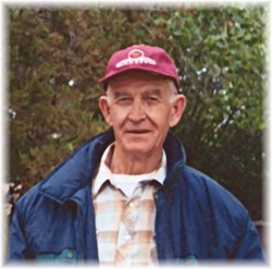
| Birth | : | 28 Aug 1925 Des Lacs, Ward County, North Dakota, USA |
| Death | : | 21 Apr 2017 Minot, Ward County, North Dakota, USA |
| Burial | : | Rolling Green Cemetery, Des Lacs, Ward County, USA |
| Coordinate | : | 48.1827000, -101.5657000 |
| Description | : | Clarence Cogdill of Burlington, died April 21, 2017. He was 91. Clarence was born August 28, 1925 in Des Lacs, ND to Delbert and Lois (Cowan) Cogdill. He was raised on the family farm and attended country schools in Des Lacs Township. As a young adult, he farmed in Rolling Green Township and was employed by Burlington Northern Railroad. He enlisted in the U.S. Navy on May 29, 1944 and was discharged on March 23, 1946. Clarence married Gwendolyn Sipes June 22, 1945 in Bloomington, Indiana. They made their home near Burlington and farmed small grains and... Read More |
frequently asked questions (FAQ):
-
Where is Clarence C. Cogdill's memorial?
Clarence C. Cogdill's memorial is located at: Rolling Green Cemetery, Des Lacs, Ward County, USA.
-
When did Clarence C. Cogdill death?
Clarence C. Cogdill death on 21 Apr 2017 in Minot, Ward County, North Dakota, USA
-
Where are the coordinates of the Clarence C. Cogdill's memorial?
Latitude: 48.1827000
Longitude: -101.5657000
Family Members:
Parent
Spouse
Siblings
Children
Flowers:
Nearby Cemetories:
1. Rolling Green Cemetery
Des Lacs, Ward County, USA
Coordinate: 48.1827000, -101.5657000
2. Township Cemetery
Ward County, USA
Coordinate: 48.1847000, -101.5472031
3. Burlington Township Cemetery
Des Lacs, Ward County, USA
Coordinate: 48.2452545, -101.5128174
4. Des Lacs Cemetery
Des Lacs, Ward County, USA
Coordinate: 48.2574997, -101.5749969
5. Larson Gravesite
Ward County, USA
Coordinate: 48.2700000, -101.5200000
6. Drady Cemetery
Minot, Ward County, USA
Coordinate: 48.1538048, -101.4261169
7. Hiland Cemetery
Ryder, Ward County, USA
Coordinate: 48.0729103, -101.6588669
8. Zion Lutheran Cemetery
South Prairie, Ward County, USA
Coordinate: 48.0524107, -101.5223840
9. Burlington Township Cemetery
Burlington, Ward County, USA
Coordinate: 48.2817421, -101.4292679
10. Fron Lutheran Cemetery
South Prairie, Ward County, USA
Coordinate: 48.0660638, -101.4143014
11. Early Settlers Cemetery
Ward County, USA
Coordinate: 48.0229301, -101.5136490
12. Anna Township Cemetery
Makoti, Ward County, USA
Coordinate: 48.0199410, -101.6152740
13. Hebrew Cemetery
Minot, Ward County, USA
Coordinate: 48.2467400, -101.3119500
14. Wild Rose Cemetery
Berthold, Ward County, USA
Coordinate: 48.3181000, -101.7461014
15. Zion Lutheran Cemetery (Defunct)
Minot, Ward County, USA
Coordinate: 48.2471500, -101.3111600
16. Saron Lutheran Cemetery
Ward County, USA
Coordinate: 48.0943985, -101.3181000
17. Witham Farm Cemetery
Freedom Township, Ward County, USA
Coordinate: 48.0525950, -101.3623800
18. Saint Marys Cemetery
Foxholm, Ward County, USA
Coordinate: 48.3717003, -101.5556030
19. Rosehill Memorial Park
Minot, Ward County, USA
Coordinate: 48.2238998, -101.2866974
20. First Lutheran Church Cemetery
Minot, Ward County, USA
Coordinate: 48.2470000, -101.2964000
21. Rose Valley Cemetery
South Prairie, Ward County, USA
Coordinate: 48.0527000, -101.3554993
22. Grueneberg Family Cemetery
Minot, Ward County, USA
Coordinate: 48.3268600, -101.3450600
23. Emmanuel Lutheran Cemetery
Ruthville, Ward County, USA
Coordinate: 48.3562851, -101.3823090
24. Sunset Memorial Gardens
Minot, Ward County, USA
Coordinate: 48.2997017, -101.2977982


