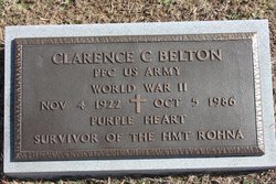
Clarence Conway Belton
| Birth | : | 4 Nov 1922 Surry County, North Carolina, USA |
| Death | : | 5 Oct 1986 Salisbury, Rowan County, North Carolina, USA |
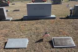
| Burial | : | Oakdale Cemetery, Mount Airy, Surry County, USA |
| Coordinate | : | 36.5177994, -80.6025009 |
| Plot | : | Section 18, Row P, Lot 18, Plot 1 |
| Description | : | HOUSE CONCURRENT RESOLUTION # 408 Passed the House of representatives October 10, 2000 Passed the U.S. Senate by Unanimous Consent October 27, 2000 Whereas on November 26, 1943, a German bomber off the coast of North Africa sunk the British transport HMT ROHNA with a radio controlled, rocket-boosted bomb; Whereas 1,015 United States service members and more than 100 British and Allied officers and crewmen perished as a result of the attack; Whereas hundreds died immediately when the bomb struck and hundreds more died when darkness and rough seas limited rescue efforts; Whereas many families still do not know the circumstances of the deaths of... Read More |
frequently asked questions (FAQ):
-
Where is Clarence Conway Belton's memorial?
Clarence Conway Belton's memorial is located at: Oakdale Cemetery, Mount Airy, Surry County, USA.
-
When did Clarence Conway Belton death?
Clarence Conway Belton death on 5 Oct 1986 in Salisbury, Rowan County, North Carolina, USA
-
Where are the coordinates of the Clarence Conway Belton's memorial?
Latitude: 36.5177994
Longitude: -80.6025009
Family Members:
Parent
Spouse
Siblings
Flowers:
Nearby Cemetories:
1. Oakdale Cemetery
Mount Airy, Surry County, USA
Coordinate: 36.5177994, -80.6025009
2. Grace Moravian God's Acre
Mount Airy, Surry County, USA
Coordinate: 36.5180016, -80.6042480
3. Campbell Cemetery
Mount Airy, Surry County, USA
Coordinate: 36.5135841, -80.6048172
4. First Baptist Church Columbarium
Mount Airy, Surry County, USA
Coordinate: 36.5071760, -80.6085860
5. Ararat Cemetery
Mount Airy, Surry County, USA
Coordinate: 36.5307999, -80.5922012
6. First Presbyterian Church Columbarium
Mount Airy, Surry County, USA
Coordinate: 36.4971990, -80.6057260
7. Catus Cemetery
Mount Airy, Surry County, USA
Coordinate: 36.5006111, -80.6212222
8. Old Methodist Cemetery
Mount Airy, Surry County, USA
Coordinate: 36.4948349, -80.6033630
9. Flat Rock Baptist Cemetery
Flat Rock, Surry County, USA
Coordinate: 36.5085983, -80.5749969
10. Salem United Methodist Church Cemetery
Salem, Surry County, USA
Coordinate: 36.5430565, -80.6026077
11. Mount Calvary Christian Methodist Episcopal Cemetery
Combstown, Surry County, USA
Coordinate: 36.5005470, -80.5794810
12. Mountain View Cemetery
Mount Airy, Surry County, USA
Coordinate: 36.5029660, -80.6304380
13. Sandy Level Cemetery
Toast, Surry County, USA
Coordinate: 36.5031013, -80.6307983
14. Creasy Family Cemetery
Mount Airy, Surry County, USA
Coordinate: 36.5131389, -80.6359722
15. Miracle Waters Worship Center Cemetery
Flat Rock, Surry County, USA
Coordinate: 36.5243250, -80.5691160
16. Old Hollow Primitive Baptist Church Cemetery
Toast, Surry County, USA
Coordinate: 36.4987221, -80.6281967
17. Critz Family Cemetery
Surry County, USA
Coordinate: 36.4960000, -80.6339170
18. Payne's Chapel Baptist Church Cemetery
Flat Rock, Surry County, USA
Coordinate: 36.5184200, -80.5609100
19. Norman Family Cemetery
Mount Airy, Surry County, USA
Coordinate: 36.4867516, -80.6183090
20. Midkiff Cemetery
Flat Rock, Surry County, USA
Coordinate: 36.5038986, -80.5642014
21. Oak Grove United Methodist Church Cemetery
Oak Grove (Mount Airy South), Surry County, USA
Coordinate: 36.4899770, -80.5757520
22. Midway Baptist Church Cemetery
Mount Airy, Surry County, USA
Coordinate: 36.5254170, -80.6467220
23. Forkner Cemetery
Mount Airy, Surry County, USA
Coordinate: 36.4978900, -80.5628510
24. Korner's Grove Primitive Baptist Church Cemetery
Flat Rock, Surry County, USA
Coordinate: 36.5359726, -80.5588913


