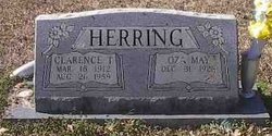
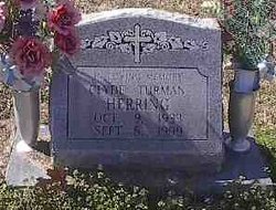
Clarence Turman Herring
| Birth | : | 18 Mar 1912 Oklahoma, USA |
| Death | : | 26 Aug 1989 |
| Burial | : | Pleasant Valley Cemetery, Dallison, Wood County, USA |
| Coordinate | : | 39.2477989, -81.3630981 |
| Description | : | Married Moyra Marie Webster 05 Apr 1933 in Polk, Arkansas, U.S.A.; marriage was performed by Rev. O.D. Bradshaw. Groom's residence: Wickes, Polk, Arkansas, U.S.A. Bride's residence: Wickes, Polk, Arkansas, U.S.A. License issued 04 Apr 1933, filed and recorded 11 Apr 1933, page 426, book Q, by M.M. Martin, Clerk, in Polk, Arkansas, U.S.A. Married Oza May Stewart 20 Jan 1951 in Sevier, Arkansas, U.S.A.; marriage was performed by King Ebbert Doss. Groom's residence: Wickes, Polk, Arkansas, U.S.A. Bride's residence: Wickes, Polk, Arkansas, U.S.A. License issued, filed and recorded 20 Jan 1951 by Minor Millwee, Clerk, in Sevier, Arkansas, U.S.A. |
frequently asked questions (FAQ):
-
Where is Clarence Turman Herring's memorial?
Clarence Turman Herring's memorial is located at: Pleasant Valley Cemetery, Dallison, Wood County, USA.
-
When did Clarence Turman Herring death?
Clarence Turman Herring death on 26 Aug 1989 in
-
Where are the coordinates of the Clarence Turman Herring's memorial?
Latitude: 39.2477989
Longitude: -81.3630981
Family Members:
Parent
Spouse
Siblings
Children
Nearby Cemetories:
1. Pleasant Hill Cemetery
Deerwalk, Wood County, USA
Coordinate: 39.2526207, -81.3277588
2. Herndon Chapel Cemetery
Parkersburg, Wood County, USA
Coordinate: 39.2756300, -81.3593100
3. Freshwater Cemetery
Ogden, Wood County, USA
Coordinate: 39.2711680, -81.3865000
4. Riser Cemetery
Deerwalk, Wood County, USA
Coordinate: 39.2187090, -81.3390880
5. Johnson Cemetery
Wood County, USA
Coordinate: 39.2050018, -81.3602982
6. German-Lutheran Cemetery
Parkersburg, Wood County, USA
Coordinate: 39.2488400, -81.3073100
7. Hendershot Cemetery
Tallyho, Wood County, USA
Coordinate: 39.2749990, -81.4098190
8. Grant Cemetery
Murphytown, Wood County, USA
Coordinate: 39.2230000, -81.4203000
9. Seaton Cemetery
Wood County, USA
Coordinate: 39.1959000, -81.3987400
10. Farson Cemetery
Murphytown, Wood County, USA
Coordinate: 39.2357400, -81.4375200
11. Greenhill Catholic Cemetery
Eaton, Wood County, USA
Coordinate: 39.1990400, -81.3200100
12. Farrow Cemetery
Murphytown, Wood County, USA
Coordinate: 39.2243000, -81.4347000
13. Snider Cemetery
Wood County, USA
Coordinate: 39.2010070, -81.4236500
14. Hubbs Cemetery
Saint Marys, Pleasants County, USA
Coordinate: 39.3050167, -81.3036833
15. Cross Family Cemetery
Red Hill, Wood County, USA
Coordinate: 39.2664900, -81.4566780
16. Mount Cemetery
Murphytown, Wood County, USA
Coordinate: 39.2167170, -81.4515120
17. Call-Riggleman Cemetery
Red Hill, Wood County, USA
Coordinate: 39.2755530, -81.4546670
18. Darling Cemetery
Wood County, USA
Coordinate: 39.3209390, -81.3942860
19. Beha Cemetery
Hanna, Wood County, USA
Coordinate: 39.1730200, -81.3914800
20. McMullen Cemetery
Wood County, USA
Coordinate: 39.2882530, -81.2751318
21. Johnson Cemetery
Pleasants County, USA
Coordinate: 39.3232994, -81.3277969
22. Deem Cemetery
Freeport, Wirt County, USA
Coordinate: 39.1822900, -81.2990300
23. Red Hill United Methodist Church Cemetery
Red Hill, Wood County, USA
Coordinate: 39.2476400, -81.4731100
24. Harness Cemetery
Pleasants County, USA
Coordinate: 39.3344002, -81.3591995

