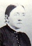
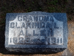
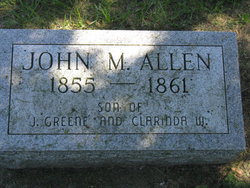
Clarinda L. Walker Wood Allen
| Birth | : | 6 Oct 1825 Casey County, Kentucky, USA |
| Death | : | 7 Dec 1911 Rhodes, Marshall County, Iowa, USA |
| Burial | : | Malbina General Cemetery, Malbina, Derwent Valley Council, Australia |
| Coordinate | : | -42.7866610, 147.1184830 |
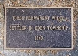
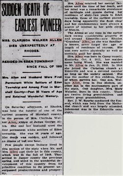
| Description | : | The second settlers and first permanent settlers in Eden Township were James Greene Allen and his wife Clarinda and six month old daughter, Mary Emily. They came by covered wagon from Casey County, Kentucky. They entered land at the land office in Iowa City and came to Jasper County in the spring of 1849. He received land as an assignee of John Whittle, a private in Captain Graves' Company, 16th Regiment of the United States Infantry. He obtained the E 1/2 of the SE 1/4 of Section 8 - 82 - 20 and the W 1/2 of the SW 1/4... Read More |
frequently asked questions (FAQ):
-
Where is Clarinda L. Walker Wood Allen's memorial?
Clarinda L. Walker Wood Allen's memorial is located at: Malbina General Cemetery, Malbina, Derwent Valley Council, Australia.
-
When did Clarinda L. Walker Wood Allen death?
Clarinda L. Walker Wood Allen death on 7 Dec 1911 in Rhodes, Marshall County, Iowa, USA
-
Where are the coordinates of the Clarinda L. Walker Wood Allen's memorial?
Latitude: -42.7866610
Longitude: 147.1184830
Family Members:
Children
Flowers:
Nearby Cemetories:
1. Malbina General Cemetery
Malbina, Derwent Valley Council, Australia
Coordinate: -42.7866610, 147.1184830
2. St. Matthew’s Anglican Columbarium Wall
New Norfolk, Derwent Valley Council, Australia
Coordinate: -42.7792220, 147.0673080
3. Saint Matthew's Anglican Cemetery
New Norfolk, Derwent Valley Council, Australia
Coordinate: -42.7806289, 147.0664250
4. New Norfolk Old Cemetery
New Norfolk, Derwent Valley Council, Australia
Coordinate: -42.7719330, 147.0579860
5. Jackman Graveyard
Collinsvale, Glenorchy City, Australia
Coordinate: -42.8406720, 147.1639470
6. Lawitta Church Cemetery
Magra, Derwent Valley Council, Australia
Coordinate: -42.7661690, 147.0331060
7. Collinsvale Uniting Church Cemetery
Collinsvale, Glenorchy City, Australia
Coordinate: -42.8410560, 147.1991720
8. Hestercombe Uniting Church Cemetery
Austins Ferry, Glenorchy City, Australia
Coordinate: -42.7695190, 147.2448030
9. St. Mary's Anglican Cemetery
Bridgewater, Brighton Council, Australia
Coordinate: -42.7374010, 147.2282310
10. St. Paul's Anglican Church Cemetery
Glenorchy, Glenorchy City, Australia
Coordinate: -42.8275410, 147.2665830
11. Glenorchy Chapel Burial Ground
Glenorchy, Glenorchy City, Australia
Coordinate: -42.8317820, 147.2704320
12. St Matthews Church Cemetery
Glenorchy, Glenorchy City, Australia
Coordinate: -42.8329730, 147.2743670
13. St George's Church of England Cemetery
Gagebrook, Brighton Council, Australia
Coordinate: -42.7499706, 147.2793948
14. Plenty Anglican Church Cemetery
Plenty, Derwent Valley Council, Australia
Coordinate: -42.7382900, 146.9605860
15. Pontville Saint Matthews Roman Catholic Cemetery
Brighton, Brighton Council, Australia
Coordinate: -42.6900390, 147.2629800
16. St John’s Anglican Church Cemetery
New Town, Hobart City, Australia
Coordinate: -42.8550230, 147.2969180
17. St. Augustine's Anglican Cemetery
Broadmarsh, Southern Midlands Council, Australia
Coordinate: -42.6380880, 147.1158740
18. East Risdon Cemetery
Risdon, Clarence City, Australia
Coordinate: -42.8211910, 147.3184970
19. New Town Congregational Cemetery
New Town, Hobart City, Australia
Coordinate: -42.8545680, 147.3026230
20. St. Mark's Anglican Cemetery
Pontville, Southern Midlands Council, Australia
Coordinate: -42.6807150, 147.2663860
21. Broadmarsh Congregational Cemetery
Broadmarsh, Southern Midlands Council, Australia
Coordinate: -42.6344620, 147.1129760
22. Hobart Garden of Remembrance
New Town, Hobart City, Australia
Coordinate: -42.8502900, 147.3167000
23. Hobart War Cemetery
Cornelian Bay, Hobart City, Australia
Coordinate: -42.8502900, 147.3167000
24. Cornelian Bay Cemetery And Crematorium
Hobart, Hobart City, Australia
Coordinate: -42.8513600, 147.3170400

