
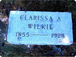
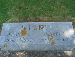
Clarissa Angelic “Clara” Hilts Wilkie
| Birth | : | 29 Jan 1855 Floyd County, Iowa, USA |
| Death | : | 23 Feb 1928 Rockford, Floyd County, Iowa, USA |
| Burial | : | Riverside Cemetery, Rockford, Floyd County, USA |
| Coordinate | : | 43.0578003, -92.9464035 |
| Plot | : | Section 2 |
| Description | : | Unknown paper, Undated Mrs. Clara A. Wilke In Kent County, Michigan, John and Mary Jane Hilts were living when on January 30, 1855, was born to them a baby girl to whom they gave the name Clarissa. The years came and went that brought her to the threshold of young womanhood. And on the first day of February, fifty-four years ago, she and William J. Wilkie took upon themselves the marriage vows at Shabbona, Illinois. About eight years later the family moved into Iowa, setting at Rockford, which has since been the family's place of... Read More |
frequently asked questions (FAQ):
-
Where is Clarissa Angelic “Clara” Hilts Wilkie's memorial?
Clarissa Angelic “Clara” Hilts Wilkie's memorial is located at: Riverside Cemetery, Rockford, Floyd County, USA.
-
When did Clarissa Angelic “Clara” Hilts Wilkie death?
Clarissa Angelic “Clara” Hilts Wilkie death on 23 Feb 1928 in Rockford, Floyd County, Iowa, USA
-
Where are the coordinates of the Clarissa Angelic “Clara” Hilts Wilkie's memorial?
Latitude: 43.0578003
Longitude: -92.9464035
Family Members:
Parent
Spouse
Siblings
Children
Flowers:


Nearby Cemetories:
1. Riverside Cemetery
Rockford, Floyd County, USA
Coordinate: 43.0578003, -92.9464035
2. Ulsterville Cemetery
Ulster Township, Floyd County, USA
Coordinate: 43.0936012, -92.8842010
3. Flood Creek Cemetery
Floyd County, USA
Coordinate: 43.0391998, -92.8538971
4. Rock Grove Township Cemetery
Nora Springs, Floyd County, USA
Coordinate: 43.1227989, -92.9880981
5. Rudd Evergreen Cemetery
Rudd, Floyd County, USA
Coordinate: 43.1417007, -92.9214020
6. Park Cemetery
Nora Springs, Floyd County, USA
Coordinate: 43.1444016, -92.9982986
7. Saint Marys Catholic Cemetery
Roseville, Floyd County, USA
Coordinate: 43.0090000, -92.8134000
8. West Saint Charles United Methodist Cemetery
Floyd County, USA
Coordinate: 43.0580597, -92.7897186
9. Westside Cemetery
Marble Rock, Floyd County, USA
Coordinate: 42.9556007, -92.8739014
10. Hillside Cemetery
Marble Rock, Floyd County, USA
Coordinate: 42.9583015, -92.8666992
11. Spring Grove Cemetery
Nora Springs, Floyd County, USA
Coordinate: 43.1631012, -93.0211029
12. Owens Grove Cemetery
Cerro Gordo County, USA
Coordinate: 43.0825005, -93.1144180
13. Saint Patricks Catholic Cemetery
Dougherty, Cerro Gordo County, USA
Coordinate: 42.9227791, -93.0294418
14. Eden Presbyterian Cemetery
Meroa, Mitchell County, USA
Coordinate: 43.2131004, -92.9103012
15. West End Cemetery
Meroa, Mitchell County, USA
Coordinate: 43.2216682, -92.9250031
16. Oakwood Cemetery
Floyd, Floyd County, USA
Coordinate: 43.1178017, -92.7307968
17. Dudley Cemetery
Dudley (historical), Mitchell County, USA
Coordinate: 43.2252998, -92.8743973
18. Rock Creek Cemetery
Meroa, Mitchell County, USA
Coordinate: 43.2352791, -92.9225006
19. Halls Grove Cemetery
Greene, Butler County, USA
Coordinate: 42.8840100, -92.8782300
20. Rock Falls Cemetery
Rock Falls, Cerro Gordo County, USA
Coordinate: 43.2122192, -93.0858307
21. Pleasant Grove Cemetery
Powersville, Floyd County, USA
Coordinate: 42.9441986, -92.7446976
22. Calvary Cemetery
Osage, Mitchell County, USA
Coordinate: 43.2238998, -92.8300018
23. Riverside Cemetery
Charles City, Floyd County, USA
Coordinate: 43.0766983, -92.6881027
24. West Fork Cemetery
Franklin County, USA
Coordinate: 42.8918991, -93.0836029