

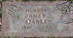
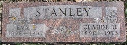
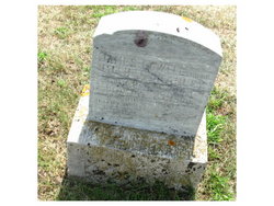
Claude Ulmont Stanley
| Birth | : | 10 Apr 1890 Sloan, Woodbury County, Iowa, USA |
| Death | : | 5 Aug 1973 Ponca, Dixon County, Nebraska, USA |
| Burial | : | Cogswell Cemetery, Williams County, USA |
| Coordinate | : | 41.6417007, -84.6025009 |
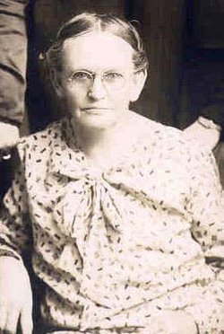
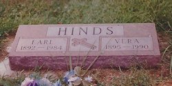
| Description | : | Sioux City Journal Mon 8-6-1973 pg 5 Claude U. Stanley, 83, 1027 La Plante Ave., died Sunday at the home of his sister, Mrs. (Vera) Earl Hinds, in Ponca, Neb., of an apparent heart attack. He had been under care of a physician for a heart condition. Mr. Stanley was born April 10, 1890, at Sloan. He moved to Dixon County with his parents as a boy. He farmed until retiring in 1960. He married Eva Phipps Dec. 24, 1914. She died in 1957. He married Mrs. Lennie Hay in 1958. He was a member of Riverside... Read More |
frequently asked questions (FAQ):
-
Where is Claude Ulmont Stanley's memorial?
Claude Ulmont Stanley's memorial is located at: Cogswell Cemetery, Williams County, USA.
-
When did Claude Ulmont Stanley death?
Claude Ulmont Stanley death on 5 Aug 1973 in Ponca, Dixon County, Nebraska, USA
-
Where are the coordinates of the Claude Ulmont Stanley's memorial?
Latitude: 41.6417007
Longitude: -84.6025009
Family Members:
Parent
Spouse
Siblings

Children

Flowers:


Nearby Cemetories:
1. Cogswell Cemetery
Williams County, USA
Coordinate: 41.6417007, -84.6025009
2. Floral Grove Cemetery
Pioneer, Williams County, USA
Coordinate: 41.6650009, -84.5460968
3. Heritage Cemetery
Ainger, Williams County, USA
Coordinate: 41.6211014, -84.6613998
4. Pease Cemetery
Pioneer, Williams County, USA
Coordinate: 41.6946983, -84.6014023
5. Riverside Cemetery
Montpelier, Williams County, USA
Coordinate: 41.5839005, -84.6177979
6. Lash Cemetery
Williams County, USA
Coordinate: 41.5868988, -84.5597000
7. Eagle Creek Cemetery
Williams County, USA
Coordinate: 41.6067900, -84.6744200
8. Louden Cemetery
Montpelier, Williams County, USA
Coordinate: 41.5758018, -84.6006012
9. Baker Cemetery
Amboy Township, Hillsdale County, USA
Coordinate: 41.7092018, -84.5969009
10. Gardner Cemetery
Williams County, USA
Coordinate: 41.6791992, -84.6785965
11. Bechtol Cemetery
Montpelier, Williams County, USA
Coordinate: 41.5714490, -84.6005000
12. Hagaman Cemetery
Amboy Township, Hillsdale County, USA
Coordinate: 41.7089005, -84.6339035
13. Osborne Cemetery
Adams Township, Hillsdale County, USA
Coordinate: 41.7086110, -84.6400000
14. West Jefferson Cemetery
West Jefferson, Williams County, USA
Coordinate: 41.5764008, -84.5563965
15. Bechtol Cemetery #2
Montpelier, Williams County, USA
Coordinate: 41.5782060, -84.5391850
16. Barrett Cemetery
Williams County, USA
Coordinate: 41.6293983, -84.4961014
17. Alfred Cemetery
Amboy Township, Hillsdale County, USA
Coordinate: 41.7220750, -84.5924630
18. Kunkle Cemetery
Kunkle, Williams County, USA
Coordinate: 41.6255989, -84.4950027
19. Robison Farm Cemetery
Camden, Hillsdale County, USA
Coordinate: 41.7081310, -84.6698610
20. East Amboy Cemetery
Amboy Township, Hillsdale County, USA
Coordinate: 41.7221985, -84.5721970
21. Mary Bechtol Gravesite
Montpelier, Williams County, USA
Coordinate: 41.5575900, -84.6034900
22. Bistline Cemetery
West Unity, Williams County, USA
Coordinate: 41.5995650, -84.4909490
23. Nettle Lake Cemetery
Nettle Lake, Williams County, USA
Coordinate: 41.6850014, -84.7136002
24. Cellars Cemetery
Austin, Hillsdale County, USA
Coordinate: 41.7312750, -84.6498940