


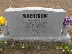
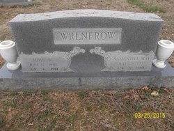
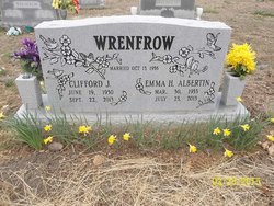
Clifford Joseph Wrenfrow
| Birth | : | 19 Jun 1930 Ravenden, Lawrence County, Arkansas, USA |
| Death | : | 22 Sep 2013 Thayer, Oregon County, Missouri, USA |
| Burial | : | Byrd Cemetery, Myrtle, Oregon County, USA |
| Coordinate | : | 36.5186005, -91.3143997 |
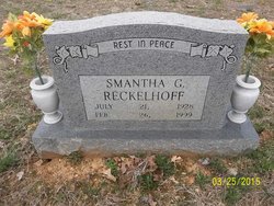
| Description | : | Clifford Wrenfrow was born the son of John Woodrow Wrenfrow and Samantha Mae (Garrison) Wrenfrow on June 19, 1930 in Ravenden, Arkansas, and departed this life September 22, 2013 in Thayer, Missouri, at the age of 83 years. He was united in marriage on October 13, 1956 in California, Missouri to Emma Albertin, who preceded him in death on July 23, 2013. He is survived by one son, Daniel Joseph Wrenfrow and wife, Terri of Thayer, Missouri; one daughter, Mary Colette Schlernitzauer and husband, Frank of Clarksville, Tennessee; four grandchildren, Danielle Daniels and husband, Shawn of Benton, Tennessee, Timothy Trey Wrenfrow and... Read More |
frequently asked questions (FAQ):
-
Where is Clifford Joseph Wrenfrow's memorial?
Clifford Joseph Wrenfrow's memorial is located at: Byrd Cemetery, Myrtle, Oregon County, USA.
-
When did Clifford Joseph Wrenfrow death?
Clifford Joseph Wrenfrow death on 22 Sep 2013 in Thayer, Oregon County, Missouri, USA
-
Where are the coordinates of the Clifford Joseph Wrenfrow's memorial?
Latitude: 36.5186005
Longitude: -91.3143997
Family Members:
Parent

Spouse
Siblings


Nearby Cemetories:
1. Crass Homestead
Myrtle, Oregon County, USA
Coordinate: 36.5359695, -91.3084671
2. Myrtle Cemetery
Myrtle, Oregon County, USA
Coordinate: 36.5133900, -91.2664300
3. Guiteau-Risner Cemetery
Guiteau, Oregon County, USA
Coordinate: 36.5588074, -91.3156128
4. Church of God Cemetery
Oregon County, USA
Coordinate: 36.5023500, -91.2580200
5. James Cemetery
Randolph County, USA
Coordinate: 36.4660988, -91.3435974
6. Arytown Cemetery
Arytown, Oregon County, USA
Coordinate: 36.5539513, -91.3795776
7. John Brown Cemetery
Jobe, Oregon County, USA
Coordinate: 36.5812111, -91.2953568
8. Garfield Cemetery
Garfield, Oregon County, USA
Coordinate: 36.5844400, -91.3253400
9. Davis Cemetery
Sharp County, USA
Coordinate: 36.4606018, -91.3574982
10. Taylor Cemetery
Ravenden Springs, Randolph County, USA
Coordinate: 36.4468994, -91.3293991
11. Russell Cemetery
Couch, Oregon County, USA
Coordinate: 36.5506477, -91.3991928
12. Cotton Creek Cemetery
Jobe, Oregon County, USA
Coordinate: 36.5844002, -91.2652969
13. O'Neal
Billmore, Oregon County, USA
Coordinate: 36.5712170, -91.2415410
14. Olon Tucker Farm Cemetery #2
Couch, Oregon County, USA
Coordinate: 36.5867000, -91.3705400
15. Wirth Cemetery
Wirth, Sharp County, USA
Coordinate: 36.4522018, -91.3806000
16. Old Jobe Cemetery
Jobe, Oregon County, USA
Coordinate: 36.5917015, -91.2517014
17. Rose Hill Cemetery
Thayer, Oregon County, USA
Coordinate: 36.5186386, -91.4263763
18. Pleasant Ridge Cemetery
Sharp County, USA
Coordinate: 36.4876710, -91.4221830
19. Spring Valley Cemetery
Billmore, Oregon County, USA
Coordinate: 36.5324670, -91.2003420
20. Old Elmore Thomas field
Billmore, Oregon County, USA
Coordinate: 36.5237770, -91.1980250
21. New Salem Cemetery
Couch, Oregon County, USA
Coordinate: 36.6042252, -91.3712463
22. Walnut Grove Cemetery
Elm Store, Randolph County, USA
Coordinate: 36.4914017, -91.1967010
23. Bellah Cemetery
Ravenden Springs, Randolph County, USA
Coordinate: 36.4207993, -91.2825012
24. Roberts Family Farm Cemetery
Couch, Oregon County, USA
Coordinate: 36.6165300, -91.2401700